Refine your search
Filtered by:
- Category
- List
- Grid
A subscription to the Price Guide is required to view results for auctions ten days or older. Click here for more information
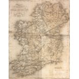

Lewis (S.) Atlas comprising the Counties of Ireland an a General Map of the Kingdom, lg. 4to L.
Lewis (S.) Atlas comprising the Counties of Ireland an a General Map of the Kingdom, lg. 4to L. 1837, lg. fold. map, & 29 engd. maps, cloth; [Curr...
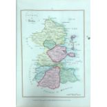
With Hand-Coloured MapsIrish Atlas: Scale (Bernard) An Hibernian Atlas; or General Description of the Kingdom of Ireland, 4to Lond. 1809. Improved...
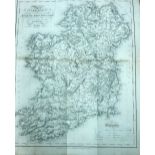
Lewis (Samuel) Atlas Comprising the Counties of Ireland and a General Map of the Kingdom, Folio L.
Lewis (Samuel) Atlas Comprising the Counties of Ireland and a General Map of the Kingdom, Folio L. 1837, First Edn., engd. title & contents, lg. f...
![With 77 Maps Hand-Coloured in Outline [Municipal Corporation Boundaries] Reports and Plans of the](https://portal-images.azureedge.net/auctions-2019/srfons10037/images/00b8113b-ee35-4e07-8870-aa5e00a8c02a.jpg?w=155&h=155)
With 77 Maps Hand-Coloured in Outline [Municipal Corporation Boundaries] Reports and Plans of the
With 77 Maps Hand-Coloured in Outline[Municipal Corporation Boundaries] Reports and Plans of the Municipal Corporation Boundaries given by His Exc...
Hardiman (James) The History of the Town and County of the Town of Galway, 4to D. (W. Fords & Son) 1820, First, fold. frontis & 10 maps & plts. (s...
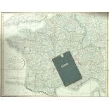
Map: Cary (John) Cary's New Map of France Divided into Departments as described by the National
Map: Cary (John) Cary's New Map of France Divided into Departments as described by the National Assembly January 1790, L. (J. Cary) Jan. 23rd 1814...
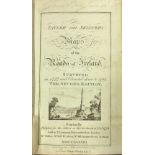
Taylor (George) & Skinner (Andrew) Maps of the Roads of Ireland Surveyed in 1777 and Corrected Down
Taylor (George) & Skinner (Andrew) Maps of the Roads of Ireland Surveyed in 1777 and Corrected Down to 1783, 8vo D. 1783 Second, fold. map frontis...
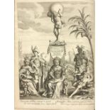
Cluverus (P.) Introduction in Universam Geographiam ... Ed. by J. Bunone. J.F. Hekelus & Joh.
Cluverus (P.) Introduction in Universam Geographiam ... Ed. by J. Bunone. J.F. Hekelus & Joh. Reiskius. 4to Lond. 1711. Engd. frontis & 60 engd. m...