Refine your search
Filtered by:
- Category
- List
- Grid
A subscription to the Price Guide is required to view results for auctions ten days or older. Click here for more information

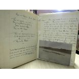
Praeger (R. Lloyd) Irish Topographical Botany, 8vo D. 1901 First Edn., fold. cold. map, v. good copy; The Way that I Went, An Irishman in Ireland....
Power (Rev. P.) The Placenames of Decies, 8vo L.1907. First Edn. map frontis., fold. maps, uncut, orig. quarter mor., gilt. Scarce. (1)
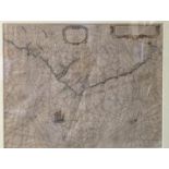
River Barrow DrainageCo. Carlow: Manning (Rob.) Report to the Commissioners of Public Works, Ireland, on the Drainage of the Lands along the River...
![Irish Language: [Commission na Gaeltachta] - Report & Maps, 1911 & 1925, 2 vols. D.](https://portal-images.azureedge.net/auctions-2017/srfons10026/images/00fac0c7-605d-4724-bdbd-fcbe6d68a946.jpg?w=155&h=155)
Irish Language: [Commission na Gaeltachta] - Report & Maps, 1911 & 1925, 2 vols. D. 1926, (pamphlets & fold. maps); together with Wagner (H.) Ling...
Nicholson (E.W. Byron) Keltic Researches, roy 8vo L. 1904, plts.; Ryan (Rev. J.) Irish Monasticism, D. 1931. First; Murphy (Rev. D.) Tiumphalie Ch...
![[Burckhardt (John Lewis)] Travels in Nubia, 4to, L. (J. Murray) 1822, Second Edn., engd. port.](https://portal-images.azureedge.net/auctions-2017/srfons10026/images/0582d61f-318a-4dab-c5ef-d10128decf7c.jpg?w=155&h=155)
[Burckhardt (John Lewis)] Travels in Nubia, 4to, L. (J. Murray) 1822, Second Edn., engd. port.
[Burckhardt (John Lewis)] Travels in Nubia, 4to, L. (J. Murray) 1822, Second Edn., engd. port. frontis, 3 maps (2 fold) contemp. hf. calf, marble ...
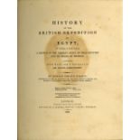
Wilson (Robert Thomas) History of the British Expedition to Egypt..., lg. 4to, L. 1803, Second Edn.
Wilson (Robert Thomas) History of the British Expedition to Egypt..., lg. 4to, L. 1803, Second Edn., hf. title, 2 fold. tables, 3 lg. fold maps at...
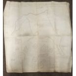
Co. Meath: Map: A Map of the Commons of Wilkinstown in the Co. of Meath also Part of Sir Qual Sommervils Estate intermix in the lands of Wilkinsto...
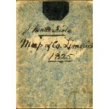
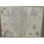
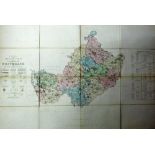
Limerick Grand Jury Map: Coffey (James) Map of the County of Limerick from the Latest Surveys, engd.
Limerick Grand Jury Map: Coffey (James) Map of the County of Limerick from the Latest Surveys, engd. by Sid Hall Lond. 1825, & Published & sold by...
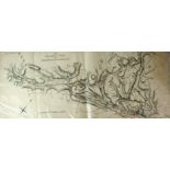
Irish Railway Commission Report: Two v. large hand coloured engraved Maps, Cahir to Clonmel and Waterford, and Mallow to Cork, and Blarney to Inch...
Irish Map / Chart: Anthoinie (Theunis) Jacobsz / Caspar Lootsman, De Zuyd oost Zyde Van yerlandt Van Dubling tot aen't Eylandt Corckbg 't Amsterda...
A 17th Century engraved Map of "The Countie of Leinster with the Citie of Dublin Described, by John Speed, approx. 37cms x 49cms (14 1/2" x 19 1/2...
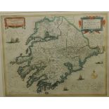
Fine Hand-Coloured Irish Maps, c. 1700Janson (Johannes) Provincia Mononiae - The Province of Mounster; and Comitatus Legeniae - The Countie of Lei...
Atlas - Blackie (W.G.) The Comprehensive Atlas and Geography of the World, folio L. 1886. cold.
Atlas - Blackie (W.G.) The Comprehensive Atlas and Geography of the World, folio L. 1886. cold. plts. text illus., & 67 mostly dbl. page cold. map...
Greene (Graham) Stamboul Train, 8vo L. (W. Heineman) 1932, First UK Edn., cloth; Journey without Maps, 8vo L. (W. Heineman) 1936, First UK Edn., I...
Maps: Diez (F.M.) Deutschland, Konigr. der Viederland, Komgr. Belgien und di Schweiz, Adolf Stieler's Gotha (Justus Perthes) 1851; Frey (Pl.) & co...
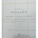
Map: Railway Commissioners: A General Map of Ireland to Accompany the Report of the Railway Commissioners, showing the Principal Physical Features...
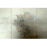
Ordnance Survey of Ireland: Province of Leinster, with Index Maps to the townland surveys of County Westmeath, Meath, Longford and Louth, together...
Ordnance Survey of Ireland: Province of Connaught with Index Maps to the Townland Surveys of County
Ordnance Survey of Ireland: Province of Connaught with Index Maps to the Townland Surveys of County Leitrim & Sligo, and also Index Map to Londond...
Ordnance Survey: County of Meath - Index Map to the Townland Survey, together with Sheets No's 14,
Ordnance Survey: County of Meath - Index Map to the Townland Survey, together with Sheets No's 14, 16, 22 & 23, together 5 lg. fold. linen backed ...
Box: Irish Topographical interest - West of Ireland, Clare, Limerick, Sligo, etc., also Offaly, Longford, Roscommon, Breifne, Midlands, Laois, Lou...