Filtered by:
- Category
- List
- Grid
A subscription to the Price Guide is required to view results for auctions ten days or older. Click here for more information

Four Large Maps of the Moon,
Four Large Maps of the Moon, Lunar Designations and Positions University of Arizona, c.1962, orthographic projection in four quadrants, quadrants...
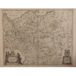
A 17th Century Map of Lithuania, Latvia, Poland, Prussia, Belarus, Ukraine and Russia, published c. 1662, Willem Janszoon Blaeu (1570–1630), cart...
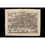
A 16th Century Map / Panorama of Vilnius, Lithuania, Published c. 1599, Braun & Hogenberg, map title ‘VILNA LITVANIAE’, Latin text to verso, uncol...
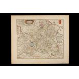
Two Early Maps of Poland,
Two Early Maps of Poland, Printed in Cologne, c.1592, detailed map of Southern Poland and the from the Weysel River in the north to the Carpathian...
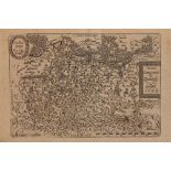
A 17th Century Map of Poland, Including Coats of Arms, Cherubs and cartouches published c.1680, J. Janssonius – Moses Pitt, cartouche reads ‘Novi...
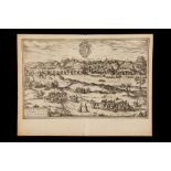
A 17th Century Bird’s-eye View of Grodno in Lithuania, A 17th Century Bird’s-eye View of Grodno in Lithuania, Georg Braun and c.1617, Frans Hogenb...
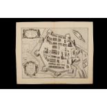
A 17th Century Map of Zamosc in Poland, C.1618, titled ‘Zamoscium. Nova Poloniae civitas, à magnifico eius regni Cancellaro à fundamentis exstruct...
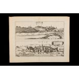
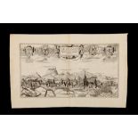
A 17th Century Bird’s-eye view of Sandomierz & Biecz, Poland, c.1617, Georg Braun and Frans Hogenberg, with bird’s-eye view of Sendomiria at top,...
A 17th Century Bird’s-eye View of Lviv in Ukraine, c.1617, Georg Braun and Frans Hogenberg, cartouche in the centre reads ‘Leopolis Russiae Austra...
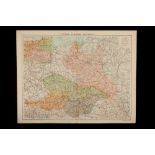
A Collection of Mainly 19th Century Maps of Central Europe & Poland, Various maps including some part maps x7 ...[more]
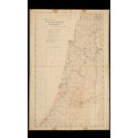
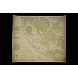
A Rare & Unusual Military Map of Palestine, dated 1942, title reads 'NOT TO BE PUBLISHED, Palestine North Sheet', map bordering Lebanon, Syria and...