
Filtered by:
- Category
- List
- Grid
A subscription to the Price Guide is required to view results for auctions ten days or older. Click here for more information

Morden (Robert), The New Description and State of England Containing the Maps of the Counties of
Morden (Robert), The New Description and State of England Containing the Maps of the Counties of England and Wales, 2nd edn, no frontis, pp 97-112...
Antoninus (Augustus), Antonini Iter Britanniarum Commentariis Illustratum Thomae Gale, fldg map, 2
Antoninus (Augustus), Antonini Iter Britanniarum Commentariis Illustratum Thomae Gale, fldg map, 2 plts, text illus, re-backed, cf gt, 4to, 1709.
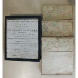
A New and Accurate Description of the Present Great Roads and the Principal Cross Roads of England
A New and Accurate Description of the Present Great Roads and the Principal Cross Roads of England and Wales, Commencing at London...... fldg engr...
Paterson (Daniel), A New and Accurate Description of all the Direct and Principal Cross Roads in
Paterson (Daniel), A New and Accurate Description of all the Direct and Principal Cross Roads in Great Britain, fldg engr map, 12mo, 1772.
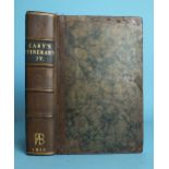
Cary (John), Cary's New Itinerary: or An Accurate Delineation of the Great Roads.... England and
Cary (John), Cary's New Itinerary: or An Accurate Delineation of the Great Roads.... England and Wales, 5 fldg engr maps, re-backed, hf cf gt, ori...
Cary (G & J), maps of Devon and Cornwall from The New Map of England, sheets 1-3, 8-10, 16 & 17, now
Cary (G & J), maps of Devon and Cornwall from The New Map of England, sheets 1-3, 8-10, 16 & 17, now rebound together with Explanation Sheet, all ...
Chauchard (Capt Jean Baptiste Hippolyte) A General Map of the Empire of Germany, Holland, the
Chauchard (Capt Jean Baptiste Hippolyte) A General Map of the Empire of Germany, Holland, the Netherlands, Switzerland, The Grisons, Italy, Sicily...
Five late-18th/early-19th century road maps of England and Wales: Bowle's Road Director 1803; Cary's
Five late-18th/early-19th century road maps of England and Wales: Bowle's Road Director 1803; Cary's Pocket Companion 1791; W Fadon to accompany P...
Devon, Ordnance Survey, The Second Part of the General Survey of England and Wales Containing the
Devon, Ordnance Survey, The Second Part of the General Survey of England and Wales Containing the Whole of Devon and a Portion of the Adjoining Co...
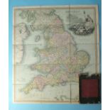
Cary (John), Cary's New Map of England and Wales with Part of Scotland on which are carefully laid
Cary (John), Cary's New Map of England and Wales with Part of Scotland on which are carefully laid down all the Direct and Principal Cross Roads, ...
Greenwood (C & J), Map of the County of Devon From an Actual Survey Made in the Years 1825 & 1826,
Greenwood (C & J), Map of the County of Devon From an Actual Survey Made in the Years 1825 & 1826, large-scale map in three sections, each section...
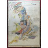
Walker (J & C), A Geological Map of England, Wales and Part of Scotland Showing also the Inland
Walker (J & C), A Geological Map of England, Wales and Part of Scotland Showing also the Inland Navigation with the Rail Roads and Principle Roads...
Mudge (Lt Col. William), Ordnance Survey Map Sheet XXVIII, Island of Lundy, sectionalised and laid
Mudge (Lt Col. William), Ordnance Survey Map Sheet XXVIII, Island of Lundy, sectionalised and laid on linen, 65 x 94cm, The Tower, 1820, bearing G...
Brookes' Travelling Companion through England and Wales, pub: William Darton, 2nd edn, sectionalised
Brookes' Travelling Companion through England and Wales, pub: William Darton, 2nd edn, sectionalised and laid on linen, 59.5 x 52.5cm, with slip c...
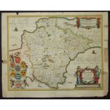
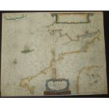
Jansson, Joannes, The Description of Devon-Shire, Amsterdam, no date, early colour in outline and
Jansson, Joannes, The Description of Devon-Shire, Amsterdam, no date, early colour in outline and wash, coloured title cartouche at lower right, h...
Waghenaer, Lucas Jansz, Zee Caerte van Engelants Eijndt, Alsoe hem tselfde Landt verthoont beginnede
Waghenaer, Lucas Jansz, Zee Caerte van Engelants Eijndt, Alsoe hem tselfde Landt verthoont beginnede van Sorlinges tot Pleijmondt, c1585, early co...
John Thomas & William Denys, A New Chart of Mounts Bay in Cornwall, with the Adjacent Coast, from
John Thomas & William Denys, A New Chart of Mounts Bay in Cornwall, with the Adjacent Coast, from Cape Lizard to Cape Cornwall, printed for Robt S...
Aurigarius, Lucas and Dotecum, Ioannes, Canalis Celebris vel Navigationis a Bristovio (Bristol
Aurigarius, Lucas and Dotecum, Ioannes, Canalis Celebris vel Navigationis a Bristovio (Bristol Channel & Welsh Coast), no date, uncoloured chart, ...
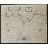
Seller, John, A Chart of the Channell of Bristoll, from Silly to St Davids Head, in Wales, Newly
Seller, John, A Chart of the Channell of Bristoll, from Silly to St Davids Head, in Wales, Newly corrected and published, Sold at his Shop, at the...
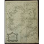
Seale, RW, A Correct Chart of St George's Channel and the Irish Sea, Including all the coast of
Seale, RW, A Correct Chart of St George's Channel and the Irish Sea, Including all the coast of Ireland, (For Rapin's History, 1745), uncoloured, ...
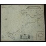
Seale, RW, A Correct Chart of the English Channel From the No. Foreland to the Lands End, (For
Seale, RW, A Correct Chart of the English Channel From the No. Foreland to the Lands End, (For Rapin's History, 1745), coloured outlines, four vig...
Van Keulen, GH, Nieuwe Paskaert Vande Verkeerde Canael Of De Kust Van Engelant, (Bristol Channel &
Van Keulen, GH, Nieuwe Paskaert Vande Verkeerde Canael Of De Kust Van Engelant, (Bristol Channel & South Coast of Wales), Amsterdam 1681, early ou...
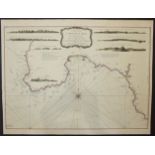
Van Keulen, GH, A New Gradually Encreasing Compass Map of a Part of the Sea Coasts of England, in
Van Keulen, GH, A New Gradually Encreasing Compass Map of a Part of the Sea Coasts of England, in which is contained the Coasts of Devonshire exte...
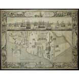
Milton, Thomas, A Geometrical plan and West Elevation of His Majesty's Dockyard near Plymouth,
Milton, Thomas, A Geometrical plan and West Elevation of His Majesty's Dockyard near Plymouth, with the Ordnance Wharf, etc, Feb. 2nd 1756, elabor...
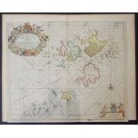
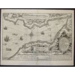
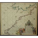
Collins, Grenville, The Islands of Scilly, From: Great Britain's Coasting Pilot, London 1693,
Collins, Grenville, The Islands of Scilly, From: Great Britain's Coasting Pilot, London 1693, early colouring, elaborate title cartouche with sea-...
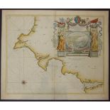
Collins, Grenville, Untitled, coast from Exmouth to Newton Ferry, from Collins' Coasting Pilot,
Collins, Grenville, Untitled, coast from Exmouth to Newton Ferry, from Collins' Coasting Pilot, London, 1693, engraved by I Harris, numbered '2', ...
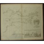
Collins, Grenville, The Severn or Channell of Bristol, Dedicated to Sir Robt Southwell who accompanied King William III on his Irish Expedition, w...
Laurie & Whittle, A Chart of The Isle, Roads and Race of Portland, with the Shambles, 53 Fleet
Laurie & Whittle, A Chart of The Isle, Roads and Race of Portland, with the Shambles, 53 Fleet Street, London, 1794, uncoloured, text in lower rig...
Van Keulen, Joannes, Pas-Kaert van de Canael, tusschen Engelandt en Vrancryck, Amsterdam, 1680,
Van Keulen, Joannes, Pas-Kaert van de Canael, tusschen Engelandt en Vrancryck, Amsterdam, 1680, the French coast is at the to, the English coast s...
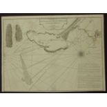
Lootsman, Jacob and Theunis, Jacobsz, De Custen van Engelant Tusschen de twee pointen van Poortland en Lezard, 1644, showing the Lizard, Torbay an...
Doncker, Hendrick, Cust van Engelandt, van Lezard tot Engelandt eynde, Amsterdam, no date, uncoloured, showing southern tip of Ireland, South Wale...
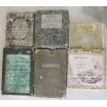
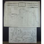
![Knapton, [A Draught of English Harbours], 1728, untitled, six small charts on one sheet, as follows:](https://portal-images.azureedge.net/auctions-2017/sreld10089/images/db6d64e5-2989-463e-d8ea-b9f9506800bc.jpg?w=155&h=155)
Knapton, [A Draught of English Harbours], 1728, untitled, six small charts on one sheet, as follows:
Knapton, [A Draught of English Harbours], 1728, untitled, six small charts on one sheet, as follows: Thames from Shooberry ness to London, Isle of...
Theunisz, Jacob, Cust van Engelant van Lezard tot Engelands cynd.........., Amsterdam, 1664, Plate
Theunisz, Jacob, Cust van Engelant van Lezard tot Engelands cynd.........., Amsterdam, 1664, Plate W13, coloured boundaries, showing Bristol Chann...
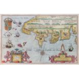
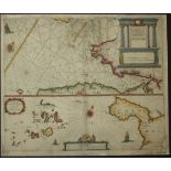
Speed, John & Norden, John, Cornwall, .......solde in Popes-Heade Alley against ye exchange by
Speed, John & Norden, John, Cornwall, .......solde in Popes-Heade Alley against ye exchange by John Sudbury and G Humble, early colouring, English...
Sayer, R, A chart of the Chops of the Channel to the South of Scilly Islands; containing The West
Sayer, R, A chart of the Chops of the Channel to the South of Scilly Islands; containing The West Coast of Cornwall & Scilly Islands, Revised by M...
Sandercock, Robert, Altarnun Cornwall, 1847, Map of Part of the Manor of Penpont and Treglasta, with
Sandercock, Robert, Altarnun Cornwall, 1847, Map of Part of the Manor of Penpont and Treglasta, with Parish of Altarnun, Davidstow and St Clether,...
A hand-drawn map of Devonshire divided into Hundreds, William Salter 1850 and other Devon and
A hand-drawn map of Devonshire divided into Hundreds, William Salter 1850 and other Devon and Plymouth-related maps and 18th century coastal chart...
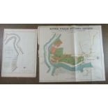
A Sketch of the Entrance to the Yealme River, Pub. Laurie & Whittle 1795, 55 x 39cm, a coloured plan
A Sketch of the Entrance to the Yealme River, Pub. Laurie & Whittle 1795, 55 x 39cm, a coloured plan for the River Yealm Building Estate, July 30t...
William Kipp, a 17th century map of Cornwall, hand-coloured, 31 x 40cm and other coloured and
William Kipp, a 17th century map of Cornwall, hand-coloured, 31 x 40cm and other coloured and uncoloured maps and charts.
Degaulle Ballanger Sculpt. 1810, Nouvelle Carte Réduite De La Manche De Bretagne (En Trois Feuilles), 97 x 66cm and other Ministre De La Marine co...
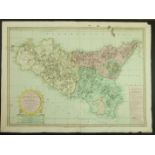
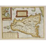
P Duval, La Sicile avec les aucigus noms de presque toutes ses places, Rivierts, Chasteaux, etc,
P Duval, La Sicile avec les aucigus noms de presque toutes ses places, Rivierts, Chasteaux, etc, Paris 1676, coloured boundaries, centre fold crea...
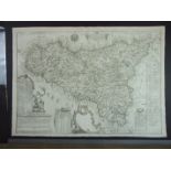
Mylne, Robert, after C Ventimiglio and Aedone, The Island & Kingdom of Sicily........ from the Map
Mylne, Robert, after C Ventimiglio and Aedone, The Island & Kingdom of Sicily........ from the Map of the Baron De Schmettau, Laurie & Whittle, Lo...
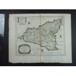
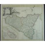
Ventimiglio, Carlo, Sicilia, 1786, uncoloured, centre fold, top and side margins strengthened, image
Ventimiglio, Carlo, Sicilia, 1786, uncoloured, centre fold, top and side margins strengthened, image 70.2 x 48.7cm, large title cartouche.
Homann, Regui & Insulae Siciliae Tabula Geographica, 1747, early colour, centre fold, small tear
Homann, Regui & Insulae Siciliae Tabula Geographica, 1747, early colour, centre fold, small tear in lower margin without loss, good margins, image...
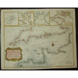
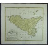
Senex, John, A Map of the Island & Kingdom of Sicily from the Latest Observations, London, 1721,
Senex, John, A Map of the Island & Kingdom of Sicily from the Latest Observations, London, 1721, coloured border and boundaries, centre fold, figu...
Ortelius, Abraham, Sicilae Veteris Typus, 1696, early colour, centre fold, inset map of Syracuse
Ortelius, Abraham, Sicilae Veteris Typus, 1696, early colour, centre fold, inset map of Syracuse in top left corner, text box in lower left corner...
Hole, W, Untitled, Sicily with inset boxes for Syracuse and Carthage, 1628, uncoloured, centre fold,
Hole, W, Untitled, Sicily with inset boxes for Syracuse and Carthage, 1628, uncoloured, centre fold, a couple of small faint spots at the top, nar...
Munster, Sebastian, Cosmographia Universalis, c1555, Folio 285, Sicilie, early colour, German text
Munster, Sebastian, Cosmographia Universalis, c1555, Folio 285, Sicilie, early colour, German text verso, grubby margins, Folio 378, Der Inseln un...
Brion, Deux Siciles avec les Metropoles Ecclesiastiques, Paris 1790, From Geographie Moderne,
Brion, Deux Siciles avec les Metropoles Ecclesiastiques, Paris 1790, From Geographie Moderne, Historique et Politique, coloured boundaries, text i...
A facsimile map by M Moleiro, "Mapa Portulano La Carta de Colon", another double-sided map "Atlas
A facsimile map by M Moleiro, "Mapa Portulano La Carta de Colon", another double-sided map "Atlas Miller", contained in triangular shape cases and...
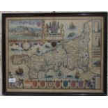
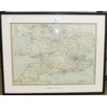
Blaeu, a 16th/17th century map, "Devonia Vulgo, Devonshire", framed.
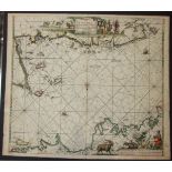
Romana De Hooghe, a large copper-engraved hand-coloured map, "The English Riviera" Carte Maritime
Romana De Hooghe, a large copper-engraved hand-coloured map, "The English Riviera" Carte Maritime D'Angleterre, hand-coloured and framed.
Waghenaer, Lucas Jaszoon, "A Description of the Sea Coast of England between Plymouth and Portland",
Waghenaer, Lucas Jaszoon, "A Description of the Sea Coast of England between Plymouth and Portland", a hand-coloured map.
A 'Great Western Railway Plymouth Great Western Docks' map printed on linen, 40 x 40.5cm, a Railway System 1902 map for Midland, Southern England ...
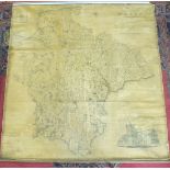
A C&J Greenwood map of The County of Devon, From an Original Survey......... publ.1827, with
A C&J Greenwood map of The County of Devon, From an Original Survey......... publ.1827, with engraving of Exeter Cathedral and map of Lundy inset,...