Filtered by:
- Category
- List
- Grid
A subscription to the Price Guide is required to view results for auctions ten days or older. Click here for more information
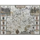

John Speed (British 1552-1629): 'Surrey Described and Divided into Hundreds', engraved map with hand-colouring and gilding, with inset views of Ri...
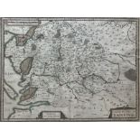
Jodocus Hondius (Dutch/Flemish 1594-1629) & Hendrik Hondius (Dutch/Flemish 1597-1651): Carte du Pais
Jodocus Hondius (Dutch/Flemish 1594-1629) & Hendrik Hondius (Dutch/Flemish 1597-1651): Carte du Pais de Xaintonge (Western France), engraved map w...
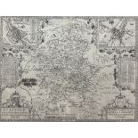
After John Speed (British 1552-1629): 'Stafford Countie and Towne with the ancient Citie Litchfield
After John Speed (British 1552-1629): 'Stafford Countie and Towne with the ancient Citie Litchfield described', engraved 18th century map 39cm x 5...
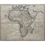
Thomas Bowen (British ?-1790): 'A New and Accurate Map of Africa Drawn from the best Authorities'
Thomas Bowen (British ?-1790): 'A New and Accurate Map of Africa Drawn from the best Authorities', engraved map with hand colouring pub.1777, 34cm...
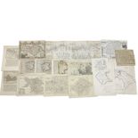
Emanuel Bowen (British 1694-1767): 'A Survey of the River Dunn... Hull to Doncaster to Sheffield by
Emanuel Bowen (British 1694-1767): 'A Survey of the River Dunn... Hull to Doncaster to Sheffield by Will Palmer', engraved map pub. 1722; Thomas M...