Filtered by:
- Category
- List
- Grid
A subscription to the Price Guide is required to view results for auctions ten days or older. Click here for more information

Heylyn (Peter). Cosmography, in Four Books. Containing the Chorography and History of the Whole World, and all the Principal Kingdoms, Provinces, ...
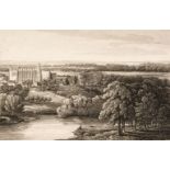
Bailey (George). Six Etchings of Ye Antient Commandery by George Bailey (of Derby), Worcester, Littlebury & Company, The Worcester Press, At Ye An...
![Lewis (Samuel). [A Topographical Dictionary of England ..., Atlas volume only, 1831]](https://portal-images.azureedge.net/auctions-2020/srdom10158/images/6c321ed9-c7ed-4ad8-a4c0-ac6001173049.jpg?w=155&h=155)
[Lewis (Samuel). A Topographical Dictionary of England ..., Atlas volume only, London: S.Lewis and Co., 1831], title deficient, folding engraved m...

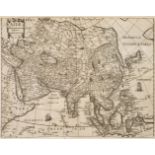
Arrowsmith (Aaron). Memoir relative to the Construction of the Map of Scotland published by Aaron Arrowsmith in the Year 1807, 1st edition, London...
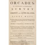
Mackenzie (Murdoch). Orcades: or, a Geographic and Hydrographic Survey of the Orkney and Lewis Islands, in Eight Maps ... The third edition, with ...
Thomson (John). The Atlas of Scotland, 1st edition, Edinburgh: for John Thomson & Co., 1832, pp. [4] viii 18, engraved 'Index Map' hand-coloured i...
Austen & Co. (publishers). A Safety Guide for those contemplating a trip on the Sea of Matrimony, Chicago, 1906, a used postcard (with a 1908 post...
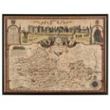
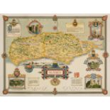
* Berkshire. Speed (John), Barkshire Described, 1st edition, John Sudbury & George Humble, [1611], hand coloured engraved map with a panorama of W...
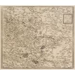
Blaeu (Johannes). Staffordiensis comitatus vulgo Stafford Shire, Amsterdam, circa 1650, engraved map with contemporary outline colouring, large de...
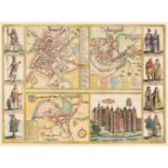
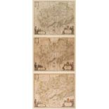
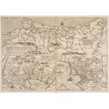
Braun (Georg & Hogenberg Franz). Yorke, Shrowesbury, Lancaster & Richmont, circa 1617, four hand-coloured engraved plans on one sheet (as publishe...
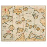
Bruce (John). A Map of Matrimony, circa 1840, engraved map with contemporary hand colouring, printed on a card with blind-stamped embossed foliate...
Cardiganshire. Speed (John), Cardigan Shyre described with the due forme of the Shire-town as it was surveyed by J. S. Anno 1610, John Sudbury and...
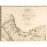
Cheshire. Greenwood (C.), Map of the County Palatine of Chester from an actual survey made in the year 1819, Wm. Fowler Wakefield & C. Greenwood, ...
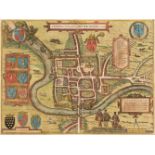
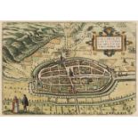
Chester. Braun (Georg & Hogenberg Franz), Cestria (vulgo) Chester Angliae Civitas, Cologne, 1581, engraved city plan with contemporary hand colour...
Clegg (Ernest). Three pictorial English county maps, Sussex, Kent & The West Riding of Yorkshire, John Waddington, Leeds, 1945 - 46, three colour ...
Czechoslovakia. Braun (Georg & Hogenberg Franz). Znaymum vulgo Znaym, Moraviae Civitas Primaria, Amsterdam [1617 - 1657], hand coloured city plan ...
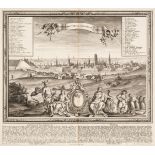
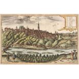
Danzig/Gdansk. Werner (Friedrich Bernhard & Scheffler Thomas), Dantiscum vel Gedanum Dantzig, Martin Engelbrecht, Augsburg, 1734, uncoloured prosp...
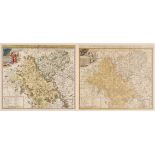
Derbyshire. (Greenwood (C. & J.), Map of the County of Derby, from an actual survey made in the years 1824 & 1825..., Greenwood, Pringle & Co., 18...
* Devon. Blaeu (Johannes), Devonia vulgo Devon-shire, Amsterdam, circa 1645, engraved map with contemporary outline colouring, decorative cartouch...
* Devon. Speed (John), Devonshire with Excester described and the Armes of such Nobles as have borne the titles of them, John Sudbury & George Hum...
* Dorset. Speed (John), Dorsetshyre with the Shyre Towne Dorchester described, as also the Armes of such noble families as have bene honored with ...
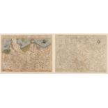
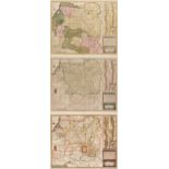
Durham, Cumberland & Westmorland. A collection of 30 maps, 17th - 19th century, engraved maps, including examples by Morden (large and small forma...
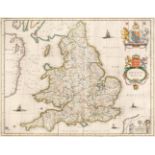
England & Wales. Blaeu (J.), Anglia Regnum, circa 1650, engraved map with contemporary outline colouring, some creasing and strengthening to verso...
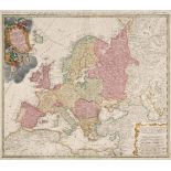
Europe. Homann (Johann Baptist heirs of), Europa Secundum Legitimas Projectionis Stereographicae Regulas..., 1743, engraved map with contemporary ...
Europe. Mansfeld (J. E.), Post Charte der Kaiserl. Konigl. Erblanden..., George Metzburg, Vienna, 1782, a large engraved map with contemporary out...
Folding maps. A mixed collection of fourteen maps, mostly 19th century, including Lewis (Samuel). A Map of England & Wales Divided into Counties, ...
France. A collection of 22 maps of France, 16th - 18th century, engraved regional maps, country maps and town plans, with examples by Faden, Munst...
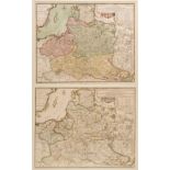
Germany. A collection of thirteen maps, 16th - 18th century, engraved maps of the country and regions, including examples by Ortelius, Gastaldi, L...
Germany. Braun (Georg & Hogenberg Franz), Calcaria Ducatus Clivensis Multis Dotibus Nobile Opp: circa 1618, coloured engraved plan of Kalkar near ...
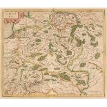
* Germany/Saxony. De Jode (Cornelis), Saxonum Regionis Quatenus eius Gentis Imperium Nomenque Antwerp, 1593, engraved map with contemporary hand c...
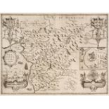
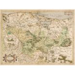
* Gloucestershire. Saxton (C. & Hole G.), Glocestriae comitatus olim sedes Dobunorum, [1637], hand-coloured engraved map, large strapwork cartouch...
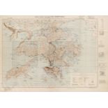
Hong Kong. Hong Kong and the New Territories, 3rd edition (with grid correction), War office publication, 1946, Reprinted from HIND 1015, Mar. 194...
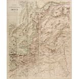
India. Stanford's Sketch map of the North-Western Frontier of India, Edward Stanford, 1897, colour lithographic map, sectionalised and laid on lin...
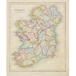
Ireland. A collection of thirty maps, mostly 19th century, engraved maps, many with contemporary outline colouring, with examples by Johnston, Wel...
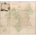
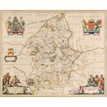
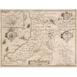
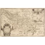
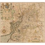
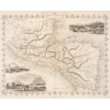
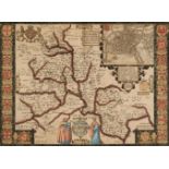
Leicestershire. Prior (John), To the Right Honourable Francis Earl of Huntingdon, Baron Hastings, Hungerford, Newmark, Peverel, Botreaux, Molins, ...
* Lithuania. Mercator (Gerard), Lithuania, circa 1619, engraved map with contemporary outline colouring, some overall toning, slight text show thr...
* Lithuania. Jansson (Jan), Magni Ducatus Lithuaniae Caeterarump Regionum illi Adjacentium exacta descrip..., circa 1680, hand-coloured engraved m...
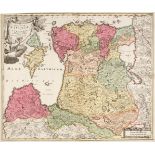
Livonia. Homann (Johannes Baptist), Ducatuum Livoniae et Curlandiae cum vicinis Insulis Nova Exhibitio Geographica, Amsterdam, circa 1720, engrave...
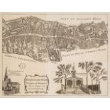
London Ward Plans. A collection of nine ward plans, published in 'The London Magazine', circa 1770, uncoloured engraved ward plans, old folds, eac...
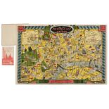
London. Geographia Ltd (publisher). The New Pictorial Map of London, circa 1935, folding chromolithographic pictorial and allegorical map of Londo...
Maps. A mixed collection of approx. 250 British & Foreign maps, mostly 19th century, engraved and lithographic foreign and British county and regi...
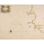
Maps. Collins (Capt. Greenville), Milford Haven and the Islands adjacent..., circa 1700, hand-coloured engraved chart, decorative cartouche, compa...
Merionethshire. Speed (John), Merionethshire Described, George Humble, circa 1646, uncoloured engraved map, inset plan of Harlech, decorative stra...
Midland Counties. A collection of 45 maps, 17th - 19th century, engraved maps of Nottinghamshire, Rutland, Leicestershire, Northamptonshire, Bedfo...
Northamptonshire. Faden (Robert), The County of Northampton as Surveyed and Planned by the late Mr Thomas Eyre of Kettering, Revised by the late M...
Northamptonshire. Greenwood (C & J), Map of the County of Northampton, from an actual survey made in the years 1825 & 1826..., Greenwood, Pringle ...
* Northern Europe. Du Val (Pierre), Les Royaumes du Nort c'est a Dire le Danemarq la Suede et la Pologne..., Paris, circa 1660, engraved map with ...
Nottinghamshire. Speed (John), The Countie of Nottingham described, The Shire Townes situation and the Earls thereof observed, John Sudbury & Geor...
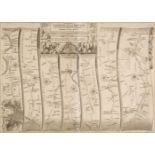
Ogilby (John). The Continuation of the Road from London to St. Davids, commencing at Abington com. Berks and extending to Monmouth, circa 1675, ha...
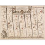
Ogilby (John). The Road from Bristol com. Gloc. to West Chester [and] The Road from the City of Salisbury com. Wilts to Campden com Gloc, circa 16...
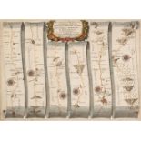
Ogilby (John). The Road from London to Buckingham Continued to Banbury in Com. Oxon. circa 1675, hand-coloured engraved strip road map, commencing...
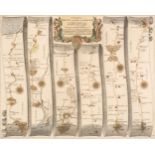
Ogilby (John). The Road from London to the City of Bristol, circa 1675, uncoloured engraved strip road map, some fraying to the vertical margins, ...
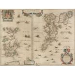
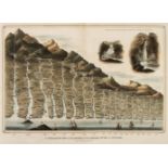
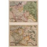
* Orkney & Shetland Islands. Blaeu (Willem Janszoon), Orcadum et Schetlandiae Insularum accuratissima descriptio, Amsterdam, circa 1650, two engra...
* Oxfordshire. Speed (John), Oxfordshire described with ye Citie and the Armes of the Colledges of yt famous University..., circa 1627, hand-colou...
* Poland. Blaeu (Guillaume & Joan), Comitatus Glatz authore Jona Sculteto, Amsterdam, circa 1640, three engraved maps with contemporary outline co...
* Poland. De Fer (N.), Les Etats de la Couronne de Pologne sous les quels sont Compris la Grande et la Petite Pologne, le Grand Duche de Lithuanie...
* Poland. Homann (Johann Baptiste, heirs of), Comitatus Glaciensis tabula..., Nuremberg, 1747, engraved map with contemporary hand colouring and s...
* Poland. Ortelius (Abraham), Poloniae Finitimarumque Locorum Descriptio Auctore Wenceslao Godreccio Polono, [1581], engraved map with contemporar...
Pomerania. De Jode (Cornelis), Pomeraniae utriusq Continentis..., [on sheet with] Thietmarsorum Simbricae Schersonesi Populorum ... [and] Prussiae...
Pomerania. Mercator (G.), Marca Brandenburgensis & Pomerania, circa 1595, engraved map of North-East Germany with contemporary hand-colouring heig...