Refine your search
Sale Section
- Antiquarian (94)
- Army Lists and Military Books from the Library of Bob Wyatt (64)
- Art and Architecture (52)
- Autographs (30)
- British Royalty and World Leaders (36)
- British Topography (13)
- Decorative and Topographical Prints (50)
- English Caricatures and Printed Satires (12)
- General Literature (11)
- General Stock (55)
- Historical Documents and Ephemera (63)
- Maps (134)
- Music Magazines (6)
- Natural History (30)
- Railways and Transport (16)
- The David Wilson Library of Natural History (Part 1) (51)
- The Leon Paul Library of Fencing (42)
- Travel & Exploration (45)
- Vinyl Records (Blues, Jazz, R&B, Rock, Classical) (40)
Estimate
Category
- Books & Periodicals (517)
- Maps (133)
- Prints (84)
- Musical Instruments & Memorabilia (46)
- Arms, Armour & Militaria (29)
- Watercolours (10)
- Taxidermy & Natural History (6)
- Bank notes (5)
- Classic Cars, Motorcycles & Automobilia (5)
- Models, Toys, Dolls & Games (5)
- Oil, Acrylic paintings & Mixed Media (5)
- Stamps (5)
- Photographs (4)
- Jewellery (3)
- Ceramics (2)
- Clocks (2)
- Coins (2)
- Collectables (2)
- Furniture (2)
- Scientific Instruments (2)
- Sporting Memorabilia & Equipment (2)
- Drawings & Pastels (1)
- Kitchenalia (1)
- Textiles (1)
- Wines & Spirits (1)
Filtered by:
- Item Type
- List
- Grid
A subscription to the Price Guide is required to view results for auctions ten days or older. Click here for more information
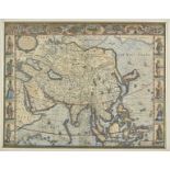

* Asia. Speed (John), Asia with the Ilands adjoyning described, the atire of the people & townes of importance, all of them newly augmented by J. ...
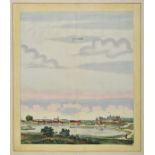
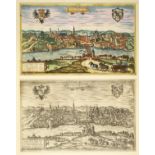
Beek (Anna). Liebenwalde & Sonnenburch, The Hague, circa 1700, two engraved town-views with contemporary hand colouring of Sonnenburg near Küstrin...
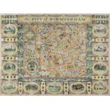
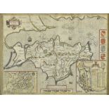
Birmingham. Price (W. H.), The City of Birmingham, 1949, large pictorial city plan, slight creasing, two small repaired marginal closed tears, 705...
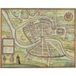
* Bristol. Braun (Georg & Hogenberg Frans), Brightstowe, [1581], engraved city plan with contemporary hand colouring, slight creasing, 345 x 435 m...
British county maps. A good mixed collection of approximately thirty maps, 17th - 19th century
British county maps. A good mixed collection of approximately thirty maps, 17th - 19th century, engraved county and strip road maps, including exa...
British county maps. A mixed collection of approximately forty maps, 17th - 19th century, engraved county and strip road maps, including examples ...
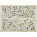
* British Islands. Mercator (Gerard & Hondius J.). Anglesey, Garnesay, Wight..., & Jarsay, 1636
* British Islands. Mercator (Gerard & Hondius J.). Anglesey, Garnesay, Wight olim vectis [and] Jarsay, [1636], four hand coloured engraved maps on...
British Isles. A collection of twelve maps, mostly 18th century, engraved maps, eleven with hand colouring, including examples by Lotter, Zannoni,...
British Isles. A mixed collection of nineteen country, regional, road and county maps, 16th - 19th century, engraved maps, including examples by S...
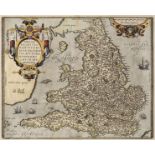
British Isles. Blaeu (Johannes), Britannia prout divisa suit temporibus Anglo-Saxonum..., circa
British Isles . Blaeu (Johannes), Britannia prout divisa suit temporibus Anglo-Saxonum praesertim durante illorum Heptarchia, Amsterdam, [1645 or ...
British Isles. Mercator (Gerard), Tab. I. Europae Continens Albion Britanniam et Hiberniam, 1690
British Isles. Mercator (Gerard), Tab. I. Europae Continens Albion Britanniam et Hiberniam, circa 1690, uncoloured engraved Ptolomaic map of the B...
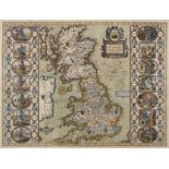
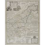
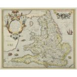
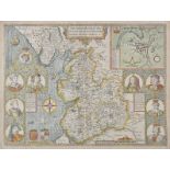
* British Isles. Speed (John), Britain as it was devided in the tyme of the Englishe Saxons especially during their Heptarchy, Thomas Bassett & Ri...
British Isles. Speed (John), Britain as it was devided in the tyme of the English Saxons..., 1627
British Isles. Speed (John), Britain as it was devided in the tyme of the English Saxons especially during their Heptarchy, John Sudbury & George ...
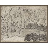
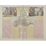
* British Isles. Speed (John), The Invasions of England and Ireland with al their Civill Wars since the Conquest, George Humble, circa 1627, hand ...
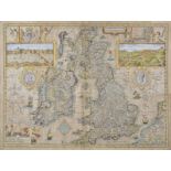
British Isles. Speed (John), The Kingdom of of Great Britaine and Ireland, Thomas Bassett & Richard Chiswell, [1676], hand coloured engraved map, ...
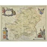
* Buckinghamshire. Speed (John), Buckingham both Shyre and Shire towne described, George Humble, circa 1627, hand coloured engraved map, inset tow...
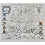
* Cambridgeshire. Blaeu (J.), Cantabrigiensis comitatus, Cambridge Shire, Amsterdam, circa 1645, hand coloured engraved map, the vertical margins ...
* Cambridgeshire. Speed (John), Cambridgshire described with the devision of the hundreds, the Townes situation, with the of the Colleges of that ...
Canal Maps. Bradshaw (G.), G. Bradshaw's Map of Canals, Navigable Rivers, Rail Roads &c. of the Midland Counties of England from actual survey she...
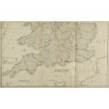
Cary (John). Cary's New and Correct English Atlas: Being a New Set of County Maps from Actual Surveys..., 1st edition, printed for John Cary, Engr...
Cary (John). Six county maps, 1801 and later, six large engraved maps with contemporary hand colouring, oval cartouche, each approximately 545 x 4...
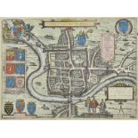
* Chester. Braun (Georg & Hogenberg Frans), Cestria (vulgo) Chester Angliae Civitas, [1581], hand coloured engraved city plan, 325 x 440 mm, mount...
Devon. Blaeu (Johannes), Devonia vulgo Devon-Shire, [1645 or later], engraved map with contemporary outline colouring, 395 x 505 mm, German text o...
Devon. Jansson (Jan), Devoniae Descriptio. The Description of Devon-Shire, Amsterdam, circa 1650, engraved map with contemporary outline colouring...
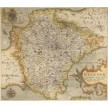
* Devonshire. Saxton Christopher & Kip William), Devoniae comitatus vuldo Denshyre quam olim Danmonii Populi Incolouerunt, [1637], hand coloured e...
Dorset. Blaeu (Johannes), Comitatus Dorcestria sive Dorsettia; vulgo Anglice Dorset Shire, 1660
Dorset. Blaeu (Johannes), Comitatus Dorcestria sive Dorsettia; vulgo Anglice Dorset Shire, circa 1660, engraved map with contemporary outline colo...
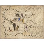
Drayton (Michael). Two untitled allegorical maps of Middlesex and Hertfordshire and of Anglesey and Caernarvonshire circa 1622, two hand coloured ...
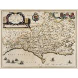
Drayton (Michael). Allegorical map of Hampshire & Dorset, [1612 or later], hand coloured engraved allegorical map of Dorset, Hampshire and the Isl...
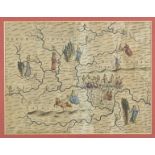
* Drayton (Michael). Two allegorical maps, [1612 or later], two hand coloured engraved allegorical maps, one showing parts of Oxfordshire, Bucking...
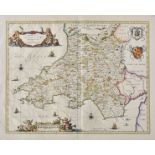
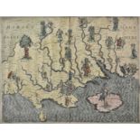
* Drayton (Michael). Untitled allegorical map of South Wales and North Somerset, circa 1622, uncoloured engraved allegorical map of the north and ...
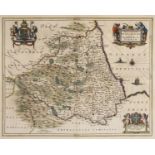
Durham. Jansson (Jan), Episcopatus Dunelmensis vulgo The Bishoprike of Durham, Amsterdam, circa
Durham. Jansson (Jan), Episcopatus Dunelmensis vulgo The Bishoprike of Durham, Amsterdam, circa 1650, engraved map with contemporary outline colou...
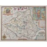
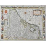
Durham. Speed (John), The Bishoprick and Citie of Durham, Thomas Bassett & Richard Chiswell, [1676], hand coloured engraved map, inset town plan o...
England & Wales. Chatelain (Henry Abraham), Four maps of the British Isles, circa 1720, including Nouvelle carte du Gouvernement civil D'Angleterr...
England & Wales. Ortelius (Abraham & Lhuyd Humphrey), Angliae Regni Florentissimi..., circa 1601
England & Wales. Ortelius (Abraham & Lhuyd Humphrey), Angliae Regni Florentissimi nova descriptio auctore Humfredo Lhuyd Denbygiense, [1601], hand...
* England & Wales. Ortelius (Abraham), Angliae Regni Florentissimi nova descriptio auctore Humfredo Lhuyd Denbygiense, [1573], hand coloured engra...
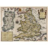
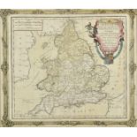
England & Wales. Rocque (John), England and Wales drawn from the most accurate surveys, Containing all the Cities, Boroughs, Market Towns and Vill...
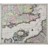
English Channel. Seutter (Matthäus), La plus grande partie de la Manche, qui contient les côtes D'Angleterre et celles de France, les Bords Mariti...
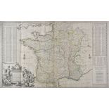
France. Moll (H), A New and Exact Map of France divided into all its Provinces and Acquisitions according to the newest observations..., D. Midwin...
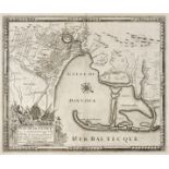
Gdansk/Danzig. De Fer (Nicolas & Danet G.), Plan de Dantzick avec ces Nouvaux Ouvrages Ville de Prusse..., Paris, circa 1734, uncoloured engraved ...
* Germany. Braun (Georg & Hogenberg, Franz). Gorlitz, Cologne, circa 1575, engraved city plan with contemporary hand colouring, 305 x 500 mm, moun...
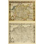
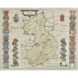
* Germany. Speed (John), A Newe Mape of Germany, newly augmented, Thomas Bassett & Richard Chiswell [1676], hand coloured 'carte-a-figures' map of...
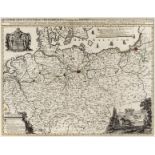
Germany/Prussia. Halma (Francois), Regni Borussiae et Electoratus Brandeburgici.., circa 1700
Germany/Prussia. Halma (Francois), Regni Borussiae et Electoratus Brandeburgici, Ceterarumque, Quae Friderici, Regis Boruss. sceptro reguntur, nec...
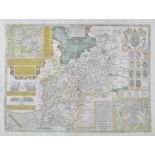
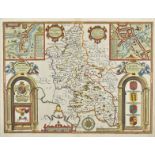
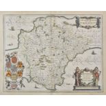
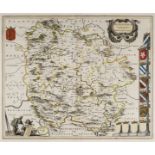
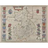
Gloucestershire. Speed (John), Glocestershire contrived into thirty thre severall hundreds & those againe into foure principall devisions. The cit...
* Gloucestershire. Speed (John), Glocestershire contrived into thirty thre severall hundreds & those againe into foure principall devisions. The c...
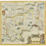
Hampshire. Blaeu (Johannes), Hantonia sive Southantonensis comitatus vulgo Hantshire, circa 1645
Hampshire. Blaeu (Johannes), Hantonia sive Southantonensis comitatus vulgo Hantshire, circa 1645, hand coloured engraved map, 415 x 505 mm, Latin ...
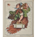
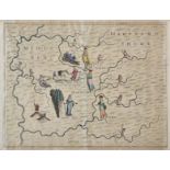
Harvey (William Henry 'Aleph'). Geographical Fun: being Humourous Outlines of various Countries..., Hodder and Stoughton, circa 1868, additional h...
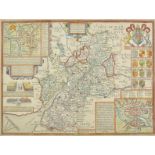
Herefordshire. Blaeu (Johannes), Herefordia Comitatus Hereford-Shire, circa 1650, engraved map with contemporary outline colouring, several repair...
* Hertfordshire. Blaeu (Johannes), Hertfordia comitatus vernacule Hertfordshire, Amsterdam, circa 1645, engraved map with contemporary hand colour...
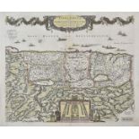
Holy Land. De Wit (Frederick), Terra Sancta sive promissionis olim Palestina recens delineata..., Amsterdam, circa 1680, engraved map with contemp...
* Isle of Wight. Speed (John), Wight Island, John Sudbury & George Humble, circa 1627, hand coloured engraved map, inset town plans of Newport and...
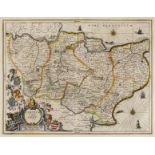
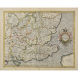
Kent. Jansson (Jan), Cantium vernacule Kent, Amsterdam, circa 1650, hand coloured engraved map, large decorative cartouche, compass rose and numer...
Lancashire. Blaeu (Johannes), Lancastria Palatinatus Anglis Lancaster et Lancasshire, circa 1645
Lancashire. Blaeu (Johannes), Lancastria Palatinatus Anglis Lancaster et Lancasshire, circa 1645, hand coloured engraved map, large decorative car...
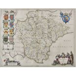
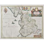
Lancashire. Speed (John), The Countie Palatine of Lancaster described and divided into Hundreds, Thomas Bassett & Richard Chiswell, [1676], hand c...
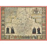
Low Countries. Speed (John), A New Mape of ye XVII Provinces of Low Germanie, Thomas Bassett & Richard Chiswell, [1676], hand coloured engraved 'c...
* Maps and prints. A collection of six engraved maps and prints, mostly 19th century, including Brion de la Tour (Louis). L'Angleterre divisée en ...
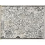
Maps. A mixed collection of approximately ninety maps, mostly 19th century, engraved and lithographic county maps, London ward plans, town plans a...
Maps. A mixed collection of approximately ninety maps, mostly 19th century, engraved and lithographic county and regional maps and town plans, inc...
Mercator (Gerard & Hondius H.). Four regional maps of England and Wales, 1595 or later, four hand coloured engraved regional maps of the South Eas...
* Middlesex. Blaeu (Johannes), Middle-Sexia , circa 1645, engraved map with contemporary hand colouring, 395 x 405 mm, mounted, framed and glazed,...
Middlesex. Drayton (Michael), Untitled allegorical map of Middlesex and Hertfordshire, circa 1612
Middlesex. Drayton (Michael), Untitled allegorical map of Middlesex and Hertfordshire, [1612 or later], hand coloured engraved allegorical map ver...