Refine your search
Sale Section
- Art Reference (8)
- Books from the Library of Michael Jaffé (39)
- British Topography (15)
- Decorative Prints and Original Art (30)
- Early Printed Books, Theology and Literature (104)
- English Literature and Poetry from the Library of Jonathan Wordsworth (18)
- General Literature (10)
- Italian Renaissance Literature from the Library of Cecil Clough (78)
- Maps (65)
- The Leonard Channing Bible Collection (43)
Estimate
Category
Filtered by:
- Item Type
- List
- Grid
A subscription to the Price Guide is required to view results for auctions ten days or older. Click here for more information

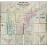
Africa. A mixed collection of approximately 65 maps, 18th & 19th century, engraved and lithographic maps of regions, countries, the continent and ...
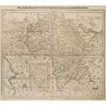
Africa. Munster (Sebastian), Africa Lybia Morenlandt mit allen Koenigreichen so jetziger eit darumb gefunden werden, [1580 or later], uncoloured w...
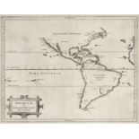
* Americas. De Laet (Joannes), Americae sive Indiae Occidentalis Tabula Generalis, Leiden, circa 1630, uncoloured engraved map, one printer's fold...
* Americas. De L'Isle (Guillaume), Carte d 'Amerique... , Paris, 1722, engraved map with contemporary outline colouring, slight toning, 490 x 610 ...
* Americas. Homann (Johann Baptiste, Heirs of), Americae Mappa Generalis Secundum Legitimas Projectionis Stereographicae Regulas ... Concinnata et...
![* Americas. Munster (Sebastian), Americae sive novi orbis..., [1588 - 1628]](https://portal-images.azureedge.net/auctions-2019/srdom10136/images/538dffac-8093-45ca-b604-aab90114c8a2.jpg?w=155&h=155)
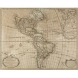
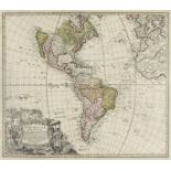
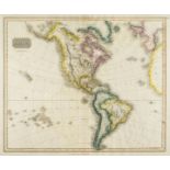
* Americas. Munster (Sebastian), Americae Sive Novi Orbis Nova Descriptio, Basle, [1588-1628], hand coloured wood block map of north and south Ame...
![Blome (Richard). A collection of ten county maps. [1673]](https://portal-images.azureedge.net/auctions-2019/srdom10136/images/570f5644-2384-44b3-afde-aab90114cc5a.jpg?w=155&h=155)
Blome (Richard). A collection of ten county maps. [1673], ten uncoloured engraved county maps, one map (Norfolk) with some staining, one map dupli...
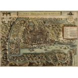
Braun ( Georg & Hogenberg Frans ). Rimini, Tornacum [and] Aurelia Franciae Civitas ad Ligeri Flv: sita, circa 1590, together three hand coloured e...
![Bristol. Braun (Georg & Hogenberg Frans), Brightstowe [1581 or later]](https://portal-images.azureedge.net/auctions-2019/srdom10136/images/61c0a9d5-9a0b-43c5-9e1d-aab90114d49c.jpg?w=155&h=155)
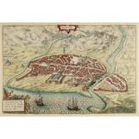
Bristol. Braun ( Georg & Hogenberg Frans ), Brightstowe [1581 or later], hand coloured engraved map, slight spotting largely confined to margins, ...
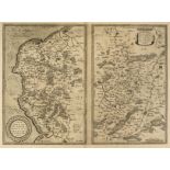
British County Maps. A mixed collection of approximately 200 maps, 17th - 19th century, engraved county maps and road maps, mostly uncoloured, wit...
British County Maps. A mixed collection of approximately 200 maps, 18th & 19th century, engraved county maps and road maps, comprising of examples...
British county maps. A mixed collection of twenty-nine maps, 18th & 19th century, engraved hand coloured maps including thirteen county maps by E....
![* British Isles. Blaeu (G.), Magnae Britanniae..., [1631 or later],](https://portal-images.azureedge.net/auctions-2019/srdom10136/images/6822b0da-16bc-4932-aa41-aab90114dfbb.jpg?w=155&h=155)
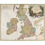
* British Isles. Blaeu (Guillaume), Magnae Britanniae et Hiberniae tabula, Amsterdam, [1631 or later], engraved map with contemporary outline colo...
British Isles. De Vaugondy (Gilles Robert), Carte des Grandes Routes D'Angleterre, D'Ecosse et D'Irlande, circa 1778, hand coloured engraved map, ...
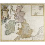
British Isles. Homann (Johann Baptiste, Heirs of), Magna Britannia complectens Angliae, Scotiae et Hyberniae..., circa 1730, engraved map with con...
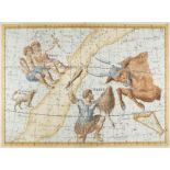
Celestial charts. Bode (Johann Elbert), Corvus & Centaurus, plate XIX, Cassiopeja, Perseus and Andromeda, plate IV & Gemini, Orion and Taurus, pla...
China. Dorn (Frank), A map and history of Peiping: formerly known as Peking..., 1st edition, Peiyang Press Ltd., Peiping, 1936, colour lithographi...
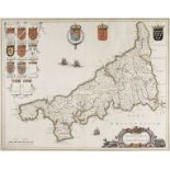
Cornwall. Blaeu (Johannes), Cornubia sive Cornwallia, Amsterdam, circa 1645, hand coloured engraved map, slight text show-through, slight creasing...
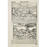
Cyprus. Munster (Sebastian), Cyprus, Basel, circa 1550, uncoloured woodblock map with a panel below the map showing a leaping stag and a sheep dri...
![Drayton (Michael), A collection of 10 maps [1612 or later],](https://portal-images.azureedge.net/auctions-2019/srdom10136/images/63982747-2505-40cb-887d-aab90114e9ad.jpg?w=155&h=155)
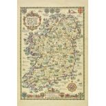
Drayton (Michael). A collection of 10 maps [1612 or later], ten uncoloured allegorical maps, one map (Isle of Ely) trimmed and laid on later paper...
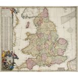
England & Wales. De Ram (Jan), Regni Angliae nova tabula Pricipatum Walliae & Aliraum Provincia ..., Amsterdam R. & I. Ottens , [1756], engraved m...
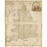
England & Wales. Rocque (John), England and Wales drawn from the most accurate Surveys containing all the Cities, Boroughs, Market Towns & Village...
Foreign maps. A collection of approximately 120 maps, 18th & 19th century, engraved and lithographic county and regional maps and town plans, incl...
Foreign Maps. A mixed collection of approximately 90 maps, 18th century, engraved maps of countries, regions and town plans, with examples by Bonn...
France. A collection of approximately 45 maps, mostly 18th & 19th century, engraved and lithographic regional and country maps, including examples...
Germany and Eastern Europe. A mixed collection of 58 maps, 18th & 19th century, engraved maps of Germany, Poland, Silesia and Hungary, including e...
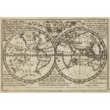
Gibson (John & Bowen Emanuel). Atlas Minimus or a New Set of Pocket Maps of the Several Empires, Kingdoms and States of the known World, with Hist...
Glamorganshire. Saxton (Christopher & Webb William), Glamorg? comitatus australis Cambriae pars descriptio, 1642, uncoloured engraved map, lower m...
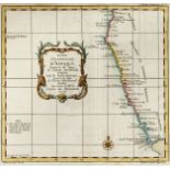
India and the East Indies. A mixed collection of approximately 50 maps, 18th & 19th century, engraved and lithographic country maps, regional maps...
Ireland. Taylor (A. E.), Pratts High Test Plan of Ireland, 1933, pictorial colour photo-lithographic map, descriptive text by S. P. B. Mais on ver...
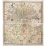
London. Stanford's Map of Modern London and the Suburbs, Edward Stanford, [1878], large engraved map with bright contemporary hand colouring, sect...
* Maps and prints. A collection of approximately 140 maps and prints, mostly 18th & 19th century, including approximately forty engraved county ma...
Maps . A mixed collection of approximately 300 maps, mostly 19th century, engraved and lithographic maps, mostly of British counties and regions, ...
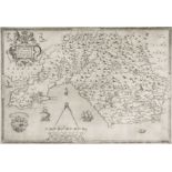
Maps. A mixed collection of seven maps, mostly 17th & 18th century, including Speed (John). Merionethshire Described, George Humble, [1627], hand ...
Middle East, Turkey in Asia and the Holy Land. A collection of approximately 48 maps, mostly 19th century, engraved and lithographic country and r...
Moll (Herman), Bowles's Atlas Minor; Containing a new and curious set of Sixty-five maps..., 1781,
Moll (Herman). Bowles's Atlas Minor; Containing a new and curious set of Sixty-five maps in which are shewn all the Empires, Kingdoms, Countries, ...
![Morden (Robert). A collection of approximately 75 maps, [1701 or later],](https://portal-images.azureedge.net/auctions-2019/srdom10136/images/a739c056-a34d-4846-9920-aab90114f3ec.jpg?w=155&h=155)
Morden (Robert). A collection of approximately 75 maps, [1701 or later], uncoloured engraved county and regional maps from the 'miniature Morden' ...
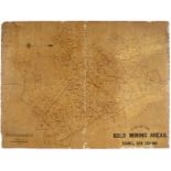
New Zealand. Plan of the Gold Mining Areas, Thames, New Zealand, Surveyor H. Kendrick, Auckland, Wilsons & Horton, circa 1886, lithographic map, s...
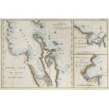
New Zealand. Riviere Tamise et B'Aye Mercure a la Nle. Zelande, circa 1774, three hand coloured engraved maps on one sheet (as published), some wa...
North America & Canada. A mixed collection of approximately 110 maps 19th century, engraved and lithographic state, regional and country maps, inc...
Oceania. A mixed collection of 60 maps, 19th century, engraved and lithographic maps of Australia, New Zealand and Polynesia, with examples by Arr...
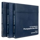
Papadopoulos (Christos). True Visual Magnitude Photographic Star Atlas, 3 volumes, Volume 1 Southern Stars, Volume 2 Equatorial Stars & Volume 3 N...
![Persia. Ortelius (Abraham), Persici sive Sophorum Regni Typus, [1612],](https://portal-images.azureedge.net/auctions-2019/srdom10136/images/e0dbbf7e-0e91-4250-b15a-aab90114f813.jpg?w=155&h=155)
Persia. Ortelius (Abraham), Persici sive Sophorum Regni Typus, [1612], engraved map with contemporary hand colouring, slight offsetting, some oxid...
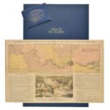
River Thames. Palmer (Francis L.), To Accompany Mr. Palmer's Pamphlet on the Thames Floods, The Tower Bridge & to Illustrate the Tourist's Table. ...
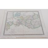
Russia & Europe. A mixed collection of approximately 40 maps, mostly 19th century, engraved and lithographic maps of regions and countries, with e...
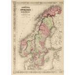
Scandinavia, Belgium and Holland. A collection of approximately 48 maps, mostly 19th century, engraved and lithographic county and regional maps a...
![Scotland & Ireland. Perrot (A. M.). A collection of 39 maps, [1834],](https://portal-images.azureedge.net/auctions-2019/srdom10136/images/61db622b-10a3-4dac-8f59-aab90114fb11.jpg?w=155&h=155)
Scotland & Ireland. Perrot (A. M.). A collection of 39 maps, [1834], engraved miniature maps of Scottish and Irish counties, all with contemporary...
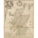
Scotland. Elphinstone (John), A New & Correct Mercator's Map of North Britain, Carefully Laid down from the Latest Surveys and Most Approved Obser...
![Scotland. Porcacchi (Tomaso), Isole Hebride et Orcade, [1713],](https://portal-images.azureedge.net/auctions-2019/srdom10136/images/6de0089f-8a42-4e5e-adb5-aab90114fd02.jpg?w=155&h=155)
Scotland. Porcacchi ( Tomaso ), Isole Hebride et Orcade, [1713], uncoloured engraved map, Italian and French text above, below and on verso of map...
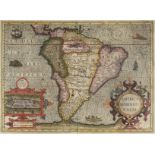
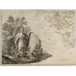
* South America. Mercator (Gerard), America Meridionalis, circa 1610, engraved map with bright contemporary hand colouring, inset view of Cuzco, l...
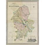
Staffordshire. Phillips (J. & Hutchings W.F.), A Map of the County of Stafford, Divided into Hundreds & Parishes from an accurate Survey, made in ...
The Map Collector, numbers 1 - 74 (complete), December 1977 - Spring 1996, numerous colour and black & white illustrations throughout, all with or...
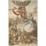
Atlas Title Pages. Six folio title pages, mostly 17th century, six hand coloured engraved title pages, including examples by De Bry, J & W Blaeu, ...
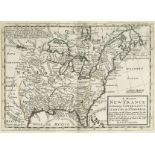
United States. Blanchard (Rufus), Historical Map of the United States Showing Early Spanish, French and English Discoveries and Explorations, also...
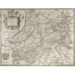
![Wales. Bill (John), Glamorganshire, Montgomerie [and] Brecknockshire, [1626]](https://portal-images.azureedge.net/auctions-2019/srdom10136/images/9ae296e4-3a89-484b-9b43-aab901150013.jpg?w=155&h=155)
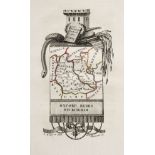
Wales. Bill (John), Glamorganshire , Montgomerie [and] Brecknockshire , [1626], together three engraved maps, Glamorgan with sparse outline colour...
Wales. Saxton (Christopher & Webb William), Radnor , Breknock Cardigan et Caermarden, quatuor australis Cambriae comitatuum..., 1642, uncoloured e...
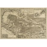
West Indies and South America. A mixed collection of approximately 50 maps, 18th & 19th century
West Indies and South America. A mixed collection of approximately 50 maps, 18th & 19th century, engraved and lithographic regional and country ma...
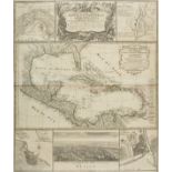
* West Indies. Homann (Johann Baptiste, Heirs of), Mappa Geographica, Complectens I. Indiae Occidentalis Partem Mediam Circum Isthmum Panamensem I...
Wiltshire. A collection of five county maps, 17th - 19th century, engraved maps including examples by Van den Keere, Tunnicliff, Cary, Pigot and M...
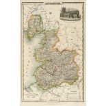
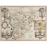
Wiltshire. Andrews (John & Dury Andrew), A Topographical Map of Wiltshire on a Scale of 2 inches to a mile from an Actual Survey by John Andrews &...