Filtered by:
- Category
- List
- Grid
This auctioneer has chosen to not publish their results. Please contact them directly for any enquiries.
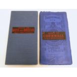

Two early 20thC Bartholomew?s maps, New Reduced Survey for Tourists and Cyclists, mounted on
Two early 20thC Bartholomew?s maps, New Reduced Survey for Tourists and Cyclists, mounted on cloth, 2" to 1 mile. To include Sheet 28 Bath, and Sh...
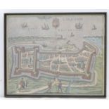
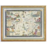
Map: a framed, hand-coloured view of Calais (contemporarily produced after Braun and Hogenberg
Map: a framed, hand-coloured view of Calais (contemporarily produced after Braun and Hogenberg 1597), 12 7/8" x 15 3/4"Please Note - we do not ma...
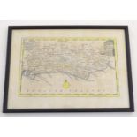
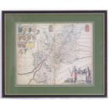
An 18thC hand coloured map of Sussex engraved by Thomas Kitchin (1718-1784) and published in Henry
An 18thC hand coloured map of Sussex engraved by Thomas Kitchin (1718-1784) and published in Henry Boswell's atlas Antiquities of England & Wales....
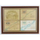
Four prints / maps framed together relating to the St Lawrence River and Seaway, Home waters to
Four prints / maps framed together relating to the St Lawrence River and Seaway, Home waters to the MV Canadian Empress cruise ships. Approx. 23" ...
After Gerardus Mercator (1512-1594), A 20thC decorative map depicting part of the Mediterranean,
After Gerardus Mercator (1512-1594), A 20thC decorative map depicting part of the Mediterranean,circa 1600. To include Africa Barbaria, the Africa...
After Joan Blaeu (1596-1673), Coloured map of Gloucestershire, Glocestria Decatus Vulgo Glocester.
After Joan Blaeu (1596-1673), Coloured map of Gloucestershire, Glocestria Decatus VulgoGlocester. The upper left corner with twelve shields, ten f...