Filtered by:
- Category
4 items
- List
- Grid
This auctioneer has chosen to not publish their results. Please contact them directly for any enquiries.

Lot 685
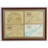
Four prints / maps framed together relating to the St Lawrence River and Seaway, Home waters to
Four prints / maps framed together relating to the St Lawrence River and Seaway, Home waters to the MV Canadian Empress cruise ships. Approx. 23" ...
Lot 1220A
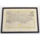
An 18thC hand coloured map of Sussex engraved by Thomas Kitchin (1718-1784) and published in Henry
An 18thC hand coloured map of Sussex engraved by Thomas Kitchin (1718-1784) and published in Henry Boswell's atlas Antiquities of England & Wales....
Lot 1235A
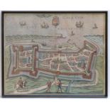
Map: a framed, hand-coloured view of Calais (contemporarily produced after Braun and Hogenberg
Map: a framed, hand-coloured view of Calais (contemporarily produced after Braun and Hogenberg 1597), 12 7/8" x 15 3/4"Please Note - we do not ma...
Lot 1242A
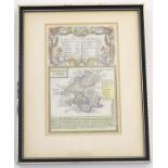
A double glazed 18thC hand coloured map of Pembrokeshire by John Ogilby, published in Owen & Bowen's
A double glazed 18thC hand coloured map of Pembrokeshire by John Ogilby, published in Owen & Bowen's pocket road atlas, Britannia Depicta, or Ogil...