Filtered by:
- Category
4 items
- List
- Grid
A subscription to the Price Guide is required to view results for auctions ten days or older. Click here for more information
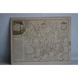

Lot 189
EMANUEL BOWEN - "AN ACCURATE MAP OF THE COUNTY OF WORCESTER", original map from the Large English
189EMANUEL BOWEN - "AN ACCURATE MAP OF THE COUNTY OF WORCESTER", original map from the Large English
EMANUEL BOWEN - "AN ACCURATE MAP OF THE COUNTY OF WORCESTER", original map from the Large English Atlas, c.1760, a very detailed map with later ha...
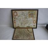
Lot 190
JOHN SPEED MAP OF WORCESTERSHIRE c.1676, with later hand colouring, possibly laid down but not
JOHN SPEED MAP OF WORCESTERSHIRE c.1676, with later hand colouring, possibly laid down but not inspected out of frame 43 x 56 cm (inc. frame) toge...
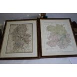
Lot 191
AN 1836 J AND C WALKER MAP OF STAFFORDSHIRE, together with a an E. Weller map of Shropshire both
AN 1836 J AND C WALKER MAP OF STAFFORDSHIRE, together with a an E. Weller map of Shropshire both framed and glazed 45 cm x 55 cm including frames

AN ORIENTAL STYLE VASE, NO MARKS, H 45.5 CM¦Condition Report:Various repairs to the rim¦ ...[more]