
Filtered by:
- Category
- List
- Grid
A subscription to the Price Guide is required to view results for auctions ten days or older. Click here for more information
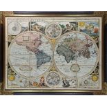

John Speed (British, 1552-1629), "A New and Accurat Map of the World Drawne according to ye truest
John Speed (British, 1552-1629), "A New and Accurat Map of the World Drawne according to ye truest Descriptions lastest Discoveries & best observa...
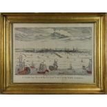
John Carwitham (American/British, 1723-1741), "A South-East View of the City of Boston in North
John Carwitham (American/British, 1723-1741), "A South-East View of the City of Boston in North America," hand-colored engraving, published by Bow...
Copper engraved map with hand-coloring, "Carte du Lac de Mexico," overall (with frame): 16.25"h x
Copper engraved map with hand-coloring, "Carte du Lac de Mexico," overall (with frame): 16.25"h x 13.5"w
Copper engraved map, "Penn, Boquette," 1876, from the Westmoreland County Pennsylvania Atlas,
Copper engraved map, "Penn, Boquette," 1876, from the Westmoreland County Pennsylvania Atlas, published by Reading Publishing Co., overall (with f...
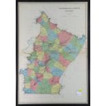
(lot of 2) Westmoreland and Fayette Counties, published by Julius Bien & Co. (New York, NY), and
(lot of 2) Westmoreland and Fayette Counties, published by Julius Bien & Co. (New York, NY), and Rolling Rock Area, lithographic Maps in colors, o...
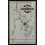
Lithographic map, "Interurban Lines of the Pittsburgh Railways Company and Connecting Lines,"
Lithographic map, "Interurban Lines of the Pittsburgh Railways Company and Connecting Lines," 1953, published by the Pennsylvania Railway Museum, ...
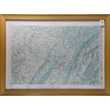
Plastic Relief Map in colors, "Pittsburgh, Pennsylvania," prepared by the Army Map Service (AM),
Plastic Relief Map in colors, "Pittsburgh, Pennsylvania," prepared by the Army Map Service (AM), Corps of Engineers, U.S. Army, Washington, D.C. C...
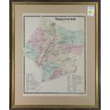
Hand-colored copper engraved map, "Wallingford, Connecticut," 1868, from F.W. Beers Atlas of New
Hand-colored copper engraved map, "Wallingford, Connecticut," 1868, from F.W. Beers Atlas of New Haven County, Connecticut, overall (with frame): ...
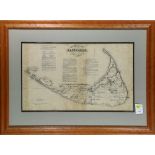
The Rev. Ferdinand Cartwright Ewer (American, 1826-1883), "Historical Map of Nantucket," originally published in 1869 to promote the "Old Colony L...
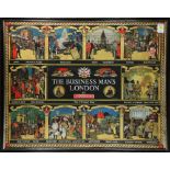
After Richard T. Cooper (British, 1884-1957), "The Business Man's London," 1977, screenprint in
After Richard T. Cooper (British, 1884-1957), "The Business Man's London," 1977, screenprint in colors, plate signed right/center, originally crea...
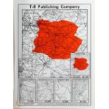
(lot of 2) Pittsburgh, Pennsylvania Tribune Review Maps, each highlighting specific areas corresponding to circulation numbers, each undated, larg...
(lot of 5) American School (19th century), Four business directory maps of Mt. Pleasant, Latrobe,
(lot of 5) American School (19th century), Four business directory maps of Mt. Pleasant, Latrobe, Parnassus, and West Newton , 1876, engravings wi...
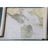
(lot of 4) San Francisco Entrance (1937) San Pablo Bay (1934), San Francisco Bay; Candlestick
(lot of 4) San Francisco Entrance (1937) San Pablo Bay (1934), San Francisco Bay; Candlestick Point to Angel Island (1941- not reissued) Survey Ma...
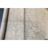
(lot of 6) (3) San Joaquin River (1933/1936), Sacramento River (1926), Suisun Bay (1935), and
(lot of 6) (3) San Joaquin River (1933/1936), Sacramento River (1926), Suisun Bay (1935), and Pfeiffer Point to Cypress Point (1935) Survey Maps, ...
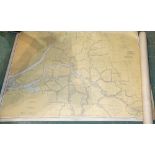
(lot of 4) San Joaquin River (1936), San Francisco: Candlestick Point to Angel Island (1937), Suisun
(lot of 4) San Joaquin River (1936), San Francisco: Candlestick Point to Angel Island (1937), Suisun Bay (1935), and Mare Island Strait (1939) Sur...