- List
- Grid
A subscription to the Price Guide is required to view results for auctions ten days or older. Click here for more information
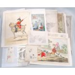

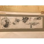
Satirical cartoons after Gillray and others, some with later hand colour, including - Progress of
Satirical cartoons after Gillray and others, some with later hand colour, including - Progress of the Toilet, plates I & II; Brigade Major 1797; H...
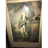
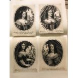
Bartolozzi after Russell, The Prince of Wales, 'To The Royal Kentish Bowmen', coloured stipple
Bartolozzi after Russell, The Prince of Wales, 'To The Royal Kentish Bowmen', coloured stipple engraving published 1795 by John Jeffreys, trimmed,...
![William Hogarth, The Enraged Musician, engraving 1741 [or later], 36 x 41cm (plate); and 'Times of](https://portal-images.azureedge.net/auctions-2018/srche10146/images/7ba2e291-7d1a-4cbd-a29c-cde049f1cd4c.jpg?w=155&h=155)
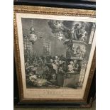
William Hogarth, The Enraged Musician, engraving 1741 [or later], 36 x 41cm (plate); and 'Times of
William Hogarth, The Enraged Musician, engraving 1741 [or later], 36 x 41cm (plate); and 'Times of Day', three (of four) engravings also after Hog...
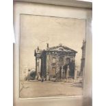
Sir William Nicholson (British, 1872-1949) Entrance to the Bodleian Library, Oxford, signed lower
Sir William Nicholson (British, 1872-1949) Entrance to the Bodleian Library, Oxford, signed lower left "Nicholson", lithograph, 32 x 26cm; Soldier...
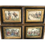
Martinus vanden Enden, Two small later-coloured engravings of amorous subjects; with two others of
Martinus vanden Enden, Two small later-coloured engravings of amorous subjects; with two others of similar size, in parcel gilt frames, c.18 x 23c...
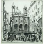
Geoffrey Heath Wedgwood (1900 - 1977), St Peter's Genoa II, etching, inscribed below in pencil and
Geoffrey Heath Wedgwood (1900 - 1977), St Peter's Genoa II, etching, inscribed below in pencil and dated '50, 26 x 25cm (10 x 10in) ...[more]
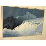
Oscar Droege (Austrian, 1898-1982), Mountainous scene, colour woodcut, signed, 25 x 37cm ...[more]
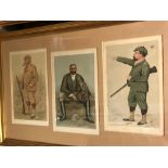
Spy and similar Caricatures of Sportsmen, a group of twenty-one coloured prints, three to a frame,
Spy and similar Caricatures of Sportsmen, a group of twenty-one coloured prints, three to a frame, and two others (23 prints) ...[more]
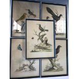
George Edwards (1694-1773), a set of five hand-coloured engravings of birds, including The Red-
George Edwards (1694-1773), a set of five hand-coloured engravings of birds, including The Red-Breasted Black-Bird from Surinam, Birds and Insects...
Gustave Dore, a large collection of mounted illustrations, mainly cut from 19th century French
Gustave Dore, a large collection of mounted illustrations, mainly cut from 19th century French periodicals, housed in 5 large folders; together wi...
HAMILTON (William R.) Atlas volume only to Remarks on Several Parts of Turkey, London 1809-10,
HAMILTON (William R.) Atlas volume only to Remarks on Several Parts of Turkey, London 1809-10, folio, 58 x 43cm, with map of Egypt and 24 plates a...
HAMILTON (Gavin) Schola Italica Picturae sive selectae quaedam summorum a schola italica pictorum
HAMILTON (Gavin) Schola Italica Picturae sive selectae quaedam summorum a schola italica pictorum tabulae aere incisae, Rome, 1771, folio, 587 x 4...
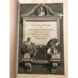
HAMILTON (Gavin) Schola Italica Picturae sive selectae quaedam summorum a schola italica pictorum
HAMILTON (Gavin) Schola Italica Picturae sive selectae quaedam summorum a schola italica pictorum tabulae aere incisae, Rome, 1731, folio, 61 x 41...
The Kalender of Shepherdes', six mounted woodcuts from an English 16th century edition, with text to
The Kalender of Shepherdes', six mounted woodcuts from an English 16th century edition, with text to verso; together with other unframed wood engr...
Robert Walker Macbeth, Folder of proof and other prints, some signed, with others by William Strang etc., condition and sizes vary ...[more]
George Cuitt (British 1779-1854), Collection of loose topographical etchings, large paper, including
George Cuitt (British 1779-1854), Collection of loose topographical etchings, large paper, including abbeys, cottages etc., and some wrappers; als...
A collection of etched costume plates after Jacquemin, printed by Delatre, Paris, loose; together
A collection of etched costume plates after Jacquemin, printed by Delatre, Paris, loose; together with assorted others, 19th century (quantity) ...
A folder of etchings and engravings, including works by or after Stefano Della Bella, John Thomas
A folder of etchings and engravings, including works by or after Stefano Della Bella, John Thomas Smith, T. Cruger, Callot, etc, subjects and cond...
After Alonso Chacon, a collection of mounted Roman triumphal friezes, engravings from Trajan's
After Alonso Chacon, a collection of mounted Roman triumphal friezes, engravings from Trajan's Column, from the work by Alonso Chacon, published R...
Collection of loose engravings and etchings, mainly portrait busts, including after Pierre Lombart; eight trimmed mounted busts of Caesars, etc ...
A folder of loose and mounted prints and engravings, 17th century and later, including after Old
A folder of loose and mounted prints and engravings, 17th century and later, including after Old Masters, landscapes, religious subjects, all in v...
A pair of engravings of Views of Cairo by Berthault after drawings by Duletre entitled "Le Kaire",
A pair of engravings of Views of Cairo by Berthault after drawings by Duletre entitled "Le Kaire", plates 42 and 45 from the first volume of the "...
William Hogarth, Credulity, Superstition and Fanaticism, a Medley, Engraving 1762, a good impression, within a moulded ebonised and gilt wood fram...
William Woollett after George Stubbs, The Spanish Pointer, stipple engraving published by R H
William Woollett after George Stubbs, The Spanish Pointer, stipple engraving published by R H Laurie, 58 x 69.5cm (sheet; good margins) ...[mor...
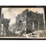
Giovanni Battista Piranesi, Tempio detto Volgarmente di Giano Etching, 49 x 72cm ...[more]
Captain William Baillie after Rembrandt, Three Trees with Lightning, etching, 21 x 28cm ...[more]
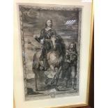
Pierre Lombart after Van Dyck, Oliver Cromwell on horseback with an attendant, engraving, 55.5cm x
Pierre Lombart after Van Dyck, Oliver Cromwell on horseback with an attendant, engraving, 55.5cm x 35cm (plate), slight damage to some margins. N...
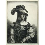
Gerald Leslie Brockhurst (1890 - 1978), The Black Silk Dress, etching, signed in pencil lower right,
Gerald Leslie Brockhurst (1890 - 1978), The Black Silk Dress, etching, signed in pencil lower right, CCA Gallery label verso 22.50 x 16cm (9 x 6in...
Robert Sayer, publisher, four 18th century coloured engravings: Greenwich Hospital after Sir Christopher Wren, West View of London after Canaletto...
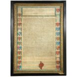
MAGNA CARTA, a facsimile engraved by John Pine, a copy of King John's Great Charter with 25 coloured
MAGNA CARTA, a facsimile engraved by John Pine, a copy of King John's Great Charter with 25 coloured shields to both long borders, marked at the f...
![David Loggan, Corpus Christi College [Oxford], 17th century double page engraving, 42 x 53cm;](https://portal-images.azureedge.net/auctions-2018/srche10146/images/2bf79d35-ae3d-4902-871b-fca9fa18eedc.jpg?w=155&h=155)
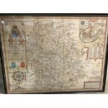
David Loggan, Corpus Christi College [Oxford], 17th century double page engraving, 42 x 53cm;
David Loggan, Corpus Christi College [Oxford], 17th century double page engraving, 42 x 53cm; together with J. W. Edy after Rev. J. Griffith, The ...
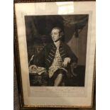
Thomas Watson after Sir Joshua Reynolds, P.R.A., Warren Hastings Esq. Governor General of Bengal,
Thomas Watson after Sir Joshua Reynolds, P.R.A., Warren Hastings Esq. Governor General of Bengal, mezzotint, published London 1777, 36 x 49cm (sh...
Three Havell aquatint views, Cascade on Sneuwberg, plate no. 25, published 1831, 38 x 50cm (sheet); Sion House, 1815, 20.5cm x 30cm (image); View ...
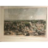
W. Parrott after Edward A. Goodall, Georgetown, British Guiana, lithograph by Hullmandel, c.1844,
W. Parrott after Edward A. Goodall, Georgetown, British Guiana, lithograph by Hullmandel, c.1844, 28.5 x 43cm ...[more]
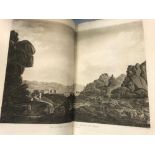
![Giovanni Battista Piranesi, Vedute di Roma, [c.1774 or later], etched title, folding plan, and 52](https://portal-images.azureedge.net/auctions-2018/srche10146/images/7e1a03f7-cc26-4114-a778-942f887e2761.jpg?w=155&h=155)
Giovanni Battista Piranesi, Vedute di Roma, [c.1774 or later], etched title, folding plan, and 52
Giovanni Battista Piranesi, Vedute di Roma, [c.1774 or later], etched title, folding plan, and 52 double page plates, most loose, staining and edg...
Laurent Guyot (French, 1756-1808), Harvest scene, engraving, 9 x 12.5 cm; together with three
Laurent Guyot (French, 1756-1808), Harvest scene, engraving, 9 x 12.5 cm; together with three engraved portraits, Theodor Matham after Joachim van...

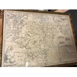
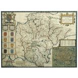
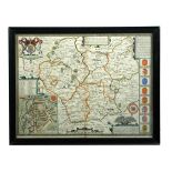
Michael Burghers, The Map of Oxfordshire, hand-coloured engraving for Dr Plot's Natural History of
Michael Burghers, The Map of Oxfordshire, hand-coloured engraving for Dr Plot's Natural History of Oxfordshire, c.1680, 50.5 x 48cms; Richard Blom...
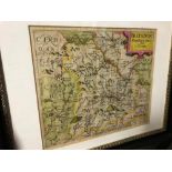
Christopher Saxton and Robert Vaughan, Brecknoc, hand coloured engraved map of Brecknockshire,
Christopher Saxton and Robert Vaughan, Brecknoc, hand coloured engraved map of Brecknockshire, toned, 28 x 32cm, and a map of Norfolk by Morden, 4...
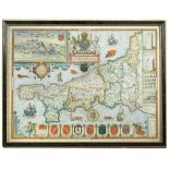
John Speed, Cambridgeshire described with the devision of the hundreds, hand coloured engraved
John Speed, Cambridgeshire described with the devision of the hundreds, hand coloured engraved map, Sudbury and Humble edition c.1611, English te...
John Speed, The Invasions of England and Ireland, coloured double page map, engraved by Cornelius
John Speed, The Invasions of England and Ireland, coloured double page map, engraved by Cornelius Danckerts, for George Humble circa 1627, 39 x 53...
John Speed, Hartfordshire Described, an engraved uncoloured map by Bassett & Chiswell c.1676,
John Speed, Hartfordshire Described, an engraved uncoloured map by Bassett & Chiswell c.1676, English text verso, 40 x 53.5cm; and another Hertfor...
John Speed, Shropshyre Described, hand coloured engraved map for Dixey & Co, 39.5 x 52cm; Anglesey, hand coloured engraved map, Bassett & Chiswell...
John Speed, Huntington both Shire and Shire Towne with the Ancient Citie Ely Described, hand coloured engraved map published Bassett & Chiswell [1...
Joan Blaeu, Cumbria vulgo Cumberland, hand coloured engraved map, French text verso, 43 x 52cm; a
Joan Blaeu, Cumbria vulgo Cumberland, hand coloured engraved map, French text verso, 43 x 52cm; a map of Cumberland by John Speed, published Sudbu...
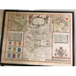
![John Speed, Herefordshire described, hand coloured engraved map, Bassett & Chiswell [1676] , English](https://portal-images.azureedge.net/auctions-2018/srche10146/images/b6588b2d-0e1c-4f45-e247-b212d0c1ee47.jpg?w=155&h=155)
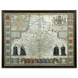
John Speed, Herefordshire described, hand coloured engraved map, Bassett & Chiswell [1676] , English
John Speed, Herefordshire described, hand coloured engraved map, Bassett & Chiswell [1676] , English text verso, 39 x 51cm; The Countye Palatine ...
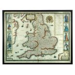
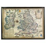
Christopher Saxton and John Speed, The Kingdome of England, engraved by Abraham Goos, hand coloured map dated 1646 [but c.1676] for Bassett and Ch...
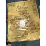
Commercial and Political Map of the British Isles, varnished coloured wall roll map by Geographia,
Commercial and Political Map of the British Isles, varnished coloured wall roll map by Geographia, London, early 20th century, 195 x 151cm ...[...
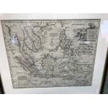
Emanuel Bowen, A New and Accurate Map of the East India Islands, uncoloured engraving, 34 x 42cm
Emanuel Bowen, A New and Accurate Map of the East India Islands, uncoloured engraving, 34 x 42cm ...[more]
Samuel John Neele - Map of Malta, A New Sea and Land Chart of the Sovereign Principality of Malta,
Samuel John Neele - Map of Malta, A New Sea and Land Chart of the Sovereign Principality of Malta, hand coloured engraved dissected map, for Louis...
John Speed, Devonshire with Excester Described, hand coloured engraved map published by Sudbury
John Speed, Devonshire with Excester Described, hand coloured engraved map published by Sudbury and Humble, c.1610, 37 x 50.5cm ...[more]
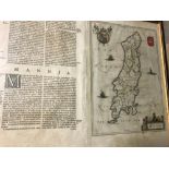
John Speed, Cornwall, 'Described by the travills of John Norden, augmented and published by J.
John Speed, Cornwall, 'Described by the travills of John Norden, augmented and published by J. Speed', hand coloured engraved map published by Sud...
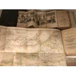
Collection of folding maps. LEIGH (S) Leigh's New Picture of London, 1818, 12mo, 12 folding plates
Collection of folding maps. LEIGH (S) Leigh's New Picture of London, 1818, 12mo, 12 folding plates and map, lacks London plan, damaged binding, ag...
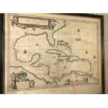
Willem Blaeu, Insulæ Americanæ in Oceano Septentrionali, cum teris adiacentibus. Hand coloured
Willem Blaeu, Insulæ Americanæ in Oceano Septentrionali, cum teris adiacentibus. Hand coloured engraved map showing the West Indies with the East ...
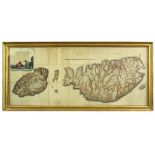
J. and W. Blaeu, Mona, hand coloured engraved map of the Isle of Man, Latin text verso, 48 x 59cm;
J. and W. Blaeu, Mona, hand coloured engraved map of the Isle of Man, Latin text verso, 48 x 59cm; and another smaller map 19 x 26cm (2) ...[mo...
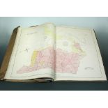
WOODS (James) A New Atlas and Gazetteer of the Isle of Man, consisting of Seventeeen Highly-finished
WOODS (James) A New Atlas and Gazetteer of the Isle of Man, consisting of Seventeeen Highly-finished Maps. London: Day & Son 1867, folio, with 17 ...
John Speed, Leicester, both Countye and Citie described, hand coloured engraved map, Sudbury and
John Speed, Leicester, both Countye and Citie described, hand coloured engraved map, Sudbury and Humble 1610, English text verso, 39 x 51cm ......
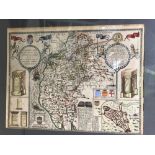
![John Senex, A Plan of the City's [sic] of London, Westminster and Borough of Southwark with the](https://portal-images.azureedge.net/auctions-2018/srche10146/images/2f1e5e1c-47f7-445b-9ee2-074b45a9c3fd.jpg?w=155&h=155)
John Senex, A Plan of the City's [sic] of London, Westminster and Borough of Southwark with the
John Senex, A Plan of the City's [sic] of London, Westminster and Borough of Southwark with the new Additional Buildings. Anno 1720, engraved dou...
R. Wilkinson, Romanum Imperium, coloured engraved map, 19th century, 29 x 44cm; an Ackermann aquatint of Cambridge Prison and Castle, 22 x 29cm, a...
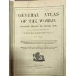
HALL (Sidney) & William HUGHES. General Atlas of the World, A & C Black 1854, new edition, coloured maps including American map with inset New Yor...
![MOLL (Herman) Atlas Minor, London: Thomas Bowles [1732 ?], 238 x 365mm, title damaged and mounted,](https://portal-images.azureedge.net/auctions-2018/srche10146/images/a82c9cce-b730-4007-eed0-278ef593b707.jpg?w=155&h=155)
MOLL (Herman) Atlas Minor, London: Thomas Bowles [1732 ?], 238 x 365mm, title damaged and mounted,
MOLL (Herman) Atlas Minor, London: Thomas Bowles [1732 ?], 238 x 365mm, title damaged and mounted, 62 maps with outline hand colour, including fol...