
Refine your search
Sale Section
Estimate
Category
- Furniture (190)
- Maps (133)
- Coins (70)
- Ceramics (61)
- Collectables (60)
- Books & Periodicals (53)
- Jewellery (37)
- Oil, Acrylic paintings & Mixed Media (34)
- Classic Cars, Motorcycles & Automobilia (25)
- Watercolours (18)
- Chinese Works of Art (16)
- Carpets & Rugs (14)
- Prints (13)
- Metalware (12)
- Sculpture (11)
- Clocks (9)
- Glassware (9)
- Lighting (9)
- Silver & Silver-plated items (9)
- Kitchenalia (8)
- Arms, Armour & Militaria (7)
- Models, Toys, Dolls & Games (7)
- Musical Instruments & Memorabilia (7)
- Salvage & Architectural Antiques (7)
- Watches & Watch accessories (6)
- Japanese Works of Art (5)
- Sporting Memorabilia & Equipment (5)
- Writing Instruments (5)
- Islamic Works of Art (4)
- Textiles (3)
- Vintage Fashion (3)
- Barometers (2)
- Indian Works of Art (2)
- Taxidermy & Natural History (2)
- Bank notes (1)
- Entertainment Memorabilia (1)
- Russian Works of Art (1)
- Scientific Instruments (1)
- Stamps (1)
- Tools (1)
- List
- Grid
A subscription to the Price Guide is required to view results for auctions ten days or older. Click here for more information
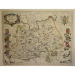

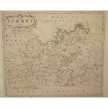
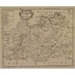
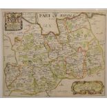
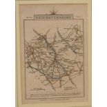
Surrey. A Willem Blaeu coloured map, Surria Vernacule Surrey, mounted, 40 x 51 cm
Surrey. A John Seller tinted map, Surrey Actually Surveyd and Delineated, mounted, 43.5 x 53 cm
Surrey. A John Seller tinted map, Surrey Actually Surveyd and Delineated, mounted, 43.5 x 53 cm
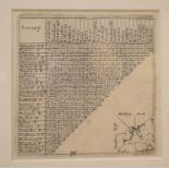
Six G & J Cary folding maps, no 19/21 & 26/28, 1822/23, linen backed, all mounted, each 55.5 x 67 cm
Six G & J Cary folding maps, no 19/21 & 26/28, 1822/23, linen backed, all mounted, each 55.5 x 67 cm (6)Generally good, slightly browned/foxing

Surrey. A Willem Blaeu coloured map, Surria Vernacule Surrey, mounted, 40 x 51 cm Report by RB
Surrey. A Willem Blaeu coloured map, Surria Vernacule Surrey, mounted, 40 x 51 cmReport by RBFolded
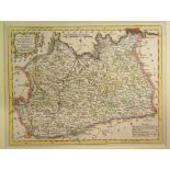
Yorkshire. A John Cary coloured map, A Map of the South part of the West Riding of Yorkshire, From
Yorkshire. A John Cary coloured map, A Map of the South part of the West Riding of Yorkshire, From the best Authorities, mounted, 34 x 53.5 cm, Mo...
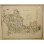
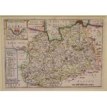
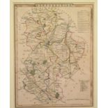
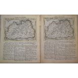
Herefordshire. A John Cary tinted map, A Map of Herefordshire from the Best Authorities, mounted, 54
Herefordshire. A John Cary tinted map, A Map of Herefordshire from the Best Authorities, mounted, 54 x 43.5 cm, a John Cary tinted map, A Map of S...
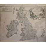
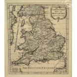
British Isles. A Gilles Robert map, Carte Des Grandes Routes D'Angleterre, D'Ecosseant D'Irlande,
British Isles. A Gilles Robert map, Carte Des Grandes Routes D'Angleterre, D'Ecosseant D'Irlande, mounted, 48.5 x 58.5 cmReport by RBFolded, light...
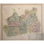
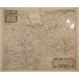
Surrey. A John Cary coloured map, A New Map of Surry, divided into Hundreds Exhibiting It's Roads,
Surrey. A John Cary coloured map, A New Map of Surry, divided into Hundreds Exhibiting It's Roads, Rivers, Parks, mounted, 51 x 57 cm, another, an...
Yorkshire. A Mapp of 20 Miles round Leedes by Order of Mr John Boulter, 31 x 39 cm
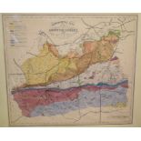
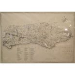
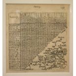
Surrey. A coloured map, Published for the Holmesdale Natural History Club, Ryegate, a Geological map
Surrey. A coloured map, Published for the Holmesdale Natural History Club, Ryegate, a Geological map of the county of Surrey, mounted, 49.5 x 55 c...
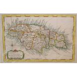
Jamaica. A Jacques Bellin coloured map, Carte De L'Isle De La Jamaique, mounted, 23 x 34 cm, a
Jamaica. A Jacques Bellin coloured map, Carte De L'Isle De La Jamaique, mounted, 23 x 34 cm, a Jacques Bellin tinted map, Carte Des Isles Canaries...

China. A J Wyld coloured map, China, mounted, 24 x 30 cm, another coloured map of China, mounted,
China. A J Wyld coloured map, China, mounted, 24 x 30 cm, another coloured map of China, mounted, 24.5 x 30 cm, a Russian Empire coloured map, mou...
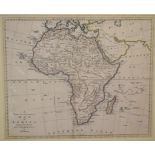
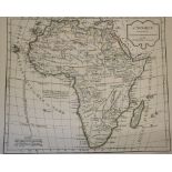
Africa. A Thomas Bowen tinted map, A New and Accurate Map of Africa, Drawn from the best Authorities, mounted, 34.5 x 41.5 cm, a Samuel John Neele...
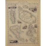
The Mediterranean. A John Tallis tinted map, British Possessions in the Mediterranean, mounted, 36 x
The Mediterranean. A John Tallis tinted map, British Possessions in the Mediterranean, mounted, 36 x 25.5 cm, and two Tallis Hemisphere's - Wester...

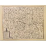
Hungary. A Rigobert Bonne tinted map, Royaume De Hongrie, mounted, 25 x 36 cm, another, Isles De
Hungary. A Rigobert Bonne tinted map, Royaume De Hongrie, mounted, 25 x 36 cm, another, Isles De Corse Et De Sardaigne, mounted, 36 x 24.5 cm, and...
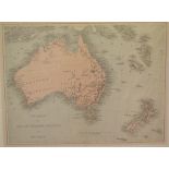
Australia. A coloured map, New Zealand and The Australian Colonies of Great Britain, mounted, 24 x
Australia. A coloured map, New Zealand and The Australian Colonies of Great Britain, mounted, 24 x 31.5 cm, a Blackie map of Australasia & Co, mou...
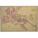
Europe. A coloured map, Europa Antiqua, mounted, 32 x 46 cm, two Bellin Ocean World Cross Winds
Europe. A coloured map, Europa Antiqua, mounted, 32 x 46 cm, two Bellin Ocean World Cross Winds maps, both mounted, 16 x 31 cm, and one other map ...
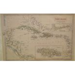
West Indies. A Blackie coloured map, West Indies, mounted, 31.5 x 38 cm, a coloured map, the West
West Indies. A Blackie coloured map, West Indies, mounted, 31.5 x 38 cm, a coloured map, the West Indies from the Best Authorities, mounted, 20.5 ...
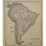
South America. A coloured map, mounted, 38 x 32.5 cm, a coloured map, Central America and the West
South America. A coloured map, mounted, 38 x 32.5 cm, a coloured map, Central America and the West Indies, mounted, 32.5 x 52 cm, a coloured map, ...
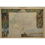
Ocean. A coloured map, Oceanie, with various vignettes, mounted, 33 x 47 cm, and two regional
Ocean. A coloured map, Oceanie, with various vignettes, mounted, 33 x 47 cm, and two regional coloured maps, from the Atlas National Illustre, Dep...
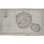
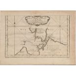
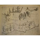
Tahiti. A Jacques Bellin map, Carte De L'Isle De Taiti, Par Le Lieutenant J Cook, 1769, unframed,
Tahiti. A Jacques Bellin map, Carte De L'Isle De Taiti, Par Le Lieutenant J Cook, 1769, unframed, 25.5 x 42 cm See illustrationReport by RBFolded,...
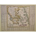
Greece. An Henri Chatelain coloured map, Carte Historique Et Georaphique De L'Ancienne Grece Avec
Greece. An Henri Chatelain coloured map, Carte Historique Et Georaphique De L'Ancienne Grece Avec Des Remarques Curieuses Pour L'Intelligence De ...
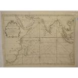
Indian Ocean. A Bellin map, Carte De L'Ocean Oriental Ou Mer Des Indes, mounted, 38.5 x 51 cm, three
Indian Ocean. A Bellin map, Carte De L'Ocean Oriental Ou Mer Des Indes, mounted, 38.5 x 51 cm, three other maps, L'Ocean Occidental, 37 x 51 cm, ...
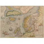
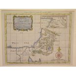
Northern Europe. An Abraham Ortelius coloured map, Septentrionalium Regionum Descrip, Pigmys live in
Northern Europe. An Abraham Ortelius coloured map, Septentrionalium Regionum Descrip, Pigmys live in the Arctic (!), mounted, 36 x 49 cm See ill...
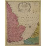
The German Ocean. A coloured map, An Accurate Map of the East Part of England with the Parts of
The German Ocean. A coloured map, An Accurate Map of the East Part of England with the Parts of Holland and Flanders bordering on the German Ocea...
Berkshire. A coloured map, Berkshire, mounted, 35 x 41.5 cm, another coloured map, Essex, mounted,
Berkshire. A coloured map, Berkshire, mounted, 35 x 41.5 cm, another coloured map, Essex, mounted, 36 x 45.5 cm, and another, Buckinghamshire, mo...
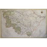
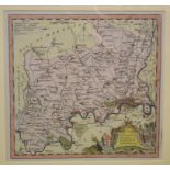
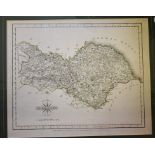
Sussex. A John Cary map, A Map of Sussex from the best Authorities, mounted, 36.5 x 52.5 cm, another
Sussex. A John Cary map, A Map of Sussex from the best Authorities, mounted, 36.5 x 52.5 cm, another coloured map, Middlesex, mounted, 35 x 42 cm...
Surrey. A Robert Morden map, Surrey, mounted, 37 x 43 cm, and a John Cary Map of Surry, From the
Surrey. A Robert Morden map, Surrey, mounted, 37 x 43 cm, and a John Cary Map of Surry, From the best Authorities, mounted, 40.5 x 50 cm (2)
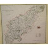
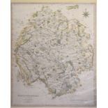
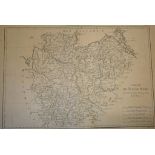
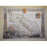
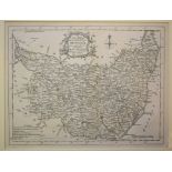
Northamptonshire. A John Cary tinted map, A Map of Northamptonshire from the Best Authorities,
Northamptonshire. A John Cary tinted map, A Map of Northamptonshire from the Best Authorities, mounted, 43 x 48 cm, two John Cary maps, A Map of...
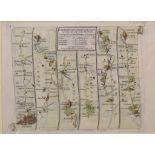
Road Maps. Two coloured title pages, Oxford to Chichester (Cambridge College arms), and Oxford to
Road Maps. Two coloured title pages, Oxford to Chichester (Cambridge College arms), and Oxford to Cambridge (Oxford College arms), both mounted, ...
Road Map. A tinted map, A Map of the Road from London to Berwick, commencing at York, mounted, 18.
Road Map. A tinted map, A Map of the Road from London to Berwick, commencing at York, mounted, 18.5 x 29 cm, another, London to Portsmouth, Chich...
Surrey. A Robert Morden map, Surrey, mounted, 18 x 21.5 cm, and a Richard Blome coloured map,
Surrey. A Robert Morden map, Surrey, mounted, 18 x 21.5 cm, and a Richard Blome coloured map, Surrey, mounted, 15.5 x 22 cm (2)Report by RBBlome m...
Surrey. A Robert Morden coloured map, mounted, 18 x 21.5 cm, and a Richard Blome tinted map, Surrey,
Surrey. A Robert Morden coloured map, mounted, 18 x 21.5 cm, and a Richard Blome tinted map, Surrey, mounted, 15.5 x 22 cm (2)Report by RBBoth fol...
Surrey. A Richard Blome map, A Mapp of Surrey, with it's Hundreds, mounted, 27 x 32.5 cm
Britain, a Sanson map, La Britannique dans sa Heptarchie, Anglois-Saxonique, mounted, 24.5 x 21
Britain, a Sanson map, La Britannique dans sa Heptarchie, Anglois-Saxonique, mounted, 24.5 x 21 cm, and a map of Surrey, mounted, 10 x 13 cm
Surrey. A Richard Blome coloured map, A Mapp of Surrey, with it's Hundreds, mounted, 26.5 x 32 cm
Surrey. A Richard Blome coloured map, A Mapp of Surrey, with it's Hundreds, mounted, 26.5 x 32 cm
Assorted county and other maps, including Bedfordshire, Oxfordshire, Huntingdonshire, Middlesex,
Assorted county and other maps, including Bedfordshire, Oxfordshire, Huntingdonshire, Middlesex, Westmoreland, and others, all mounted (16)
Eight coloured road maps, including Roads to Arundel, Bognor (By Petworth), Chichester, Portsmouth, The Road from London to York, and Kingston to ...
The Four Continents, a set of four Robert De Vaugondy tinted maps, L'Afrique, L'Asie, L'Amerique and
The Four Continents, a set of four Robert De Vaugondy tinted maps, L'Afrique, L'Asie, L'Amerique and L'Europe, all unframed, with pencil notes, 31...
Eighteen John Cary county maps, all mounted, each approx. 15.5 x 10 cm (18)
Surrey. A Van Langeren map of Surrey, with distances, mounted, 12 x 11 cm, a coloured map of Hamp-
Surrey. A Van Langeren map of Surrey, with distances, mounted, 12 x 11 cm, a coloured map of Hamp-Shire, mounted, 17 x 20 cm, a Thomas Kitchin map...
A large group of French maps, including Bellin, Bonne, Laurent, and others, all unframed (box)
A large group of French maps, including Bellin, Bonne, Laurent, and others, all unframed (box)Report by RB35 in total
Middlesex. A Thomas Kitchin coloured map, Middlesex, Drawn from an Accurate Survey, mounted, 19.5
Middlesex. A Thomas Kitchin coloured map, Middlesex, Drawn from an Accurate Survey, mounted, 19.5 x 20.5 cm, a coloured map, The Isles of Zetland,...
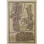
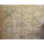
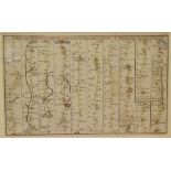
Four Ward Plans, including Aldersgate/Bishopsgate/Bread Street & Cordwainers, all mounted, 34 x 22
Four Ward Plans, including Aldersgate/Bishopsgate/Bread Street & Cordwainers, all mounted, 34 x 22 cm, two others, coloured, and a Plan Du Fort et...
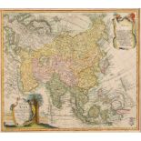
Asia. A Leonhard Euler coloured map, Tab Geogr Asiae, 34 x 38.5 cm See illustration Report by RB
Asia. A Leonhard Euler coloured map, Tab Geogr Asiae, 34 x 38.5 cm See illustrationReport by RBFolded, no glass to frameReport by GHThe exact date...
A large group of French maps, probably from Prevost's L'Histori Generale Des Voyages 1747-61, all
A large group of French maps, probably from Prevost's L'Histori Generale Des Voyages 1747-61, all unframed, some with pencil notes (box) See illus...
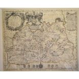
Assorted world coloured maps, including Persia, Turkey in Asia, Sardinia, Hungary, Egypt and others,
Assorted world coloured maps, including Persia, Turkey in Asia, Sardinia, Hungary, Egypt and others, all mounted (18)
Surrey. A Thomas Kitchin coloured map, Surrey, mounted, 18 x 21 cm, a Van Langeren map of Surrey,
Surrey. A Thomas Kitchin coloured map, Surrey, mounted, 18 x 21 cm, a Van Langeren map of Surrey, with distances, mounted, 10.5 x 10.5 cm, and fou...

Fifteen small Wallis county maps, mostly coloured, and eleven small town/country maps, all mounted (26)
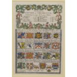
Surrey, Sussex and London. A Michael Drayton/William Hole allegorical map, of the area around
Surrey, Sussex and London. A Michael Drayton/William Hole allegorical map, of the area around London, a first edition of 1612 which is without pl...

An album of small maps, 17th century onwards, some coloured, several with annotations, including
An album of small maps, 17th century onwards, some coloured, several with annotations, including Surrey
Assorted coloured maps, including The Isle of Man, Kent, Environs of London and others, all mounted (9)
Yorkshire. A John Cary tinted map, North Riding of Yorkshire, mounted, 23 x 28.5 cm, a Moll coloured
Yorkshire. A John Cary tinted map, North Riding of Yorkshire, mounted, 23 x 28.5 cm, a Moll coloured map of Surrey, mounted, 20 x 32 cm, and two o...
Surrey. A Thomas Kitchin map, A New Map of The County of Surrey, mounted, 20.5 x 26.5 cm, a Moll
Surrey. A Thomas Kitchin map, A New Map of The County of Surrey, mounted, 20.5 x 26.5 cm, a Moll coloured map of Surrey, mounted, 19.5 x 31.5 cm, ...
An Album of maps, mostly surrey, including Cary, Pigot, Cowley, Kitchin, Ellis, and Gibson, some
An Album of maps, mostly surrey, including Cary, Pigot, Cowley, Kitchin, Ellis, and Gibson, some coloured, many with pencil annotations
Suffolk. A Thomas Kitchin map, A New Map of the County of Suffolk, mounted, 20.5 x 26.5 cm, a John
Suffolk. A Thomas Kitchin map, A New Map of the County of Suffolk, mounted, 20.5 x 26.5 cm, a John Cary tinted map of Yorkshire, mounted, a Moll c...

Eight Fullarton county maps, and six Lewis' Topographical Dictionary maps, all mounted (14)

Surrey. A John Speed facsimile reproduction, Surrey Described and Divided into Hundreds, mounted,
Surrey. A John Speed facsimile reproduction, Surrey Described and Divided into Hundreds, mounted, six Simkin regimental prints, and other assorted...