
Filtered by:
- Category
- List
- Grid
A subscription to the Price Guide is required to view results for auctions ten days or older. Click here for more information

Early maps: Europe, by Braun, Coronelli, De Wit, Jansson, Ortelius, Sanson, and von Pufendorf
Early maps: Europe, by Braun, Coronelli, De Wit, Jansson, Ortelius, Sanson, and von Pufendorf 1580, DIE STAT SWYBVSCHIN IN NIDER SCHLESIEN, sheet ...
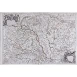
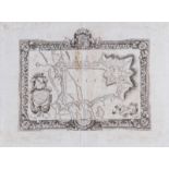
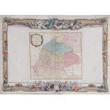
Early map: Hungary, by Giacomo Giovanni Rossi Rome, 1686, L'UNGARIA NUOVAMENTE DESCRITTA ET
Early map: Hungary, by Giacomo Giovanni Rossi Rome, 1686, L'UNGARIA NUOVAMENTE DESCRITTA ET ACCRESIUTA DA VARIE NOTIZIE DA GIACOMO CANTELLI DA VIG...
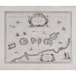
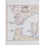
Rare maps: Spice Islands, Calecut, Santo Paulo, Madagascar and others Amsterdam, circa 1640, Jan
Rare maps: Spice Islands, Calecut, Santo Paulo, Madagascar and others Amsterdam, circa 1640, Jan Jansson, INSULARUM MOLUCCARUM NOVA DESCRIPTIO, sh...
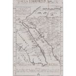
Early map: California, Fra. Eusebio Kino published: Augsburg 1726, TABULA CALIFORNIAE ANNO 1702 EX
Early map: California, Fra. Eusebio Kino published: Augsburg 1726, TABULA CALIFORNIAE ANNO 1702 EX AUTOPTICA OBSERVATIONE DELINEATA A R.P. CHINO E...
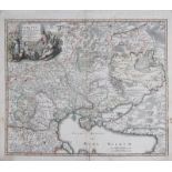
Early map: Ukraine and the Black Sea, Johann Baptiste Homann published Nuremberg, circa 1720,
Early map: Ukraine and the Black Sea, Johann Baptiste Homann published Nuremberg, circa 1720, UKRANIA QUAE ET TERRA COSACCORUM CUM VICINIS WALACHI...
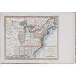
Scarce early map: Southern United States, Louis Brion de la Tour Paris, circa 1779-94, CARTE DES
Scarce early map: Southern United States, Louis Brion de la Tour Paris, circa 1779-94, CARTE DES ETATS-UNIS D'AMERIQUE ET DU COURS DU MISSISSIPI, ...
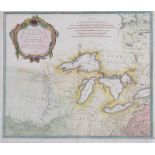
Scarce map: Canada and Louisiana, Jean Baptiste Anville Published Paolo Santini, Venice 1775, PARTIE
Scarce map: Canada and Louisiana, Jean Baptiste Anville Published Paolo Santini, Venice 1775, PARTIE OCCIDENTALE DU CANADA ET SEPTENTRIONALE DE LA...
Early map: Caspian Sea, De Rossi and Ottens Published : Rome, Domenico de Rossi, 1723, NOVISSIMA, ET
Early map: Caspian Sea, De Rossi and Ottens Published : Rome, Domenico de Rossi, 1723, NOVISSIMA, ET ACCURATA MARIS CASPIJ FERE NOBIS INCOGNITI RE...

Early maps: Italian, by Appellee, Coronelli, Cluver, Dubosc and Ortelius c. 1750, COFU, sheet H11"
Early maps: Italian, by Appellee, Coronelli, Cluver, Dubosc and Ortelius c. 1750, COFU, sheet H11" W6 1/2" c. 1570, ELBA, sheet H4 1/2" W6" c...
Rare map: Strait of Gibraltar by Santini and Remondini published: Venice, 1780, NOUVELLE CARTE DU
Rare map: Strait of Gibraltar by Santini and Remondini published: Venice, 1780, NOUVELLE CARTE DU DETROIT DE GIBRALTAR ET DE L'ISLE DE CADIX, hand...
Early European maps: including Cluever, Merian, de Rossi, and Zatta 1659, SCALDIA MOSAE, H11 3/4"
Early European maps: including Cluever, Merian, de Rossi, and Zatta 1659, SCALDIA MOSAE, H11 3/4" W16" 1693, WEG VON PIGNEROL NACH TURINMARSAILL...
Early maps: Greece, by Coronelli and Ortelius c. 1570, CYPRUS INSULA, sheet H8 1/4" W18 1/2" c.
Early maps: Greece, by Coronelli and Ortelius c. 1570, CYPRUS INSULA, sheet H8 1/4" W18 1/2" c. 1686, PIANTA DELLA FORTEZZA, E CITTA DI MODONE, ...
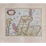
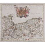
Early maps: Ireland and Scotland, Gerard Mercator and Henricus Hondius published Amsterdam, circa
Early maps: Ireland and Scotland, Gerard Mercator and Henricus Hondius published Amsterdam, circa 1630-1670 NORTHUMBRIA, CUMBERLANDIA ET DUNELME...
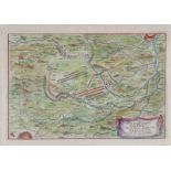
Early map: Cambrai fortification, by Vincenzo Maria Coronelli Venice, dated 1698, CAMBRAY DEDICATO..., uncolored, sheet H19" W25 1/2" ...[more]
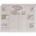
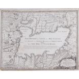
Early map: Eastern United States, Jamaica and Islands, Henri Chatelain published: Amsterdam, 1719,
Early map: Eastern United States, Jamaica and Islands, Henri Chatelain published: Amsterdam, 1719, CARTE QUI CONTIENT UNE DESCRIPTION DES ILES & T...
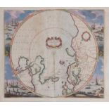
Map: Poli Arctici, Henricus Hondius Amsterdam, circa 1636, POLI ARCTICI, ET CIRCUMIACENTIUM TERRARUM
Map: Poli Arctici, Henricus Hondius Amsterdam, circa 1636, POLI ARCTICI, ET CIRCUMIACENTIUM TERRARUM DESCRIPTIO NOVISSIMA, hand-colored first stat...
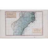
Early map: Southern United States, Rigobert Bonne published: Paris, 1787. CARTE DE LA PARTIE SUD,
Early map: Southern United States, Rigobert Bonne published: Paris, 1787. CARTE DE LA PARTIE SUD, DES ETATS UNIS DE L' AMERIQUE SEPTENTRIONALE, ha...
Early maps: Hungary, by Brion and Janvier 1766, LA HONGRIE AVEC LES PROVINCES, sheet H15 1/4" W21
Early maps: Hungary, by Brion and Janvier 1766, LA HONGRIE AVEC LES PROVINCES, sheet H15 1/4" W21 1/8" 1780, LE ROYAUME DE HONGRIE, sheet H15" W...