
Filtered by:
- Category
- List
- Grid
This auctioneer has chosen to not publish their results. Please contact them directly for any enquiries.
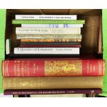

LOCAL HISTORY TOPOGRAPHY. Ramsay Muir - Bygone Liverpool, pub Henry Young and Son, 1913. George
LOCAL HISTORY TOPOGRAPHY. Ramsay Muir - Bygone Liverpool, pub Henry Young and Son, 1913. George Davis/Alfred Davis - The River Irwell and its Trib...
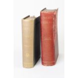
W T Fernie - Herbal Simples Approved for Modern Uses of Cure, third edition, pub John Wright &
W T Fernie - Herbal Simples Approved for Modern Uses of Cure, third edition, pub John Wright & Sons 1914. Together with W T Fernie - Meals Medicin...
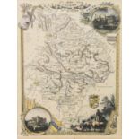
ANTIQUE HAND COLOURED MAP OF HUNTINGDONSHIRE BY T. MOULE 11” X 7 ½” (28cm x 19cm) AND TWO LATER MAPS
ANTIQUE HAND COLOURED MAP OF HUNTINGDONSHIRE BY T. MOULE 11” X 7 ½” (28cm x 19cm) AND TWO LATER MAPS OF NORTHUMBERLAND and DURHAM, of similar size...
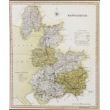
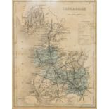
TWO NINETEENTH CENTURY HAND COLOURED MAPS PUBLISHED BY HENRY TEESDALE Cheshire 13 ¼” x 16” (33.7cm x
TWO NINETEENTH CENTURY HAND COLOURED MAPS PUBLISHED BY HENRY TEESDALE Cheshire 13 ¼” x 16” (33.7cm x 40.7cm) Lancashire 16” x 13 ¼” (40.7cm x 3...
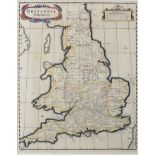
ANTIQUE HAND COLOURED MAP OF GREAT BRITAIN (BRITANNIA SAXONICA) BY ROBERT MORDEN, FROM CAMDEN’S
ANTIQUE HAND COLOURED MAP OF GREAT BRITAIN (BRITANNIA SAXONICA) BY ROBERT MORDEN, FROM CAMDEN’S BRITANNIA, 14 ½” X 11 ½” (36.8cm x 29.2cm), framed...
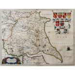
ANTIQUE HAD COLOURED MAP OF ‘THE EAST RIDING OF YORKSHIRE’ BY J BLAEU’S FROM THEATRUM ORBIS TERRARUM
ANTIQUE HAD COLOURED MAP OF ‘THE EAST RIDING OF YORKSHIRE’ BY J BLAEU’S FROM THEATRUM ORBIS TERRARUM SIVE ATLAS NOVUS, with eight heraldic shields...
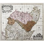
ANTIQUE HAND COLOURED MAP OF NORTHERN SCOTLAND (ROSSIA, SUTHERLANDIA, CATHENESIA ET STRATH-NAVERNIE’
ANTIQUE HAND COLOURED MAP OF NORTHERN SCOTLAND (ROSSIA, SUTHERLANDIA, CATHENESIA ET STRATH-NAVERNIE’ BY P SCHENK & G VALK, 17 ¼” x 20 ¼” (43.8cm x...
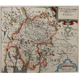
ANTIQUE HAND COLOURED MAP OF WESTMORLAND BY CHRISTOPHER SAXTON, 10 ½” X 12 ¼” (26.7cm x 31.1cm),
ANTIQUE HAND COLOURED MAP OF WESTMORLAND BY CHRISTOPHER SAXTON, 10 ½” X 12 ¼” (26.7cm x 31.1cm), framed and glazed C/R- tight margins, strong ver...
AFTER G ZULIANI BY G PITTERI ANTIQUE HAND COLOURED MAP OF THE NORTHERN PART OF ENGLAND AND WALES 12”
AFTER G ZULIANI BY G PITTERI ANTIQUE HAND COLOURED MAP OF THE NORTHERN PART OF ENGLAND AND WALES 12” X 15 ¾” (30.5cm x 40cm) AND A LATER BOOKPLA...