
Filtered by:
- Show only bulk lots,
- Category
- List
- Grid
A subscription to the Price Guide is required to view results for auctions ten days or older. Click here for more information

J. AIKIN. A Description of the Country from thirty to forty miles round Manchester. Printed for John
J. AIKIN. A Description of the Country from thirty to forty miles round Manchester. Printed for John Stockdale, London June 4th 1795, illustrated ...
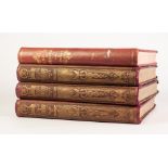
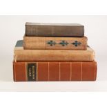
BAINES. Lancashire and Cheshire Past and Present. Published Mackenzie, c.1880, 4 volume set, 3
BAINES. Lancashire and Cheshire Past and Present. Published Mackenzie, c.1880, 4 volume set, 3 original binding being re-cased, one volume rebou...

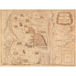
TOPOGRAPHY/LOCAL INTEREST - BRITISH MEDICAL ASSOCIATION 70th Annual Meeting 1902 Manchester. Published by F. Ireland - John Harland. The History...
ABOUT BRITAIN SERIES. No. 7 North Wales, No. 9 Lancashire and Yorkshire, No. 8 East Midlands. a
ABOUT BRITAIN SERIES. No. 7 North Wales, No. 9 Lancashire and Yorkshire, No. 8 East Midlands. a 1950'S Sonny Weymouth Guide, Hugh Murray. A Gramma...
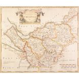
ANTIQUE HAND COLOURED MAP OF THE COUNTY PALATINE OF CHESTER BY ROBERT MORDEN, 14" x 16 ¾" (35.6cm
ANTIQUE HAND COLOURED MAP OF THE COUNTY PALATINE OF CHESTER BY ROBERT MORDEN, 14" x 16 ¾" (35.6cm x 42.6cm), tightly mounted, unframed
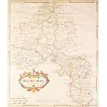
ANTIQUE HAND COLOURED MAP OF THE COUNTY PALATINE OF OXFORDSHIRE BY ROBERT MORDEN, 17" x 14 ½" (43.
ANTIQUE HAND COLOURED MAP OF THE COUNTY PALATINE OF OXFORDSHIRE BY ROBERT MORDEN, 17" x 14 ½" (43.2cm x 36.8cm)
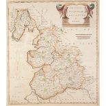
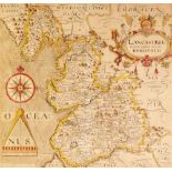
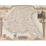
ANTIQUE HAND COLOURED MAP OF THE COUNTY PALATINE OF LANCASTER BY ROBERT MORDEN, 17" x 14 ½" (43.
ANTIQUE HAND COLOURED MAP OF THE COUNTY PALATINE OF LANCASTER BY ROBERT MORDEN, 17" x 14 ½" (43.2cm x 36.8cm), tightly mounted
ANTIQUE HAND COLOURED MAP OF MIDDLESEX BY ROBERT MORDEN, 14 ½" x 17" (36.8cm x 43.2cm), tightly
ANTIQUE HAND COLOURED MAP OF MIDDLESEX BY ROBERT MORDEN, 14 ½" x 17" (36.8cm x 43.2cm), tightly mounted
ANTIQUE MAP OF JUDA AND ISRAEL BY HERBERT JAILLOT,with outlined colouring showing the twelve
ANTIQUE MAP OF JUDA AND ISRAEL BY HERBERT JAILLOT,with outlined colouring showing the twelve tribes of Israel, the impression, 22" x 33 ¼" (55.9cm...
ANTIQUE HAND COLOURED MAP OF THE ANCIENT CITY OF JERUSALEM BY H. GAVIN, EDINBURGH, 6 ½" x 9" (16.5cm
ANTIQUE HAND COLOURED MAP OF THE ANCIENT CITY OF JERUSALEM BY H. GAVIN, EDINBURGH, 6 ½" x 9" (16.5cm x 22.9cm)
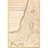
ANTIQUE MAP OF PALESTINE BY W.H. JONES, with outlined colouring, 11 ¾" x 8" (29.8cm x 20.3cm), AND
ANTIQUE MAP OF PALESTINE BY W.H. JONES, with outlined colouring, 11 ¾" x 8" (29.8cm x 20.3cm), AND ANOTHER, split into four, published by Justus P...
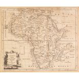
ANTIQUE MAP OF AFRICA BY THOMAS HITCHIN, 7 ¼" X 8 ¾" (18.4cm x 22.2cm), TWO MAPS OF SOUTH AFRICA
ANTIQUE MAP OF AFRICA BY THOMAS HITCHIN, 7 ¼" X 8 ¾" (18.4cm x 22.2cm), TWO MAPS OF SOUTH AFRICA PUBLISHED BY JOHN BARTHOLOMEW FOR THE CITIZEN'S A...
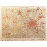
TWO ORDANANCE SURVEY 'LAND UTILISATION SURVEY OF BRITAIN' COLOUR MAPS, 'Liverpool & Birken head (
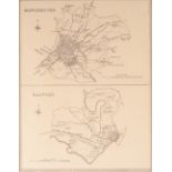
TWO ORDANANCE SURVEY 'LAND UTILISATION SURVEY OF BRITAIN' COLOUR MAPS, 'Liverpool & Birken head (sheet 35) and Bolton & Manchester (sheet 36), 19"...
ANTIQUE MAP OF MONTGOMERYSHIRE BY JOHN SPEED, with town plan upper left, and text verso, 15" x
ANTIQUE MAP OF MONTGOMERYSHIRE BY JOHN SPEED, with town plan upper left, and text verso, 15" x 20", (38cm x 50.8cm), foxing, ...[more]
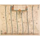
ANTIQUE HAND COLOURED ROAD MAP, 'YORK TO WEST CHESTER' BY JOHN OGILBY, 13 ¼" x 17 ¼" (33.7cm x 43.
ANTIQUE HAND COLOURED ROAD MAP, 'YORK TO WEST CHESTER' BY JOHN OGILBY, 13 ¼" x 17 ¼" (33.7cm x 43.8cm)
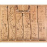
ANTIQUE HAND COLOURED ROAD MAP, 'St. DAVIDS TO HOLYWELL' BY JOHN OGILBY, 13 ½" x 17 ½" (34.3cm x
ANTIQUE HAND COLOURED ROAD MAP, 'St. DAVIDS TO HOLYWELL' BY JOHN OGILBY, 13 ½" x 17 ½" (34.3cm x 44.4cm) heavily faded
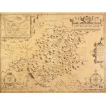
ANTIQUE HAND COLOURED MAP OF LANCASTER BY CHRISTOPHER SAXTON, 11 ½" x 12" (29.2cm x 30.5cm)
ANTIQUE HAND COLOURED MAP OF DEVONSHIRE BY EMAN BOWEN, with Hundreds index lower right, 6 ¾" x
ANTIQUE HAND COLOURED MAP OF DEVONSHIRE BY EMAN BOWEN, with Hundreds index lower right, 6 ¾" x 7 ½" (17.2cm x 19cm) and a Bookplate map of Caernar...
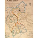
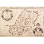
ANTIQUE HAND COLOURED MAP OF LANCASTER BY ROBERT MORDEN, 17" X 15" (43.2cm x 38.1cm) unframed but
ANTIQUE HAND COLOURED MAP OF LANCASTER BY ROBERT MORDEN, 17" X 15" (43.2cm x 38.1cm) unframed but stuck down, LATER MAP OF THE DIOCESE OF CARLISLE...
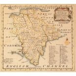
ANTIQUE HAND COLOURED MAP OF MONMOUTHSHIRE BY JOHN CARY, 10 ¼" x 8 ¼" (26cm x 21cm) AND EIGHT
ANTIQUE HAND COLOURED MAP OF MONMOUTHSHIRE BY JOHN CARY, 10 ¼" x 8 ¼" (26cm x 21cm) AND EIGHT LATER MAPS, including FIVE BY THOMAS MOULE, 'Lanc...
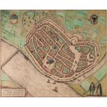
ANTIQUE HAND COLOURED MAP OF DEVENTER, (NETHERLANDS) BY BRAUN-HOGENBERG, 13" x 15 ¾" (33cm x 40cm)
ANTIQUE HAND COLOURED MAP OF DEVENTER, (NETHERLANDS) BY BRAUN-HOGENBERG, 13" x 15 ¾" (33cm x 40cm) framed and glazed and no text verso ...[more]
'PLAN OF THE MANCHESTER SHIP CANAL' A FACSIMILE PRINT IN GLAZED FRAME, ALSO J. RAPKIN HAND COLOURED ENGRAVED MAP OF 'WESTERN AUSTRALIAN SWAN RIV...