
Refine your search
Filtered by:
- Category
- List
- Grid
A subscription to the Price Guide is required to view results for auctions ten days or older. Click here for more information

A SELECTION OF VARIOUS MAPS OF LONDON, MANCHESTER to include; an early Ordnance Survey folded map
A SELECTION OF VARIOUS MAPS OF LONDON, MANCHESTER to include; an early Ordnance Survey folded map areas of Manchester circa 1850's, BACON'S NEW MA...
HUGHES, WILLIAM - 'The Modern Atlas of The Earth'. No date 4to, Original cloth with ANOTHER (2)
HUGHES, WILLIAM - 'The Modern Atlas of The Earth'. No date 4to, Original cloth with ANOTHER (2)
BARTHOLOMEW, J.G. 'The Citizens Atlas', circa 1898, maroon cloth and gilt. Published by George
BARTHOLOMEW, J.G. 'The Citizens Atlas', circa 1898, maroon cloth and gilt. Published by George Newnes and THE READERS DIGEST, GREAT WORLD ATLAS
JOHNSTON, ALEX KEITH 'HANDY ROAYL ATLAS OF MODERN GEOGRAPHY' published by W & AK Johnston, Edinburgh
JOHNSTON, ALEX KEITH 'HANDY ROAYL ATLAS OF MODERN GEOGRAPHY' published by W & AK Johnston, Edinburgh and London MDCCCLXXVI (1876), new edition wit...
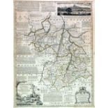
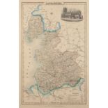
LANCASHIRE COUNTY COUNCIL' 'A PRELIMINARY PLAN FOR LANCASHIRE', JULY 1951, WITH BOX SECTION WITH
LANCASHIRE COUNTY COUNCIL' 'A PRELIMINARY PLAN FOR LANCASHIRE', JULY 1951, WITH BOX SECTION WITH MAPS
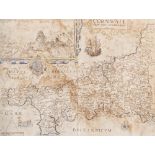
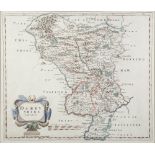
WILLIAM KIP ANTIQUE HAND COLOURED MAP OF CORNWALL 11 1/2" x 15 1/4" (29.2cm x 38.8cm) (a.f.) AND A
WILLIAM KIP ANTIQUE HAND COLOURED MAP OF CORNWALL 11 1/2" x 15 1/4" (29.2cm x 38.8cm) (a.f.) AND A REPRODUCTION MAP OF EUROPE (2) ...[more]
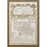
EMANUEL BOWEN (1694 - 1767), COPPER PLATE ENGRAVED COUNTY MAP OF CAMBRIDGESHIRE with old hand
EMANUEL BOWEN (1694 - 1767), COPPER PLATE ENGRAVED COUNTY MAP OF CAMBRIDGESHIRE with old hand colouring, 27 1/2" x 20 1/2" (70 x 52cm) borderl...
EMANUEL BOWEN (1694 - 1767) COPPER PLATE ENGRAVED COUNTY MAP OF HUNTINGDON with old hand colouring, 27 1/2" x 20 1/2" (70 x 52cm) borderline ...
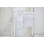
SELECTION OF CIRCA 1960s ADMIRALTY PUBLISHED NAVIGATION CHARTS IN NATURAL SCALE 1:37,500 AND OTHER
SELECTION OF CIRCA 1960s ADMIRALTY PUBLISHED NAVIGATION CHARTS IN NATURAL SCALE 1:37,500 AND OTHER SCALES to include Belfast Lough, with larger sc...
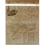
TWO ANTIQUE HAND COLOURED MAPS BY ROBERT MORDEN, 'Lancaster', 16" x 14" (40.7 x 35.6cm), 'Derbyshire', 14" x 16" (35.6 x 40.7cm) (2)
THREE 19th CENTURY HAND COLOURED MAPS comprising 'An Ancient of St James's, Westminster Abbey and
THREE 19th CENTURY HAND COLOURED MAPS comprising 'An Ancient of St James's, Westminster Abbey and Hall etc. from the Village of Charing, now Chari...
MID 19th CENTURY 'ATLAS OF ANCIENT GEOGRAPHY' by Samuel Butler, Lord Bishop of Lichfield & Coventry,
MID 19th CENTURY 'ATLAS OF ANCIENT GEOGRAPHY' by Samuel Butler, Lord Bishop of Lichfield & Coventry, with twenty one two-page maps and four smalle...
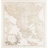
ANTIQUE FRENCH HAND COLOURED MAP OF THE OTTOMAN EMPIRE BY G. ROBERT DE VAUGONDY, 18 3/4" x 17 1/
ANTIQUE FRENCH HAND COLOURED MAP OF THE OTTOMAN EMPIRE BY G. ROBERT DE VAUGONDY, 18 3/4" x 17 1/2" (47.6 X 44.4cm)