
Filtered by:
- Category
- List
- Grid
A subscription to the Price Guide is required to view results for auctions ten days or older. Click here for more information
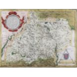

Georg Braun (1541-1622) and Frans Hogenberg (circa 1535-1588) - Coloured engraving - Map of "
Georg Braun (1541-1622) and Frans Hogenberg (circa 1535-1588) - Coloured engraving - Map of "Moraviae", with shaped cartouche to upper left, and s...
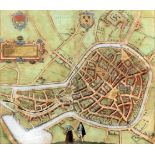
Georg Braun (1541-1622) and Frans Hogenberg (circa 1535-1588) - Coloured engraving - "Berga", -
Georg Braun (1541-1622) and Frans Hogenberg (circa 1535-1588) - Coloured engraving - "Berga", - Birdseye view of the City of Bergam, with descript...
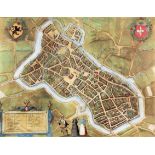
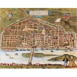
Georg Braun (1541-1622) and Frans Hogenberg (circa 1535-1588) - Coloured engraving - "Lille", -
Georg Braun (1541-1622) and Frans Hogenberg (circa 1535-1588) - Coloured engraving - "Lille", - Birdseye view of the City of Lille, with descripti...
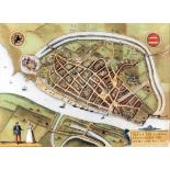
Georg Braun (1541-1622) and Frans Hogenberg (circa 1535-1588) - Coloured engraving - "Slvys", -
Georg Braun (1541-1622) and Frans Hogenberg (circa 1535-1588) - Coloured engraving - "Slvys", - Birdseye view of the Town of Sluis, with descripti...
Georg Braun (1541-1622) and Frans Hogenberg (circa 1535-1588) - Coloured engraving - "Aurelia
Georg Braun (1541-1622) and Frans Hogenberg (circa 1535-1588) - Coloured engraving - "Aurelia Franciae Civitas", - Birdseye view of the City of Av...
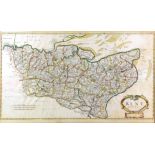
Robert Morden (1668-1703) - Coloured engraving - Map of "Kent", 13.75ins x 24.75ins, William Kip (
Robert Morden (1668-1703) - Coloured engraving - Map of "Kent", 13.75ins x 24.75ins, William Kip (active 1598-1610) after John Norden - Coloured e...
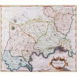
Robert Morden (1668-1703) - Coloured engraving - Map of "Middlesex", published by Abel Swale and
Robert Morden (1668-1703) - Coloured engraving - Map of "Middlesex", published by Abel Swale and John Churchill, 16.75ins x 14.25ins, and two colo...