Filtered by:
- Category
- List
- Grid
A subscription to the Price Guide is required to view results for auctions ten days or older. Click here for more information
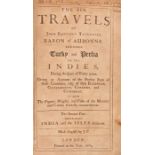

John Baptistat Tavernier, The six voyages of John Baptista Tavernier, Baron of Aubonne through
John Baptistat Tavernier, The six voyages of John Baptista Tavernier, Baron of Aubonne through Turky, into Persia and the East-Indies, for the spa...
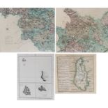
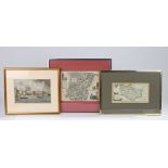
Maps, to include A Map of Northampton, W.H. Toms, Pacific, Plans in Society & Cook Islands, Cook &
Maps, to include A Map of Northampton, W.H. Toms, Pacific, Plans in Society & Cook Islands, Cook & King and two maps by C Smith of the North of En...
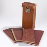
Sifton Praed & Co 1929 maps, the four folding maps for North Central, South Central, South and north
Sifton Praed & Co 1929 maps, the four folding maps for North Central, South Central, South and north England and Wales, all housed within the orig...
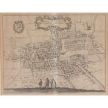
Map depicting the Hague circa 1560, titled and dated top centre and flanked by two crests, with
Map depicting the Hague circa 1560, titled and dated top centre and flanked by two crests, with figures meeting on a hillside to the lower centre
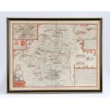
John Speede map of Hertfordshire, Hartford Shire Described The situations of Hartford and the most
John Speede map of Hertfordshire, Hartford Shire Described The situations of Hartford and the most ancient Towne S Albons with such memorable acti...
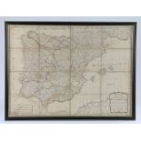
19th Century folding map of Spain and Portugal, published by Laurie & Whittle, with hand written
19th Century folding map of Spain and Portugal, published by Laurie & Whittle, with hand written details verso, housed in a double sided glazed eb...
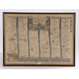
John Ogilby, strip map depicting the road from London to Holy Head, 45cm x 43cm
Maps, to include Weedman & Mutlore 1798 Map of the Country from 14 to 18 miles around Windsor,
Maps, to include Weedman & Mutlore 1798 Map of the Country from 14 to 18 miles around Windsor, together with 1750 Middlesex, Essex 1844 and The Ci...
18th Century map "Broad Street & Cornhill Wards divided into parishes according to a new survey",
18th Century map "Broad Street & Cornhill Wards divided into parishes according to a new survey", 23.5cm x 18cm, housed in a silvered glazed frame...
John Ogilby (1600-1676) The Road from London to Yarmouth, together with a Walker map of Suffolk, (
John Ogilby (1600-1676) The Road from London to Yarmouth, together with a Walker map of Suffolk, (2)
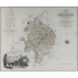
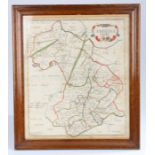
Greenwood & Co, Map of Warwick, engraved by J & C Walker, 1830m image of Warwick castle bottom
Greenwood & Co, Map of Warwick, engraved by J & C Walker, 1830m image of Warwick castle bottom corner, 69cm x 57cm ...[more]
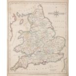
John Cary, General map of South Britain and Wales, binding missing
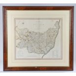
New map of the County of Suffolk, divided into hundreds, published London and printed for C.
New map of the County of Suffolk, divided into hundreds, published London and printed for C. Smith, No.172 Strand, January 6th 1804, 49 x 44cm
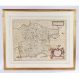
Christopher Saxton, Suffolk,16th century map, 'Suffolciae Comitatus Continens in Oppida Mercatoria
Christopher Saxton, Suffolk,16th century map, 'Suffolciae Comitatus Continens in Oppida Mercatoria 25 Pagos et Villas 464 una cum Singulis Hundred...
Collection of early 20th Century Dutch maps, with various maps of the World, also together with
Collection of early 20th Century Dutch maps, with various maps of the World, also together with scientific and engineering plans, (qty)
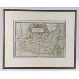
Map of Essex, Amstelodami, Sumptibus Loannis Lanssonii, 50CM X 39CM
Cambridgeshire, late 17th Century map, sold by Abel Swal and Ann Shaw and John Churchill, 38cm x
Cambridgeshire, late 17th Century map, sold by Abel Swal and Ann Shaw and John Churchill, 38cm x 44cm
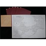
Collection of linen fold maps, Published at the Admiralty, Malby & Sons, North Polar Chart 1904, The
Collection of linen fold maps, Published at the Admiralty, Malby & Sons, North Polar Chart 1904, The Indian Ocean, Baltic Sea, 1928, The North Sea...
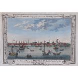
An Accurate View of Amsterdam, the Capital of the Dutch Netherlands, engraved for Millar's New
An Accurate View of Amsterdam, the Capital of the Dutch Netherlands, engraved for Millar's New Complete & Universal system of Geography, 30cm x 21...
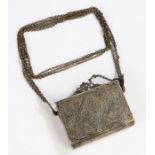
Marietta Pallis interest, Greek silver Niello box, North West Mountains region, with depictions of
Marietta Pallis interest, Greek silver Niello box, North West Mountains region, with depictions of the Crucifixion and ascension, collected circa ...
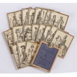
19th Century costumes of different people, the purple case covering with the text "Costumes de
19th Century costumes of different people, the purple case covering with the text "Costumes de Differents Peuples" enclosing printed sheets in mi...
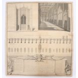
After George Vertue, circa 1748, A view of the West Front of the Chapel dedicated to St Thomas on
After George Vertue, circa 1748, A view of the West Front of the Chapel dedicated to St Thomas on London Bridge; also the inside view from West to...
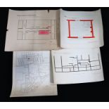
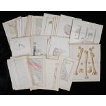
Early 20th Century hand drawn plans of criminal cases at the Old Bailey by PC Harry Woodley, to
Early 20th Century hand drawn plans of criminal cases at the Old Bailey by PC Harry Woodley, to include Plan of Room on first floor of No2 Poole S...