Refine your search
Filtered by:
- Category
- List
- Grid
A subscription to the Price Guide is required to view results for auctions ten days or older. Click here for more information


MUGGLETONIAN "CELESTIAL CHARTS".
MUGGLETONIAN "CELESTIAL CHARTS". A set of 6 "celestial charts", unbound, printed in oil colours by G. Baxter after Isaac Frost, engraved by W. P. ...
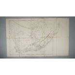
ARROWSMITH, John (1790-1873). Cape of Good Hope. London: J. Arrowsmith, 15th February 1842. Large folding engraved map on 10 sections, mounted on...
Atlas Classica, Being a Collection of Maps of the Countries Mentioned by the Ancient Authors,
Atlas Classica, Being a Collection of Maps of the Countries Mentioned by the Ancient Authors, both Sacred and Profane. London: Published by Robert...
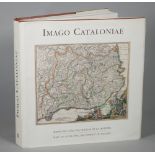
CARTOGRAPHY, Catalonia - Imago Cataloniae. Maps de Catalunya, Huellas de la Historia. Maps of Catalonia, the Imprint of History. [?Barcelona:] Gen...
![COLLINS, Greenville (1643-94, hydrographer). The Firth of Murry. [London:] 1689.](https://portal-images.azureedge.net/auctions-2019/srbe10205/images/2a563096-8376-4bf5-834c-ab0d01030a0c.jpg?w=155&h=155)
COLLINS, Greenville (1643-94, hydrographer). The Firth of Murry. [London:] 1689. Engraved sea chart of the Moray Firth, dedication to Lord Viscou...
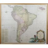
D' ANVILLE, Jean Baptisite Bourguignon (1697-1782). A Map of South America containing Tierra-Firma, Guayana, New Granada, Amazonia, Brasil, Peru,...
![[HONDIUS, Henricus (1573-1650)]. Bresse. [Amsterdam: c. 1630].](https://portal-images.azureedge.net/auctions-2019/srbe10205/images/5d2c35bf-f3bb-4429-9443-ab0d01032af5.jpg?w=155&h=155)
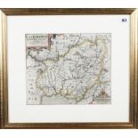
[HONDIUS, Henricus (1573-1650)]. Bresse. [Amsterdam: c. 1630]. Hand-coloured engraved map of the north east Auvergne region of France, title and ...
LONDON - Richard NEWCOURT (c.1610-1679). An Exact Delineation of the Cities of London and Westminster and the Suburbs. London: 1653 [but Edward St...
![MORDEN, Robert (1650-1703). Glocester Shire. [London: 1680].](https://portal-images.azureedge.net/auctions-2019/srbe10205/images/47a70a1f-d68f-49a6-b476-ab0d01033fac.jpg?w=155&h=155)
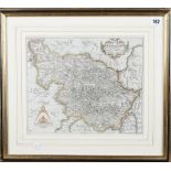
MORDEN, Robert (1650-1703). Glocester Shire. [London: 1680]. Hand-coloured engraved map of Gloucestershire, title within baroque cartouche, 350 x...
SAXTON, Christopher (c. 1540- c.1610) & William HOLE (d. 1624). Eboracensis. Comitatis pars Occidentalis vulgo West Riding. [London: c. 1608]. Ha...
SAXTON, Christopher (c. 1540-c. 1610) & William KIP. Caermardi comitatus in quo dimetiae olim habitarunt. [London: n.d. but c. 1607 or later]. Ha...
![SEALE, Richard William (d. 1785). Map of the County of Middlesex. London: [c. 1760].](https://portal-images.azureedge.net/auctions-2019/srbe10205/images/1a78aa27-ae35-42cc-b5ce-ab0d010364fa.jpg?w=155&h=155)
SEALE, Richard William (d. 1785). Map of the County of Middlesex. London: [c. 1760]. Large hand-coloured map of London and Middlesex, title and d...
![SUSSEX - [Johannes BLAEU (1596-1673)]. Suthsexia, vernacule Sussex. [Amsterdam: c. 1645 or later].](https://portal-images.azureedge.net/auctions-2019/srbe10205/images/b45f7530-9308-42f4-9f2c-ab0d010375a8.jpg?w=155&h=155)
SUSSEX - [Johannes BLAEU (1596-1673)]. Suthsexia, vernacule Sussex. [Amsterdam: c. 1645 or later].
SUSSEX - [Johannes BLAEU (1596-1673)]. Suthsexia, vernacule Sussex. [Amsterdam: c. 1645 or later]. Hand-coloured engraved map, coats-of-arms, gal...
![SUSSEX - J. & C. WALKER (publisher). Sussex. London: J. & C. Walker, [c. 1880].](https://portal-images.azureedge.net/auctions-2019/srbe10205/images/e4142b89-b945-4d12-98f0-ab0d010376c8.jpg?w=155&h=155)
SUSSEX - J. & C. WALKER (publisher). Sussex. London: J. & C. Walker, [c. 1880]. Hand-coloured engraved map, 320 x 390mm., framed and glazed. The ...
![[WELLS, Edward (1667-1727)].](https://portal-images.azureedge.net/auctions-2019/srbe10205/images/5ada508e-7d66-4cd2-9216-ab0d010385de.jpg?w=155&h=155)
[WELLS, Edward (1667-1727)].
[WELLS, Edward (1667-1727)]. A New Map of France shewing its Principal Divisions, Cheif[sic] Cities, Townes, Ports, Rivers, Mountains, &c. [Londo...
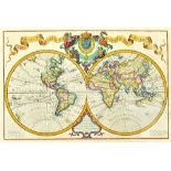
WORLD MAP - Guillaume DE L' ISLE (1675-1726), Jean COVENS (1697-1774) & Corneille MORTIER (1699-1783). Mappe Monde. A l' Usage du Roy. Nouvelleme...