
Filtered by:
- Category
- List
- Grid
A subscription to the Price Guide is required to view results for auctions ten days or older. Click here for more information
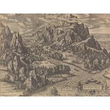

Tempe. Delineatum et aeditum auctore ab. ortelio cum privilegio decennali 1590., by Abraham Orteliu
15-3/4 x 20-1/2 in. sheet size Designed and published by Abraham Ortelius with a ten year privilege. 1590. Bird's eye view of the playground of th...
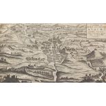
Vorstellung des Alten und Neven Athens, von dem Venetiani Schen Geographo Herrn Pat. Coronelli Verz
9-1/2 x 15 in sheet size Birds eye view map of old and new Athens, by Venetian geographer Pat Coronelli, ca. 1747. Foxing map, with full margins, ...
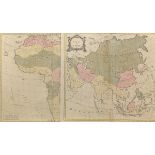
Asia 20-3/4 x 22-3/8, Africa 20-1/4 x 24-3/8 in sheet sizes London, 1754. Hand colored engraved maps from Atlas Methodique. Both with centrefold a...
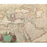
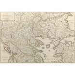
Accuratissima et Maxima Totius Turcici Imperii Tabula cum omnibus suis regionibus novissima delinea
19-1/2 x 23-1/4 sheet size Amsterdam, ca. 1703-27. The map was originally known as being by Justus Danckerts, and from 1703-1705, members of the D...
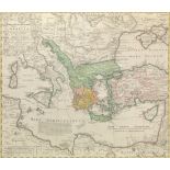
Imperii Turcici Europaei Terra, in primis Graecia cum consiniis ad intelligendos Scriptores N.T. ce
20-3/4 x 24 in sheet size. Nuremberg, 1741. Hand colored engraved map. Drawn by Joanes Christoph Harenberg for inclusion the 1752 Homann Heirs Mai...
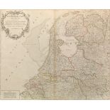
Les Provinces-Unies des Pays-Bas, que comprennent le Duche de Gueldre, les Comtes de Hollande, de Z
20 x 26-1/4 in. sheet size Paris, ca. 1755. Engraved map with outlining color by hand, map from Atlas Universal, depicting the Netherlands, identi...
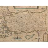
19-1/4 x 23 sheet size Amsterdam, ca. 1640's. Engraved map with outline hand color, from Atlas Novus depicting Turkey, Cyprus and the Islands in t...
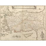
18-1/4 x 23-3/4 in sheet size Paris, 1658. A rare engraved map by Mariette, with outline hand color, originally from Atlas Novus depicting Turkey,...
22 x 30 in sheet size Paris, dated 1708. Engraved map with hand color outlining, from Atlas de Geographie, depicting Greece, Macedonia and parts o...
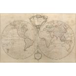
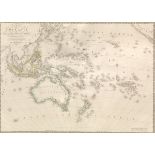
Mappe-monde dressée suivant les nouvelles relations et assujettie aux observations astronomiques by
19-3/4 x 30 in sheet size Paris, 1780. Hand colored engraved double-hemisphere map from Atlas Universale, depicting travel routes of explorers of...
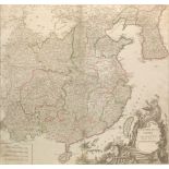
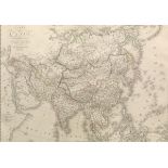
L'Empire De La Chine Dresse' d'Apres Les Cartes de l'Atlas Chinois Gilles Robert de Vaugondy (1688
20 x 26-1/4 in sheet size Paris, 1757. Hand colored map from the Atlas Universale, depicting Tartary east to include Korea or Corea and south incl...
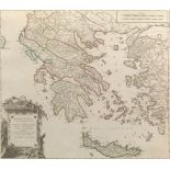
Graecia Vetus ex schardis Sansonianis desumpta, in qua Macednoia, Thessalia, Epirus, Achaia et Pelo
21-1/2 x 30 in. sheet size Paris, 1757. Hand colored engraved map from "Atlas Universel", of Greece and neighboring Islands in the Ionian and Aege...
Antiquor? Imperiorum Tabula, in qua prae coeteris, Macedonicum seu Alexandri Magni Imperium et expe
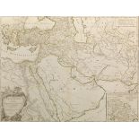
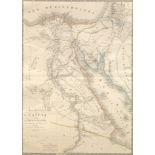
23 x 33-3/4 in sheet size Paris, 1753. Hand colored engraved atlas map, centered on Arabia and details ancient Asia Minor and the Holy Land extend...
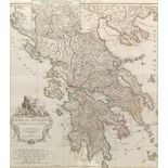
22-1/2 x 28 in. sheet size Paris, 1762. Hand colored engraved map of Greece, showing the historical regions with the surrounding islands. In the l...
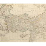
21-1/2 x 29 in. sheet size Paris, 1764. Hand colored engraved map of ancient Turkey showing the Black Sea, Mediterranean Sea, Aegean Sea and islan...
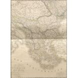
28 x 20-1/2 in sheet size Paris, dated 1822. Hand colored engraved map of the European provinces of the Ottoman Empire. Embossed publishers stamp....
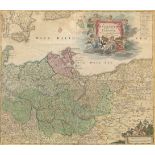
20 x 23-3/4 in sheet size Nuremburgh, ca. 1720. Hand colored engraved map depicting the 'Mark Brandenburg' with the Baltic Sea and the island of R...
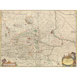
21-3/4 x 24-1/4 in sheet size Amsterdam, ca. 1681. Hand colored copper engraved atlas map with Latin text, from ?Atlas Novus?. Topographical map w...
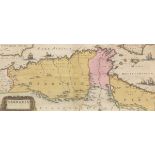
10-1/4 x 22-1/4 in sheet size Amsterdam, ca. 1665. Original hand coloring on copper engraved map of the Southern Mediterranean including Algeria, ...
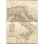
20-1/2 x 28 in sheet size Paris, dated 1820. Hand colored engraved map, plate 25, from "Atlas universel de geographie physique, politique, ancienn...
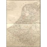
28 x 20-1/4 in. sheet size Paris, dated 1821. Hand colored engraved map, plate 16, from "Atlas universel de geographie physique, politique, ancie...
28 x 20-1/4 in. sheet size Paris, dated 1822. Hand colored engraved map, plate 32, from "Atlas universel de geographie physique, politique, ancien...
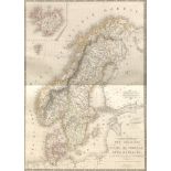
Carte Generale Des Royaumes De Suede, De Norwege Et Du Danemark, by Adrien Hubert Brue (1786-1832)
28 x 20-1/4 in.150 sheet size Paris, dated 1821. Hand colored engraved atlas map from "Atlas universel de geographie physique, politique, ancienne...
28 x 20-1/4 in sheet size Paris, dated 1820. Hand colored engraved map from "Atlas universel de geographie physique, politique, ancienne & moderne...
20-3/8 x 28 in. sheet size Paris, 1820. Hand colored engraved map from "Atlas universel de geographie physique, politique, ancienne & moderne." de...
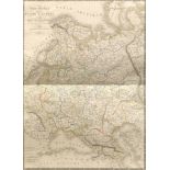
Carte Generale De La Russie D" Europe Et Du Roy me. De Polonge, by Adrien Hubert Brue (1786-1832)
28 x 20-1/2" in. sheet size Paris, 1821. Hand colored engraved atlas map from "Atlas universel de geographie physique, politique, ancienne & moder...
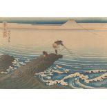
10" x 14-5/8" "Kajikazawa in Kai Province (Koshu Kajikazawa)", from the series Thirty-six Views of Mount Fuji (Fugaku sanjurokkei). Japanese wood...