Filtered by:
- Category
- List
- Grid
A subscription to the Price Guide is required to view results for auctions ten days or older. Click here for more information
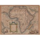

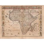
Abraham Ortelius Africae tabula novaThis is a beautiful, rare example of a landmark map of Africa
Abraham Ortelius Africae tabula novaThis is a beautiful, rare example of a landmark map of Africa that appeared in the first Atlas: Theatrum Orbis...
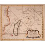
Jean Frederic Phelipeaux (1701-1781) CARTA DI TUTTE LE ISOLE CONOSCIUTE NELLE COSTE DI ZANGUEBAR E
Jean Frederic Phelipeaux (1701-1781) CARTA DI TUTTE LE ISOLE CONOSCIUTE NELLE COSTE DI ZANGUEBAR E MADAGASCARCARTA DI TUTTE LE ISOLE CONOSCIUTE NE...
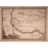
Cassini Giovanni Maria (1745-1824) Parte dell'Africa che comprende l'Alta Guinea con la NigriziaOriginal map of 1797 featuring Guinea and its Gulf...
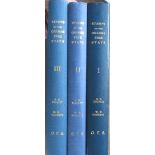
Buckley,G.D and Marriott, W.B The Stamps of the Orange Free State - 3 VolumesThree Volumes - Dark
Buckley,G.D and Marriott, W.B The Stamps of the Orange Free State - 3 VolumesThree Volumes - Dark Blue Boards with gilt blocking to spine titles. ...
John Speed Africae describedAttractively coloured this third state (1676) of John Speed's decorative
John Speed Africae describedAttractively coloured this third state (1676) of John Speed's decorative 1626 map of Africa. This is the first map of ...
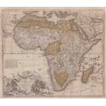
Johannes Baptista Homann Totius Africae Nova Representatio qua praeter diversos [New representation of the whole of Africa, but different]Early e...
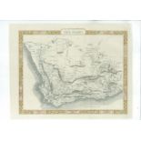
John Tallis Cape ColonyThis attractive map of the Cape Colony appeared in the Illustrated Atlas
John Tallis Cape ColonyThis attractive map of the Cape Colony appeared in the Illustrated Atlas and Modern History of the World, Geographical, Pol...
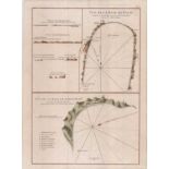
Jean Baptiste d'Apres de Mannevillette Vue de la Baye de False / Vue de la Rade de Simons-Baye.
Jean Baptiste d'Apres de Mannevillette Vue de la Baye de False / Vue de la Rade de Simons-Baye.Beautiful 1775 sea charts and silhouette views of F...
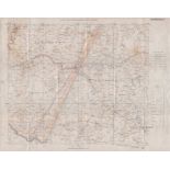
Field Intelligence Department KimberleyThis 1900 folded map of the district of Kimberley is one of
Field Intelligence Department KimberleyThis 1900 folded map of the district of Kimberley is one of the products of the Anglo-Boer War.The map show...
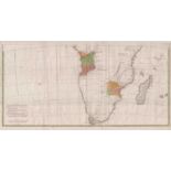
Jean Baptiste d' Anville Untitled map of Southern AfricaThis is the southern half of the landmark
Jean Baptiste d' Anville Untitled map of Southern AfricaThis is the southern half of the landmark map of Afica by d'Anville. His map was the next ...
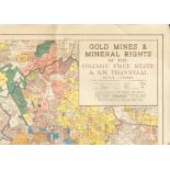
Map. GOLD MINES AND MINERAL RIGHTS OF THE ORANGE FREE STATE & S.W.TRANSVAALFull colour map mounted
Map. GOLD MINES AND MINERAL RIGHTS OF THE ORANGE FREE STATE & S.W.TRANSVAALFull colour map mounted on linen and folded (110 x860 mm), a very good ...
Jodocus Hondius II Africae Pars Meridional.Arguably the best engraved antique miniature map (13.4
Jodocus Hondius II Africae Pars Meridional.Arguably the best engraved antique miniature map (13.4 x 9.1cm) of South Africa, engraved by Jodocus Ho...
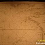
Abb?? Dicquemare (French) Carte Des C??tes Occidentales De FranceNautical chart in black and
Abb?? Dicquemare (French) Carte Des C??tes Occidentales De FranceNautical chart in black and white. Nautical chart drawn by Abbé Dicquemare for "L...
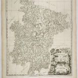
Du Halde Province de Hou-Quang. Hunan.51 x 42,5 cm de pisada y 52,5 x 48 cm de papel. Nouvel Atlas
Du Halde Province de Hou-Quang. Hunan.51 x 42,5 cm de pisada y 52,5 x 48 cm de papel. Nouvel Atlas de la Chine, de la Tartarie Chinoise et du Tibe...
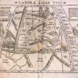
SEBASTIAN MUNSTER Tabula Asiae VIII 1545Very Good-Excellent condition despite the age of the map,
SEBASTIAN MUNSTER Tabula Asiae VIII 1545Very Good-Excellent condition despite the age of the map, without color, with losses in the margins. Descr...

Sleigh, Daniel Die Buiteposte VOC - buiteposte onder Kaapse bestuur 1652-1795'n Verersingstasie is
Sleigh, Daniel Die Buiteposte VOC - buiteposte onder Kaapse bestuur 1652-1795'n Verersingstasie is in 1652 in Tafelbaai aangele om skepe te dedien...

Pretorius (Andre) BASSING DESTINATIONS IN SOUTH AFRICA120pp. Softcover. Illustrated in colour
Pretorius (Andre) BASSING DESTINATIONS IN SOUTH AFRICA120pp. Softcover. Illustrated in colour throughout. Very good copy of this rather scarce pie...