Filtered by:
- Category
- List
- Grid
A subscription to the Price Guide is required to view results for auctions ten days or older. Click here for more information

Vincenzo Coronelli L'Africa divisa nelle sue Parti secondo le piu moderne This is the first state of
Vincenzo Coronelli L'Africa divisa nelle sue Parti secondo le piu moderne This is the first state of the beautiful map of Africa that was the firs...
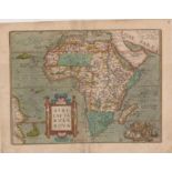
Abraham Ortelius Africae tabula nova This is a beautiful example of a landmark map of Africa that
Abraham Ortelius Africae tabula nova This is a beautiful example of a landmark map of Africa that first appeared in 1570 in the first published At...
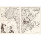
De Fer Nicolas (1646-1720) PARTIE MERIDIONALE D’AFRIQUE OU SE TROUVENT LA BASSE GUINEE LA CAFRERIE
De Fer Nicolas (1646-1720) PARTIE MERIDIONALE D’AFRIQUE OU SE TROUVENT LA BASSE GUINEE LA CAFRERIE LE MONOMOTAPA LE ZANGUEBAR ET L’ISLE DE MAD...
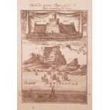
Mallet Allain Manesson (1630-1706) CAP DE BONE ESPERANCE View of Cape of Good Hope of 1719 by Allain
Mallet Allain Manesson (1630-1706) CAP DE BONE ESPERANCE View of Cape of Good Hope of 1719 by Allain Manesson Mallet. A view of the Dutch Fort of ...
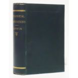
Darwin (Charles) GEOLOGICAL OBSERVATIONS Third edition. xiii + 648 pages. two folding maps and
Darwin (Charles) GEOLOGICAL OBSERVATIONS Third edition. xiii + 648 pages. two folding maps and five folding plates, publisher’s green cloth, title...

Vedder (Heinrich) and Inskeep (Adi) THE BERGDAMA An annotated translation of the German original
Vedder (Heinrich) and Inskeep (Adi) THE BERGDAMA An annotated translation of the German original with additional ethnographic material Editor: Mat...
![Giacomo Gastaldi [Giovanni Ramusio] Prima tavola This is the >465 years old, woodcut edition of](https://portal-images.azureedge.net/auctions-2019/sran10047/images/92c841ac-938b-4a75-a9c4-aa7d012ce0a0.jpg?w=155&h=155)
Giacomo Gastaldi [Giovanni Ramusio] Prima tavola This is the >465 years old, woodcut edition of
Giacomo Gastaldi [Giovanni Ramusio] Prima tavola This is the >465 years old, woodcut edition of the famous first 'upside down' map of Africa. The ...
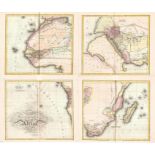
Daniel Lizars Taken from the most celebrated modern geographers AFRICA This seems to be the first
Daniel Lizars Taken from the most celebrated modern geographers AFRICA This seems to be the first time the first edition of this beautiful wall ma...
![John Seller [Jeremiah Seller and Charles Price] A chart of ye coasts of Cimbebas and Caffaria from](https://portal-images.azureedge.net/auctions-2019/sran10047/images/4357206d-819f-4b6e-a8c1-aa7d012ce29c.jpg?w=155&h=155)
John Seller [Jeremiah Seller and Charles Price] A chart of ye coasts of Cimbebas and Caffaria from
John Seller [Jeremiah Seller and Charles Price] A chart of ye coasts of Cimbebas and Caffaria from Mt. Negro to ye C. of Good Hope This is a scarc...
![Peter Kolbe [Balthazar Lakeman] Caarte van de Kaap de Goede Hoop This 1727 map is seldom available](https://portal-images.azureedge.net/auctions-2019/sran10047/images/1142817e-c121-4596-a212-aa7d012ce34d.jpg?w=155&h=155)
Peter Kolbe [Balthazar Lakeman] Caarte van de Kaap de Goede Hoop This 1727 map is seldom available
Peter Kolbe [Balthazar Lakeman] Caarte van de Kaap de Goede Hoop This 1727 map is seldom available in the market. It is from Peter Kolbe's influen...
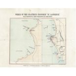
Cape Argus Wreck of the chartered troopship "St. Lawrence" Beautiful, small and uncommon lithographed chart of the Paternoster region, north of Ca...
![John Seller The Island of Jarsey [Jersey] This is a scarce 1695 miniature map of the island of](https://portal-images.azureedge.net/auctions-2019/sran10047/images/f393cff5-d31e-46ea-848d-aa7d012ce4cf.jpg?w=155&h=155)
John Seller The Island of Jarsey [Jersey] This is a scarce 1695 miniature map of the island of
John Seller The Island of Jarsey [Jersey] This is a scarce 1695 miniature map of the island of Jersey by the famous English cartographer, John Sel...
Giobattista Albrizzi Carta Geografica Capo del Buona Speranza This attractive, uncommon map depicts the second early expansion of the Cape of Good...
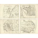
Giovanni Battista Nicolosi Africa An'upside down' wall map of Africa in its first state (edition).
Giovanni Battista Nicolosi Africa An'upside down' wall map of Africa in its first state (edition). All four panels of the map are in fine conditio...
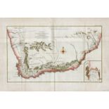
John Cary Cape of Good Hope This is a beautiful and historically important map of the Cape Colony (
John Cary Cape of Good Hope This is a beautiful and historically important map of the Cape Colony (the map is in original colour). Engraved on cop...
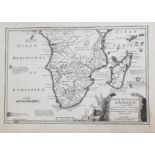
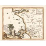
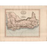
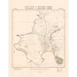
William Paterson Carte de l'extremite meridionale de L'AFRIQUE William Paterson undertook four
William Paterson Carte de l'extremite meridionale de L'AFRIQUE William Paterson undertook four extensive journeys in the Cape of Good Hope between...
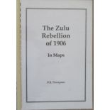
Thompson.P.S The Zulu Rebellion of 1906- In Maps Spiral edition with stiff laminated boards, black
Thompson.P.S The Zulu Rebellion of 1906- In Maps Spiral edition with stiff laminated boards, black letter to front cover. This booklet is a public...
Surveyor General Hout Bay 1:12, 500 This map was the output of a 1950 trigonometric survey of Hout
Surveyor General Hout Bay 1:12, 500 This map was the output of a 1950 trigonometric survey of Hout Bay (printed 1952). The map also shows the earl...
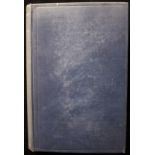
Hugh Marshall Hole The Jameson Raid (1930) Publisher's blue cloth binding, cartoon frontispiece
Hugh Marshall Hole The Jameson Raid (1930) Publisher's blue cloth binding, cartoon frontispiece Jameson. 306pp, illustrated + two maps. Near fine...