2
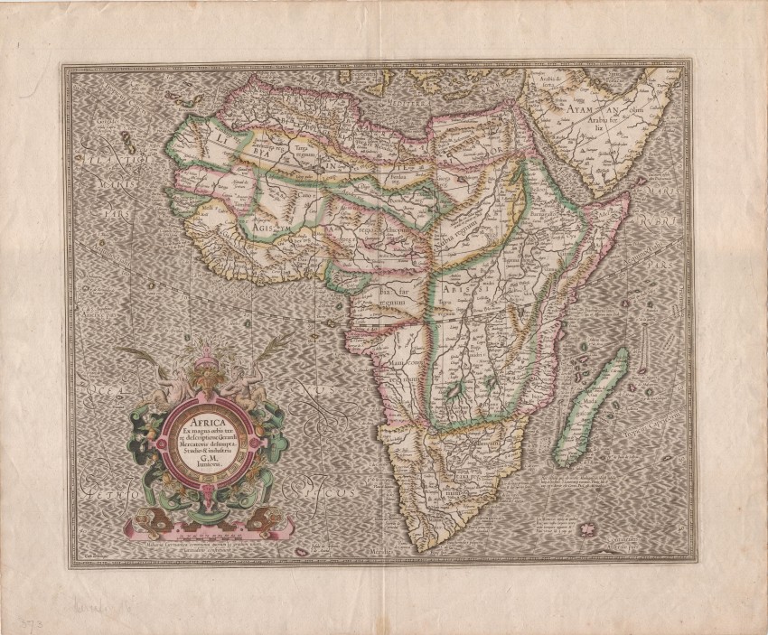
Gerard Mercator Junioris AfricaThis striking map is one of the most well researched and
1/2


Description
Gerard Mercator Junioris Africa
J Hondius and C Claesz
Amsterdam
1619
Very good
47 x 38 cm
For further details and and to bid visit AntiquarianAuctions.com
This striking map is one of the most well researched and influential maps of the continent map to the end of the 16th century. It was produced by Mercator's grandson and first was published in 1595, the year after his grandfather's map. This uncommonly available example of the map was included in the 1619 French edition of the Gerardi Mercatoris Atlas published by Jodocus Hondius and Cornelis Claesz, to whom the Mercator family sold the plate.
The accuracy of the coastline was unsurpassed for many years. Much of the interior of Africa is in the Ptolemy tradition with the White Nile River shown to arise from the two lakes near the Mountains of the Moon. Drawing from Portuguese texts, Mercator shows European advance into the interior, such as exploration along the Cuama (Zambezi) River and Ca. Portogal (the Portuguese Fort), which is between the Spirito and Cuama rivers.
Mercator avoided the common practice at the time of including 'elephants for want of towns'; the only decorative item in the continent is the legendary priest-king Prester John, who is seated in Ethiopia. The decorative cartouche includes fruit and two satyrs. The map is beautifully engraved and the sea is depicted in the moiré pattern for which Mercator is well known.
See lot 191 for the Hondius map of Africa that was included in the Gerardi Mercatoris Atlas.
Reference Richard Betz. Mapping of Africa, HES and De Graaf, 2007, #31
J Hondius and C Claesz
Amsterdam
1619
Very good
47 x 38 cm
For further details and and to bid visit AntiquarianAuctions.com
Auction Details
Shipping
T&Cs & Important Info
Ask seller a question
Gerard Mercator Junioris Africa
J Hondius and C Claesz
Amsterdam
1619
Very good
47 x 38 cm
For further details and and to bid visit AntiquarianAuctions.com
This striking map is one of the most well researched and influential maps of the continent map to the end of the 16th century. It was produced by Mercator's grandson and first was published in 1595, the year after his grandfather's map. This uncommonly available example of the map was included in the 1619 French edition of the Gerardi Mercatoris Atlas published by Jodocus Hondius and Cornelis Claesz, to whom the Mercator family sold the plate.
The accuracy of the coastline was unsurpassed for many years. Much of the interior of Africa is in the Ptolemy tradition with the White Nile River shown to arise from the two lakes near the Mountains of the Moon. Drawing from Portuguese texts, Mercator shows European advance into the interior, such as exploration along the Cuama (Zambezi) River and Ca. Portogal (the Portuguese Fort), which is between the Spirito and Cuama rivers.
Mercator avoided the common practice at the time of including 'elephants for want of towns'; the only decorative item in the continent is the legendary priest-king Prester John, who is seated in Ethiopia. The decorative cartouche includes fruit and two satyrs. The map is beautifully engraved and the sea is depicted in the moiré pattern for which Mercator is well known.
See lot 191 for the Hondius map of Africa that was included in the Gerardi Mercatoris Atlas.
Reference Richard Betz. Mapping of Africa, HES and De Graaf, 2007, #31
J Hondius and C Claesz
Amsterdam
1619
Very good
47 x 38 cm
For further details and and to bid visit AntiquarianAuctions.com
Online Rare Books, Maps & Prints and Photography Auction
Sale Date(s)
Venue Address
Online only auction
AntiquarianAuctions.com
-
-
United Kingdom
General delivery information available from the auctioneer
Registration on AntiquarianAuctions.com is free of charge.
As a successful bidder you will receive an invoice from the seller after the auction. The seller will only invoice the final selling price. We do not charge a buyer’s premium and no VAT applies.
The buyer pays for shipping and insurance costs which can be requested from the seller before the end of the sale.
Important Information
This is an online only auction. Please visit AntiquarianAuctions.com for further information about a lot and to bid.
Terms & Conditions
There is no buyer’s premium charged on AntiquarianAuctions.com
AntiquarianAuctions.com is an online rare book auction website. All lots are listed by recognised booksellers who have been vetted before being accepted to sell on the site. This allows buyers to bid with confidence and ensures that lots are accurately described.
Bidding will begin on 11 October at 5.30 pm (UK time) and ends on 18 October at 5.30 pm (UK time). Please follow the countdown on AntiquarianAuctions.com.
Please visit AntiquarianAuctions.com for further information about a lot and to bid