Filtered by:
- Category
- List
- Grid
A subscription to the Price Guide is required to view results for auctions ten days or older. Click here for more information
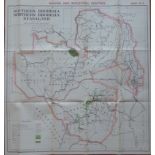

His Majesty's Stationery Office RHODESIA-NYASALAND Royal Commission Report List of maps: Map No. 1 -
His Majesty's Stationery Office RHODESIA-NYASALAND Royal Commission Report List of maps: Map No. 1 - Sketch Map showing communications (including ...
Lorenz Fries Tabula noua partis africæ (South Africa) This is the first printed map of Southern
Lorenz Fries Tabula noua partis africæ (South Africa) This is the first printed map of Southern Africa reasonably available to collectors. It is ...
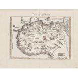
Lorenz Fries Tabula noua partis africæ (West Africa) This map of north-west Africa is the companion
Lorenz Fries Tabula noua partis africæ (West Africa) This map of north-west Africa is the companion of the map of South Africa, with the same pag...
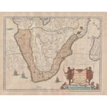
Johannes Janssonius Ætiopia inferior, vel exterior This is one of the landmark maps in the history of mapping of Southern Africa. The map first w...
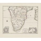
R & I Ottens Nieuwe Caarte van Kaaap de Goede Hoop an't Zuyderdeel van Africa This is a very
R & I Ottens Nieuwe Caarte van Kaaap de Goede Hoop an't Zuyderdeel van Africa This is a very uncommon map in pristine condition by the famous Ottt...
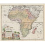
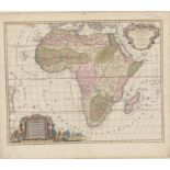
Homann Heirs Africa Secundum Legitimas Projectionis Stereographicæ This map was produced in
Homann Heirs Africa Secundum Legitimas Projectionis Stereographicæ This map was produced in Nuremburg for the heirs of Johan Baptist Homann (166...
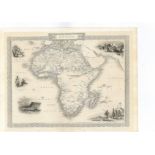
John Tallis Africa Map of Africa with decorative border and five vignettes - uncoloured as printed
John Tallis Africa Map of Africa with decorative border and five vignettes - uncoloured as printed for John Tallis. The map featured in an exhibit...
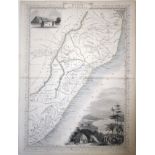
John Tallis Natal and Kaffraria Tallis's map of Natal and Kaffraria, with vignettes of Port Natal
John Tallis Natal and Kaffraria Tallis's map of Natal and Kaffraria, with vignettes of Port Natal and Durban atlas. This map was printed from a ...
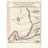
Nicolas Bellin Carte de la Baye de la Table et Rade du Cap de Bonne Esperance Hand-coloured example of this 18th century depiction of Table Bay an...
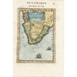
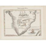
Alain Mallet Monomatapa et la Cafrerie Beautiful, coloured miniature map of South Africa from a
Alain Mallet Monomatapa et la Cafrerie Beautiful, coloured miniature map of South Africa from a significant atlas published in 1783 in Alain Mall...
Jan Barend Elwe L' Afrique Divisee en ses Empires, Royaumes et Etats Stunningly beautiful map of
Jan Barend Elwe L' Afrique Divisee en ses Empires, Royaumes et Etats Stunningly beautiful map of Africa printed from a copperplate first used almo...
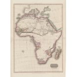
John Pinkerton Africa Pinkerton’s map of Africa, is arguably the best detailed map of Africa from
John Pinkerton Africa Pinkerton’s map of Africa, is arguably the best detailed map of Africa from the period - and superior to the maps of Cary an...

Johannes Janssonius (Valk and Schenk) Ætiopia inferior vel exterior Johannes Janssonius (Valk &
Johannes Janssonius (Valk and Schenk) Ætiopia inferior vel exterior Johannes Janssonius (Valk & Schenk) Aethiopia inferior vel superior is an at...
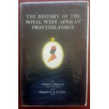
Colonel A. Haywood & Brigadier F.A.S. Clarke The History of the Royal West African Frontier Force
Colonel A. Haywood & Brigadier F.A.S. Clarke The History of the Royal West African Frontier Force 540p. Fold-out maps. Black and white photographs...