Refine your search
Estimate
Category
- Books & Periodicals (157)
- Prints (97)
- Maps (53)
- Watercolours (28)
- Arms, Armour & Militaria (17)
- Oil, Acrylic paintings & Mixed Media (10)
- Drawings & Pastels (8)
- Sculpture (8)
- Stamps (8)
- Photographs (7)
- Bank notes (5)
- Clocks (3)
- Coins (3)
- Collectables (3)
- Glassware (3)
- Models, Toys, Dolls & Games (3)
- Silver & Silver-plated items (3)
- Sporting Memorabilia & Equipment (3)
- Scientific Instruments (2)
- Vintage Fashion (2)
- Wines & Spirits (2)
- Classic Cars, Motorcycles & Automobilia (1)
- Furniture (1)
- Islamic Works of Art (1)
- Japanese Works of Art (1)
- Kitchenalia (1)
- Salvage & Architectural Antiques (1)
- Textiles (1)
- Tools (1)
- Watches & Watch accessories (1)
- Writing Instruments (1)
Filtered by:
- Creator / Brand
- List
- Grid
A subscription to the Price Guide is required to view results for auctions ten days or older. Click here for more information

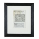
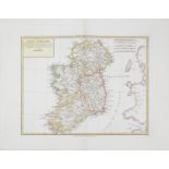
GERARD MERCATOR (1512-1592) A set of five maps c.185 x 133mm From the English edition of Mercators
GERARD MERCATOR (1512-1592) A set of five maps c.185 x 133mm From the English edition of Mercators Atlas Minor this edition 1635 Abl P166 (1-5) P...
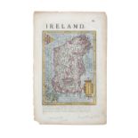
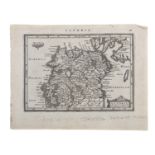
GEORGE BICKHAM (1684-1758) A map of Ireland 140 x 230mm From his British Monarchy, published in
GEORGE BICKHAM (1684-1758) A map of Ireland 140 x 230mm From his British Monarchy, published in London 1754 Abl P79 Provenance: The Collection of...
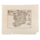
S.ROYIERS AFTER JACOB HONDIUS Hibernia - miniature 95 x 130mm From the 1616 edition by Jacob Hondius
S.ROYIERS AFTER JACOB HONDIUS Hibernia - miniature 95 x 130mm From the 1616 edition by Jacob Hondius of the Tabulnom Geographcarum Contractum; t...
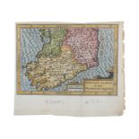
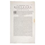
JANSSON, AFTER MERCATOR (1512 - 1592) Ultonia and Momonia et Lagenia Ireland in two sections 140 x
JANSSON, AFTER MERCATOR (1512 - 1592) Ultonia and Momonia et Lagenia Ireland in two sections 140 x 190mm (2) Provenance: The Collection of Hugh ...
JANSSON, AFTER MERCATOR (1512 - 1592) Utonia, Momonia and Lagenia Ireland in two sections 140 x
JANSSON, AFTER MERCATOR (1512 - 1592) Utonia, Momonia and Lagenia Ireland in two sections 140 x 190mm (2) Provenance: The Collection of Hugh and...
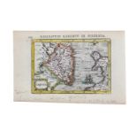
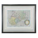
PERTUS BERTUS (1565-1629) Descripto lageniae in Hibernia Colour engraving, 132 x 93mm Abl P210
PERTUS BERTUS (1565-1629) Descripto lageniae in Hibernia Colour engraving, 132 x 93mm Abl P210 Provenance: The Collection of Hugh and Anne Iremon...
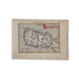
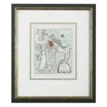
ABRAHAM ORTELIUS (1527 - 1598) Irlanda - miniature 75 x 105mm Plate 3, engraved by Philip Galle
ABRAHAM ORTELIUS (1527 - 1598) Irlanda - miniature 75 x 105mm Plate 3, engraved by Philip Galle Abl P96 Provenance: The Collection of Hugh and An...
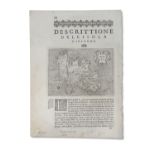
THOMAS PORCACCHI (1530-1585) Descrittione del L'Isola D' Irlanda 150 x 110mm From L'Isole Piu Fanose
THOMAS PORCACCHI (1530-1585) Descrittione del L'Isola D' Irlanda 150 x 110mm From L'Isole Piu Fanose del Mondo... Published in Venice by Thomas Po...
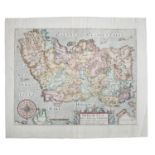
JANSSON AFTER GERARD MERCATOR (1512 - 1594) Irlandia Regnum 190 x 260mm Jansson Plates from Mercators Altas Minor Provenance: The Collection of H...
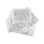
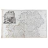
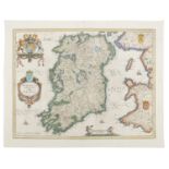
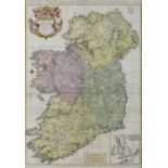
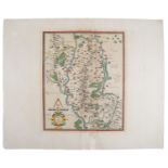
HERMAN MOLL (1654 - 1734) Counties of Ireland, 1728, including four provinces (17) Each, 210 x 270mm
HERMAN MOLL (1654 - 1734) Counties of Ireland, 1728, including four provinces (17) Each, 210 x 270mm Abl P20 Provenance: The Collection of Hugh ...
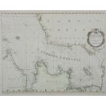
C.A. BEVEY (FRENCH, 18TH CENTURY) A Chart of the West Coast of Ireland with a Vignette of Kinsale
C.A. BEVEY (FRENCH, 18TH CENTURY) A Chart of the West Coast of Ireland with a Vignette of Kinsale Harbour Engraving, 680 x 990mm Provenance: The ...
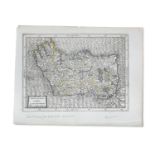
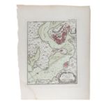
PIETER SCHENK (1660-1717) The Counties of Leinster Colour engraving, sheet 530 x 810mm Provenance:
PIETER SCHENK (1660-1717) The Counties of Leinster Colour engraving, sheet 530 x 810mm Provenance: The Collection of Hugh and Anne Iremonger
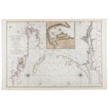
PIETER MORTIER III (1735-1781) Chart of Galway Bay and the Shannon Estuary, with Vignette of Kinsale
PIETER MORTIER III (1735-1781) Chart of Galway Bay and the Shannon Estuary, with Vignette of Kinsale Harbour 865 x 595mm This chart is from Le Nep...
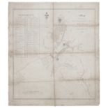
WILSON POLLON Map of the Parts of Corporation Lands of Naas Recently Recovered by The Right Hon.
WILSON POLLON Map of the Parts of Corporation Lands of Naas Recently Recovered by The Right Hon. John, Earl of Mayo, 1822 Pen and ink, 600 x 530mm...
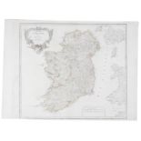
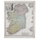
ROBERT DE VAUGONDY (1688-1766) Map of Ireland, 'Royaume d'Irlande' 490 x 620mm; together with
ROBERT DE VAUGONDY (1688-1766) Map of Ireland, 'Royaume d'Irlande' 490 x 620mm; together with another. (2) Provenance: The Collection of Hugh an...
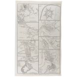
A COLLECTION OF 18TH AND 19TH CENTURY MAPS OF THE PRINCIPAL IRISH TOWNS, FORTS AND HARBOURS Provenance: The Collection of Hugh and Anne Iremonger...
PIETER VAN DER AA (1659-1733) L'Irlande, Suivant les Nouvelles Observations Engraving, 270 x 340mm
PIETER VAN DER AA (1659-1733) L'Irlande, Suivant les Nouvelles Observations Engraving, 270 x 340mm Provenance: The Collection of Hugh and Anne Ir...
HENRI ABRAHAM CHATELAIN (1684-1743) Carte Ancienne et Modern De Irlande avec Quelques Remarques (
HENRI ABRAHAM CHATELAIN (1684-1743) Carte Ancienne et Modern De Irlande avec Quelques Remarques (1708) 450 x 340mm. (2) Provenance: The Collectio...
A COLLECTION OF MAPS AND PLANS FROM PAUL DE RAPINS 'THE HISTORY OF ENGLAND', including the Plan of
A COLLECTION OF MAPS AND PLANS FROM PAUL DE RAPINS 'THE HISTORY OF ENGLAND', including the Plan of the City of Dunkirk; Plan of the City of Boucha...
AFTER JOHN ROCQUE (1709-1762) A Map of the Kingdom of Ireland Top half of a two section map, 620 x
AFTER JOHN ROCQUE (1709-1762) A Map of the Kingdom of Ireland Top half of a two section map, 620 x 980mm Provenance: The Collection of Hugh and A...
JOANNEM JANSSONIUM (1588-1664) Hibernia / Regnum / Vulgo / Ireland Colour engraving, 395 x 510mm
JOANNEM JANSSONIUM (1588-1664) Hibernia / Regnum / Vulgo / Ireland Colour engraving, 395 x 510mm Provenance: The Collection of Hugh and Anne Irem...
ISAAK TIRION (1705-1765) Nieuwe Kaart / Van / Ierland/ Te Amsterdam. Engraving, 270 x 320mm; Together with an engraving of Kinsale Harbour. (2) ...
D. CORBETT A Plan of the City of Cork in 1750 Print, 410 x 510mm Provenance: The Collection of
D. CORBETT A Plan of the City of Cork in 1750 Print, 410 x 510mm Provenance: The Collection of Hugh and Anne Iremonger
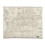
EDWARD WELLS (1667-1727) A New Map of Ancient Germany, Rhaetia, Vindelicia and Noricum Colour
EDWARD WELLS (1667-1727) A New Map of Ancient Germany, Rhaetia, Vindelicia and Noricum Colour engraving, 420 x 530mm Provenance: The Collection o...
THOMAS DA CASTIGLIONE PORACCHI (1530 - 1585) Descrizione dell' isola di Hibernia 260 x 180mm From Le
THOMAS DA CASTIGLIONE PORACCHI (1530 - 1585) Descrizione dell' isola di Hibernia 260 x 180mm From Le isole piu famose del mondo descritta da Tho...
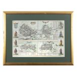
GEORGE BRAUN (1541 - 1622) & FRANZ HOGENBERG (1535 - 1590) Galway, Dublin, Limerick and Cork, 310
GEORGE BRAUN (1541 - 1622) & FRANZ HOGENBERG (1535 - 1590) Galway, Dublin, Limerick and Cork, 310 x 430mm From Civitates Orbi Terrarum, published,...
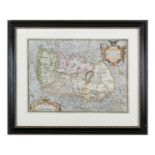
ABRAHAM ORTELIUS (1527 - 1598) Hiberniae Britannicae Insulae, Nova Descriptio 350 x 490mm From
ABRAHAM ORTELIUS (1527 - 1598) Hiberniae Britannicae Insulae, Nova Descriptio 350 x 490mm From Theatrum Orbis Terrarum (the first time a collectio...
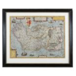
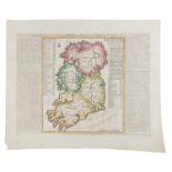
ABRAHAM ORTELIUS, PUBLISHED BY JOANNES BAPTISTA VRIENTS (ANTWERP 1603-1612) IRLANDAE, ACCURATA
ABRAHAM ORTELIUS, PUBLISHED BY JOANNES BAPTISTA VRIENTS (ANTWERP 1603-1612) IRLANDAE, ACCURATA DESCRIPTIO, Auctore Baptista Boazio, Original hand...
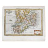
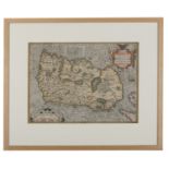
MATTHIAS QUAD (1557 - 1613) Map of Ireland 305 x 215mm From Fasciculus Geographicus Complectens,
MATTHIAS QUAD (1557 - 1613) Map of Ireland 305 x 215mm From Fasciculus Geographicus Complectens, published in Cologne in 1608 Abl P222 Although Q...
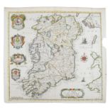
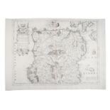
JOHN SPEEDE (1551/2 - 1629) A matched set of five maps including: The Kingdom of Ireland The Province of Muster The Province of Leinster The Pro...
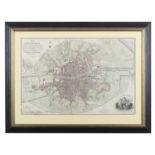
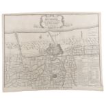
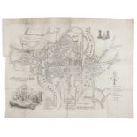
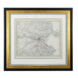
WILLIAM FADEN (1749 - 1836) A Plan of the City of Dublin as Surveyed 500 x 750mm Published by W.
WILLIAM FADEN (1749 - 1836) A Plan of the City of Dublin as Surveyed 500 x 750mm Published by W. Faden Geographer to the King, 1797, at Charing Cr...
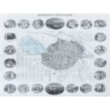
D.E. HEFFERNAN (19TH CENTURY) Dublin & Suburbs, a separate publication 530 x 730mm Published 1st
D.E. HEFFERNAN (19TH CENTURY) Dublin & Suburbs, a separate publication 530 x 730mm Published 1st June 1868 by D. Heffernan Civil Engineer 12 Charl...
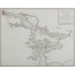
JACQUES-NICOLAS BELLIN (1703 - 1772) Plan de Galloway et ses Environs 180 x 215mm From Le Petit
JACQUES-NICOLAS BELLIN (1703 - 1772) Plan de Galloway et ses Environs 180 x 215mm From Le Petit Atlas Maritime Vol. IV, Published by Bellin Pa...
B. R DAVIES The Environs of Dublin Engraving, 330 x 400mm Published under the superintendence of the
B. R DAVIES The Environs of Dublin Engraving, 330 x 400mm Published under the superintendence of the Society for the Diffusion of Useful Knowle...
GERARD MERCATOR (1512 - 1594) IRLAN/DIAE/REGN/VM Map of the Southern Half of Ireland, 450 x 470mm
GERARD MERCATOR (1512 - 1594) IRLAN/DIAE/REGN/VM Map of the Southern Half of Ireland, 450 x 470mm First state German edition (1609)
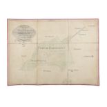
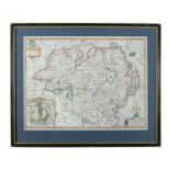
JAMES VAUGHAN (19TH CENTURY) A Survey of part of Painstown Yellowleas in the Barony of Morgallion
JAMES VAUGHAN (19TH CENTURY) A Survey of part of Painstown Yellowleas in the Barony of Morgallion and County of Meath, the Estate of Thomas Bligh,...
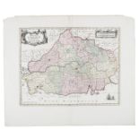
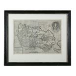
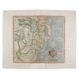
D. A BEAUFORT (1774-1857) Map of the Diocese of Meath, Dedicated to the Lord Bishop and Clergy of
D. A BEAUFORT (1774-1857) Map of the Diocese of Meath, Dedicated to the Lord Bishop and Clergy of the Diocese of Meath (within a decorated cartouc...
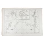
GREENVILLE COLLINS (1653-1694) A Chart of St. George's Channel, 1693 610 x 500 mm From Great Britain's Coasting Pilot. First published in 1693.
GREENVILLE COLLINS (1653 - 1694) Rade et Port de Corke en Irlande 530 x 420 mm From a French edition
GREENVILLE COLLINS (1653 - 1694) Rade et Port de Corke en Irlande 530 x 420 mm From a French edition of Greenville Collins' Great Britain's Coas...
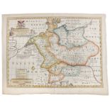
H. JAILLOT (1632 - 1712) Le Royaume D'Irlande (1693), divise en ses Quatre Provinces, qui font la
H. JAILLOT (1632 - 1712) Le Royaume D'Irlande (1693), divise en ses Quatre Provinces, qui font la Lagenie, L'Vltonie, Connacie, et Momonie....; Dr...
ABRAHAM ORTELIUS (1527 - 1598) Hiberniæ BritannicæA Map of Ireland from the 1588 Spanish edition
ABRAHAM ORTELIUS (1527 - 1598) Hiberniæ BritannicæA Map of Ireland from the 1588 Spanish edition of Theatrum Orbis Terrarum Colour, 480 x 360 mm A...
GERARD MERCATOR (1512 - 1594) Map of Barony of Idrone, Vdrone Irlandiæ in Catherlagh Baronia, 17th
GERARD MERCATOR (1512 - 1594) Map of Barony of Idrone, Vdrone Irlandiæ in Catherlagh Baronia, 17th century, Engraving, 340 x 280mm Published in M...
WILLIAM HOLE (FL. 1607-1646) Hiberniæ 310 x 360mm From Camden's Britannia. Sixth edition (1607).
WILLIAM HOLE (FL. 1607-1646) Hiberniæ 310 x 360mm From Camden's Britannia. Sixth edition (1607). Based on Mercator's map (1595). Abl P236. ...[mo...
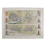
GEORG BRAUN AND FRANZ HOGENBERG Town Plans of Galway, Dublin, Limerick and Cork 310 x 420mm From
GEORG BRAUN AND FRANZ HOGENBERG Town Plans of Galway, Dublin, Limerick and Cork 310 x 420mm From their Civitates Orbis Terrarum (1618). French te...
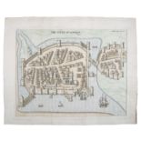
STAFFORD'S PACATA HIBERNIA The Cittie of Limerick Handcoloured map, 310 x 390mm
A MAP OF IRELAND, undated with title top lhs reads 'Regin HIBERNIAE accurate tabula per Hermanum
A MAP OF IRELAND, undated with title top lhs reads 'Regin HIBERNIAE accurate tabula per Hermanum Moll recognita a C. Weigelio Nurunberga'. Scale i...
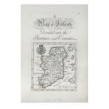
RICHARD BLOME (1635-1705) A Map of Ireland Hancoloured, 390 x 375mm From his Britannia, first
RICHARD BLOME (1635-1705) A Map of Ireland Hancoloured, 390 x 375mm From his Britannia, first published in 1673. The maps are based on John Speed....
GERARD MERCATOR (1512 - 1594) Ultonia Handcoloured map 350 x 380mm French edition, 1628
GERARD MERCATOR (1512 - 1594) Udrone. Handcoloured map, 350 x 280mm Italian edition, 1628
VINCENZO MARIA CORONELLI (1650-1718) A Map of Ireland in Two Halves, North & South (1693) From
VINCENZO MARIA CORONELLI (1650-1718) A Map of Ireland in Two Halves, North & South (1693) From Vol. II of his Isolario Dell Atlante Veneto (1697)....
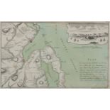
GABRIEL NIKOLAUS RASPE (1712 - 1785) Plan der Gegend von Irrland, wo Ao. 1760 den 18 Febr: de See
GABRIEL NIKOLAUS RASPE (1712 - 1785) Plan der Gegend von Irrland, wo Ao. 1760 den 18 Febr: de See Aranturier u. Capt. Thurot Bey A Gelandet und Ca...
HERMANN MOLL (1651-1732) A collection of maps of various parts of the world including a general
HERMANN MOLL (1651-1732) A collection of maps of various parts of the world including a general map of Great Britain and Ireland; France; a map of...
HERMANN MOLL (1655-1732) Ireland / Divided into its Provinces and Counties Herman Moll 1728 310mm
HERMANN MOLL (1655-1732) Ireland / Divided into its Provinces and Counties Herman Moll 1728 310mm x 250mm; Together with a new and correct map of ...
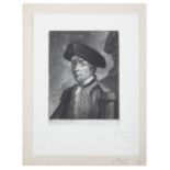
E GOSSENIN A portrait of John Paul Jones, bust length (Naval commander of the first United States
E GOSSENIN A portrait of John Paul Jones, bust length (Naval commander of the first United States Navy) Mezzotint, 18 x 13.5cm; together with a co...
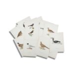
AFTER THE VON WRIGHT BROTHERS (SWEDISH-FINNISH 19TH CENTURY) A collection of 40 lithographs of birds
AFTER THE VON WRIGHT BROTHERS (SWEDISH-FINNISH 19TH CENTURY) A collection of 40 lithographs of birds from 'Svenska Fåglar' (Swedish Birds), by Mag...
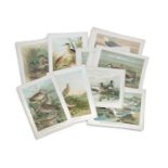
CONTINENTAL SCHOOL A collection of Lithographs and Prints of birds and wildlife Circa 40 prints,
CONTINENTAL SCHOOL A collection of Lithographs and Prints of birds and wildlife Circa 40 prints, 29 x 40cm Provenance: The Collection of Hugh an...
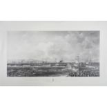
AFTER MATTHEW KENDRICK (c.1797-1874) The Departure of the Queen and the Royal Squadron Print (
AFTER MATTHEW KENDRICK (c.1797-1874) The Departure of the Queen and the Royal Squadron Print (reissue), 87 x 107cm Provenance: The Collection of ...
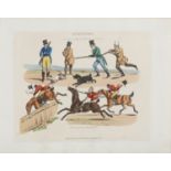
AFTER HENRY ALKEN (1785-1851) Symptoms of Being Amused (1822) Coloured etchings, xxcm. (30) Published by Thomas McLean, Haymarket, London Provena...
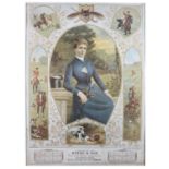
AN UNUSUAL LATE VICTORIAN CALENDAR FOR BYRNE & SONS TEA & WINE IMPORTS, 1985, decorated with hunting
AN UNUSUAL LATE VICTORIAN CALENDAR FOR BYRNE & SONS TEA & WINE IMPORTS, 1985, decorated with hunting vignettes, 'Mistress of Hounds', coloured lit...
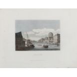
A COLLECTION OF VARIOUS ENGRAVED VIEWS OF IRELAND, including: 'View of City of Dublin from Magazine Hill in Phoenix Park; 'A View of Ringsend, Iri...