Keine Abbildung Los 2021 Set of six framed WWII original hand sketched D-Day weather forecast charts dating from the 3rd to 2021Set of six framed WWII original hand sketched D-Day weather forecast charts dating from the 3rd to John Rolfe Auctions Set of six framed WWII original hand sketched D-Day weather forecast charts dating from the 3rd to the 7th of June, Acquired by Captain David Davi... Auf die Merkliste Live
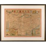
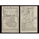
Mindestpreis nicht eingehalten Keine Abbildung Los 212 Bowen 290 Yrs Old Detailed Road Map Whitby to Durham Newcastle North East. 212Bowen 290 Yrs Old Detailed Road Map Whitby to Durham Newcastle North East. William George Title: Bowen 290 Yrs Old Detailed Road Map Whitby to Durham Newcastle North East. Description: Bowen 290 Yrs Old Detailed Road Map ... Auf die Merkliste Timed
Keine Abbildung Los 27 An old OS map of The Isle of Wight 27An old OS map of The Isle of Wight HRD Auction Rooms Ltd An old OS map of The Isle of Wight Auf die Merkliste Live
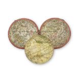
Keine Abbildung Los 24 A 2 ¾-inch terrestrial pocket globe after Herman Moll, English, circa 1775, 24A 2 ¾-inch terrestrial pocket globe after Herman Moll, English, circa 1775, Bonhams A 2 ¾-inch terrestrial pocket globe after Herman Moll, English, circa 1775, the rectangular cartouche inscribed A Correct Globe With The New D... Auf die Merkliste Live
Mindestpreis nicht eingehalten Keine Abbildung Los 325 12 MAPS OF INDIA 32512 MAPS OF INDIA Olympia Auctions Timed 12 Maps of India Survey of India early 20th century 12 canvas-backed colour maps. English Good, used condition. Auf die Merkliste Timed
Keine Abbildung Los 361 'The Map of The Isle of Wight' by A BRANNON - a pr 361'The Map of The Isle of Wight' by A BRANNON - a pr HRD Auction Rooms Ltd 'The Map of The Isle of Wight' by A BRANNON - a print - framed and glazed Auf die Merkliste Live
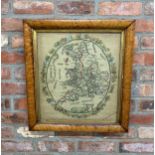
Keine Abbildung Los 3541 Large framed sampler tapestry depicting United Kingdom map surrounded by floral wreath , Signed 3541Large framed sampler tapestry depicting United Kingdom map surrounded by floral wreath , Signed John Rolfe Auctions Large framed sampler tapestry depicting United Kingdom map surrounded by floral wreath , Signed Carolene Everett & dated 1835, H 61cm x 57cm Auf die Merkliste Live
Keine Abbildung Los 1386 TWO LEATHER CASES OF JOHNSTONS THREE MILES TO INCH MAPS, ONE CONTAINING MAPS OF SCOTLAND AND THE 1386TWO LEATHER CASES OF JOHNSTONS THREE MILES TO INCH MAPS, ONE CONTAINING MAPS OF SCOTLAND AND THE JS Fine Art Auctioneers & Valuers TWO LEATHER CASES OF JOHNSTONS THREE MILES TO INCH MAPS, ONE CONTAINING MAPS OF SCOTLAND AND THE OTHER OF ENGLAND AND WALES Auf die Merkliste Live
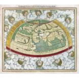
Keine Abbildung Los 1039 WORLD MAP -- "PTOLEMEISCH GENERAL TAFEL / die halbe Kugel der Welt begreiffende". (Basel 1039WORLD MAP -- "PTOLEMEISCH GENERAL TAFEL / die halbe Kugel der Welt begreiffende". (Basel Burgersdijk & Niermans WORLD MAP -- "PTOLEMEISCH GENERAL TAFEL / die halbe Kugel der Welt begreiffende". (Basel, c. 1590). Handcold. woodcut double-page map from S. Muns... Auf die Merkliste Live
Keine Abbildung Los 928 BELARUS -- MANUSCRIPT MAP of the Belarusian city of Polotsk. (1786). Plan of 928BELARUS -- MANUSCRIPT MAP of the Belarusian city of Polotsk. (1786). Plan of Burgersdijk & Niermans BELARUS -- MANUSCRIPT MAP of the Belarusian city of Polotsk. (1786). Plan of Polotsk drawn on blueish paper by Ivan Abramovich (?), cold. by hand,... Auf die Merkliste Live
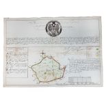
Keine Abbildung Los 3213 WORSLEY, Richard. The History of the Isle of Wight. London: A. Hamilton, 1781. First edition, 4to ( 3213WORSLEY, Richard. The History of the Isle of Wight. London: A. Hamilton, 1781. First edition, 4to ( Toovey's WORSLEY, Richard. The History of the Isle of Wight. London: A. Hamilton, 1781. First edition, 4to (307 x 229mm.) Large folding engraved map of Isl... Auf die Merkliste Live
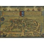
Keine Abbildung Los 89 JOHN SPEED coloured 1610 copper engraved map - entitled in cartouche 'Caermarden, Both Shyre and 89JOHN SPEED coloured 1610 copper engraved map - entitled in cartouche 'Caermarden, Both Shyre and Rogers Jones & Co JOHN SPEED coloured 1610 copper engraved map - entitled in cartouche 'Caermarden, Both Shyre and Town described', with inset plan of Carmarthen to... Auf die Merkliste Live
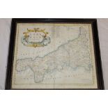
Keine Abbildung Los 339 DEVON. Speed, John. 339DEVON. Speed, John. Bearnes Hampton & Littlewood DEVON. Speed, John. Devonshire with Excester Described, an engraved county map, hand coloured, to be sold by Bassett & Chiswell (1676 edn.), in a ... Auf die Merkliste Live
Keine Abbildung Los 3568 Two early 19th century printed panels - a map of Ireland published 1812 by Laurie and Whittle and 3568Two early 19th century printed panels - a map of Ireland published 1812 by Laurie and Whittle and John Rolfe Auctions Two early 19th century printed panels - a map of Ireland published 1812 by Laurie and Whittle and a map of England and Wales, 55cm x 45cm Auf die Merkliste Live
Mindestpreis nicht eingehalten Keine Abbildung Los 102 MAGELLANICA - 17th CENTURY ENGRAVED MAP OF MAGELLAN STRAIT 102MAGELLANICA - 17th CENTURY ENGRAVED MAP OF MAGELLAN STRAIT Auctioneum Ltd - East Bristol & Bath A believed 17th century hand coloured engraved map of the hypothetical continent Magellanica. The map in Spanish, marked to lower right hand corne... Auf die Merkliste Timed
Keine Abbildung Los 839 'A New and Corrected Map of the Isle of Wight' by 839'A New and Corrected Map of the Isle of Wight' by HRD Auction Rooms Ltd 'A New and Corrected Map of the Isle of Wight' by G Brannon - framed and glazed Auf die Merkliste Live
Keine Abbildung Los 738 Robert Morden - a 17th century hand coloured map o 738Robert Morden - a 17th century hand coloured map o HRD Auction Rooms Ltd Robert Morden - a 17th century hand coloured map of Dorsetshire, together with Somerset Auf die Merkliste Live
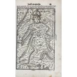
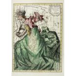
Keine Abbildung Los 918 ALLEGORICAL MAP -- (EUROPA REGINA, Queen Europe). (Basel, H. Petri, 1588). Plain allegorical 918ALLEGORICAL MAP -- (EUROPA REGINA, Queen Europe). (Basel, H. Petri, 1588). Plain allegorical Burgersdijk & Niermans ALLEGORICAL MAP -- (EUROPA REGINA, Queen Europe). (Basel, H. Petri, 1588). Plain allegorical woodcut map from S. Munster's 'Cosmographey', German ... Auf die Merkliste Live
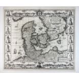
Keine Abbildung Los 936 DENMARK -- "DANIAE REGNI TYPUM". (Amst.), J. Janssonius, 1629. Plain engr. map incorporating 936DENMARK -- "DANIAE REGNI TYPUM". (Amst.), J. Janssonius, 1629. Plain engr. map incorporating Burgersdijk & Niermans DENMARK -- "DANIAE REGNI TYPUM". (Amst.), J. Janssonius, 1629. Plain engr. map incorporating 8 city views (incl. Copenhagen, Helsingør, Lubeck, an... Auf die Merkliste Live
Keine Abbildung Los 940 EASTERN EUROPE -- POLAND -- "ZAMOSCIUM, Nova Poloniæ civitas, (…)". (Cologne, Braun & Hogenberg, 161 940EASTERN EUROPE -- POLAND -- "ZAMOSCIUM, Nova Poloniæ civitas, (…)". (Cologne, Braun & Hogenberg, 161 Burgersdijk & Niermans EASTERN EUROPE -- POLAND -- "ZAMOSCIUM, Nova Poloniæ civitas, (…)". (Cologne, Braun & Hogenberg, 1617/18). Engr. view of Zamosc. 337 x 495 mm. (Ma... Auf die Merkliste Live
Keine Abbildung Los 856 C17th map of the West Riding of Yorkshire 856C17th map of the West Riding of Yorkshire Ryedale Auctioneers C17th map of the West Riding of Yorkshire Auf die Merkliste Live
Keine Abbildung Los 876 An unframed map of Northern India, Nepal and Pakistan, ' Magni Margolis ', Imperium, circa 1650 by 876An unframed map of Northern India, Nepal and Pakistan, ' Magni Margolis ', Imperium, circa 1650 by Lawrences of Bletchingley An unframed map of Northern India, Nepal and Pakistan, ' Magni Margolis ', Imperium, circa 1650 by Cornelius Blaeu, 48.5 x 57cm, including full m... Auf die Merkliste Live
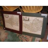
Keine Abbildung Los 525 ROBERT MORDEN: TWO HAND COLOURED ENGRAVED MAPS COMPRISING SOMERSETSHIRE AND GLOUCESTERSHIRE, 42 x 525ROBERT MORDEN: TWO HAND COLOURED ENGRAVED MAPS COMPRISING SOMERSETSHIRE AND GLOUCESTERSHIRE, 42 x JS Fine Art Auctioneers & Valuers ROBERT MORDEN: TWO HAND COLOURED ENGRAVED MAPS COMPRISING SOMERSETSHIRE AND GLOUCESTERSHIRE, 42 x 36cms and 41.5 x 34cms. (2) Auf die Merkliste Live
Keine Abbildung Los 919 ALLEGORICAL MAP -- "EUROPA Volgens de nieuwste Verdeeling". Haarlem, F. Bohn, (1794). Cont 919ALLEGORICAL MAP -- "EUROPA Volgens de nieuwste Verdeeling". Haarlem, F. Bohn, (1794). Cont Burgersdijk & Niermans ALLEGORICAL MAP -- "EUROPA Volgens de nieuwste Verdeeling". Haarlem, F. Bohn, (1794). Cont. handcold. allegorical engr. map. 237 x 167 mm. (Left b... Auf die Merkliste Live
Keine Abbildung Los 363 SPEED, John. 363SPEED, John. Bearnes Hampton & Littlewood SPEED, John. Devonshire with Excester Described, published by John Sudbury & George Humble 1623, hand coloured map, Exeter shown in an inset to on... Auf die Merkliste Live
Keine Abbildung Los 762 A WW2 Near East RAF / Special Forces silk escape map - printed double sided map K1/K2 Cyrenaica 762A WW2 Near East RAF / Special Forces silk escape map - printed double sided map K1/K2 Cyrenaica Tayler & Fletcher A WW2 Near East RAF / Special Forces silk escape map - printed double sided map K1/K2 Cyrenaica North Africa, scale 1:1,657,000, 47 x 54.5 cm. *... Auf die Merkliste Live
Keine Abbildung Los 1405 Very large National Geographic framed map of the world, 112cm x 78cm 1405Very large National Geographic framed map of the world, 112cm x 78cm John Rolfe Auctions Very large National Geographic framed map of the world, 112cm x 78cm Auf die Merkliste Live
Keine Abbildung Los 516 TWENTY-TWO VINTAGE MAPS, some cloth-backed, to include Ordnance Survey, Bartholomew's, R.A.F and 516TWENTY-TWO VINTAGE MAPS, some cloth-backed, to include Ordnance Survey, Bartholomew's, R.A.F and Richard Winterton Auctioneers TWENTY-TWO VINTAGE MAPS, some cloth-backed, to include Ordnance Survey, Bartholomew's, R.A.F and Duckham's Auf die Merkliste Live
Keine Abbildung Los 3100 A rare collection of WW2 Maps of the Tobruk together with canvas map case 3100A rare collection of WW2 Maps of the Tobruk together with canvas map case Hannam's Auctioneers A rare collection of WW2 Maps of the Tobruk together with canvas map case Auf die Merkliste Live
Keine Abbildung Los 549 A selection of Indian related engravings and maps including "Plan of the Cantonment of Ootacamund 549A selection of Indian related engravings and maps including "Plan of the Cantonment of Ootacamund Truro Auction Centre A selection of Indian related engravings and maps including "Plan of the Cantonment of Ootacamund 1841"; pen and ink sketch of a balcony scene; a ... Auf die Merkliste Live
Keine Abbildung Los 326 [ATLAS] COLE and ROPER. Nightingale, Joseph. 326[ATLAS] COLE and ROPER. Nightingale, Joseph. Bearnes Hampton & Littlewood [ATLAS] COLE and ROPER. Nightingale, Joseph. English Topography: or, a series of … Counties of England and Wales. Accompanied by a Map of each Cou... Auf die Merkliste Live
Keine Abbildung Los 363A SPEED, John. 363ASPEED, John. Bearnes Hampton & Littlewood SPEED, John. Kent, with her Cities and Earles described and observed, hand coloured map with inset plans of Rochester and Canterbury, English text... Auf die Merkliste Live
Keine Abbildung Los 854 C17th map of Saxton-Monmouth Monumethenis by Kip & Hole circa 1637, uncoloured and unframed, 39cm 854C17th map of Saxton-Monmouth Monumethenis by Kip & Hole circa 1637, uncoloured and unframed, 39cm Ryedale Auctioneers C17th map of Saxton-Monmouth Monumethenis by Kip & Hole circa 1637, uncoloured and unframed, 39cm x 32.5cm Auf die Merkliste Live
Keine Abbildung Los 184 Advertising - A Michelin tin wall sign depicting a map of the British Isles, approx 86cm x 63cm 184Advertising - A Michelin tin wall sign depicting a map of the British Isles, approx 86cm x 63cm Wessex Auction Rooms Advertising - A Michelin tin wall sign depicting a map of the British Isles, approx 86cm x 63cm Auf die Merkliste Live
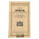
Mindestpreis nicht eingehalten Keine Abbildung Los 264 MAP OF INDIA WITH CEYLON, BURMA & BALUCHISTAN. IN CONTOUR COLOURING, SHOWING ROADS, AIRPORTS, ETC. 264MAP OF INDIA WITH CEYLON, BURMA & BALUCHISTAN. IN CONTOUR COLOURING, SHOWING ROADS, AIRPORTS, ETC. Olympia Auctions Timed SCALE 1 : 4,000,000 Map of India with Ceylon, Burma & Baluchistan. In Contour Colouring, showing roads, airports, etc. Scale 1 : 4,000,000 Barth... Auf die Merkliste Timed
Mindestpreis nicht eingehalten Keine Abbildung Los 73 *Local Interest - After Jones, Smith, & Co. (19th Century, British), coloured print, 'A New Map of 73*Local Interest - After Jones, Smith, & Co. (19th Century, British), coloured print, 'A New Map of 1818 Auctioneers *Local Interest - After Jones, Smith, & Co. (19th Century, British), coloured print, 'A New Map of the County of Cumberland divided into Wards', f... Auf die Merkliste Timed
Mindestpreis nicht eingehalten Keine Abbildung Los 521 BARTHOLOMEW, J.G. 521BARTHOLOMEW, J.G. Olympia Auctions Timed Constable's Hand Atlas of India Archibald Constable & Company Westminster 1893 Half morocco, gilt stamped cloth boards, top edge gilt. 117 pages o... Auf die Merkliste Timed
Mindestpreis nicht eingehalten Keine Abbildung Los 545 BARTHOLOMEW, J. 545BARTHOLOMEW, J. Olympia Auctions Timed Thackers Reduced Survey Map of India Thacker, Spink, & Co. Calcutta 1925 Pamphlet and map in boards. 62 page index. Large fold-out map. English Co... Auf die Merkliste Timed
Keine Abbildung Los 1681 John Norden (1546-1625), hand coloured map of Sussex, sold by John Sudbury and George Humble, text 1681John Norden (1546-1625), hand coloured map of Sussex, sold by John Sudbury and George Humble, text Gorringes John Norden (1546-1625), hand coloured map of Sussex, sold by John Sudbury and George Humble, text verso, 39 x 51cm Auf die Merkliste Live
Keine Abbildung Los 1794 John Speed (1552-1629) hand coloured map of Hertfordshire, sold by John Sudbury and George Humble, 1794John Speed (1552-1629) hand coloured map of Hertfordshire, sold by John Sudbury and George Humble, Gorringes John Speed (1552-1629) hand coloured map of Hertfordshire, sold by John Sudbury and George Humble, text verso, 40 x 53cm Auf die Merkliste Live
Keine Abbildung Los 555 Robert Morden - a 17th century hand coloured map o 555Robert Morden - a 17th century hand coloured map o HRD Auction Rooms Ltd Robert Morden - a 17th century hand coloured map of Gloucestershire, together with one of Cumberland Auf die Merkliste Live
Keine Abbildung Los 549 Robert Morden - a 17th century hand coloured map o 549Robert Morden - a 17th century hand coloured map o HRD Auction Rooms Ltd Robert Morden - a 17th century hand coloured map of Leicestershire, together with one other of the County of Lancaster Auf die Merkliste Live
Keine Abbildung Los 42 Map of the Coalfields of Scotland printed by W & A K Johnston, features Railways and Canals 42Map of the Coalfields of Scotland printed by W & A K Johnston, features Railways and Canals Lockdales Map of the Coalfields of Scotland printed by W & A K Johnston, features Railways and Canals Auf die Merkliste Live
Keine Abbildung Los 1794A 19th century hand coloured map of The Ancient Town of Rye after Percy F White, dated 1833, framed 1794A19th century hand coloured map of The Ancient Town of Rye after Percy F White, dated 1833, framed Eastbourne Auctions 19th century hand coloured map of The Ancient Town of Rye after Percy F White, dated 1833, framed and glazed, 27cm x 20cm excluding the frame Auf die Merkliste Live
Keine Abbildung Los 3176 CAREY, Henry Charles and Isaac LEA. The Geography, History and Statistics of America and the West 3176CAREY, Henry Charles and Isaac LEA. The Geography, History and Statistics of America and the West Toovey's CAREY, Henry Charles and Isaac LEA. The Geography, History and Statistics of America and the West Indies; Exhibiting a Correct Account of the Disc... Auf die Merkliste Live
Keine Abbildung Los 3219 BLACKIE, W.G. The Imperial Atlas of Modern Geography. London: Blackie and Son, 1860. Folio (373 x 3219BLACKIE, W.G. The Imperial Atlas of Modern Geography. London: Blackie and Son, 1860. Folio (373 x Toovey's BLACKIE, W.G. The Imperial Atlas of Modern Geography. London: Blackie and Son, 1860. Folio (373 x 310mm.) 100 maps hand-coloured in outline on 78 ... Auf die Merkliste Live
Keine Abbildung Los 1340 A COLLECTION OF LARGE SCALE ORDENANCE SURVEY AND OTHER MAPS. 1340A COLLECTION OF LARGE SCALE ORDENANCE SURVEY AND OTHER MAPS. JS Fine Art Auctioneers & Valuers A COLLECTION OF LARGE SCALE ORDENANCE SURVEY AND OTHER MAPS. Auf die Merkliste Live
Keine Abbildung Los 2117 A quantity of assorted 20thC Bartholomew road maps to include Cambridge, Dorset, New Forest, Sussex, 2117A quantity of assorted 20thC Bartholomew road maps to include Cambridge, Dorset, New Forest, Sussex, Claydon Auctioneers Ltd A quantity of assorted 20thC Bartholomew road maps to include Cambridge, Dorset, New Forest, Sussex, Warwickshire, Merseyside, Norfolk, English La... Auf die Merkliste Live
Keine Abbildung Los 2111 Map: An 18thC map of Gloucestershire with hand colouring, titled An Accurate Map of the Counties 2111Map: An 18thC map of Gloucestershire with hand colouring, titled An Accurate Map of the Counties Claydon Auctioneers Ltd Map: An 18thC map of Gloucestershire with hand colouring, titled An Accurate Map of the Counties of Gloucester and Monmouth Divided into their Res... Auf die Merkliste Live
Mindestpreis nicht eingehalten Keine Abbildung Los 97 Two David & Charles reprints of Ordnance Survey maps illustrating Kendal, & Lancaster & Blackpool, 97Two David & Charles reprints of Ordnance Survey maps illustrating Kendal, & Lancaster & Blackpool, 1818 Auctioneers Two David & Charles reprints of Ordnance Survey maps illustrating Kendal, & Lancaster & Blackpool, together with two others illustrating Lancaster... Auf die Merkliste Timed
Keine Abbildung Los 29 A 19th century black and white engraving of Porthleven Harbour with dedication and map for Messrs. 29A 19th century black and white engraving of Porthleven Harbour with dedication and map for Messrs. Truro Auction Centre A 19th century black and white engraving of Porthleven Harbour with dedication and map for Messrs. Harvey & Co. of Hayle and Porthleven Auf die Merkliste Live
Keine Abbildung Los 537 A 17th century hand coloured map of Cornwall by Robert Morden, 537A 17th century hand coloured map of Cornwall by Robert Morden, Truro Auction Centre A 17th century hand coloured map of Cornwall by Robert Morden, framed and glazed Auf die Merkliste Live
Keine Abbildung Los 204 A Kelly's Directory of Devon and Cornwall with maps 1926 and Kelly's Directory of Cornwall 1939 (20 204A Kelly's Directory of Devon and Cornwall with maps 1926 and Kelly's Directory of Cornwall 1939 (20 Truro Auction Centre A Kelly's Directory of Devon and Cornwall with maps 1926 and Kelly's Directory of Cornwall 1939 (20 Auf die Merkliste Live
Keine Abbildung Los 140 H.C CAREY AND I.LEA (publishers) A Complete Historical, Chronological and Geographical AMERICAN 140H.C CAREY AND I.LEA (publishers) A Complete Historical, Chronological and Geographical AMERICAN Adams H.C CAREY AND I.LEA (publishers) A Complete Historical, Chronological and Geographical AMERICAN ATLAS being a Guide to the History of NORTH and... Auf die Merkliste Live
Keine Abbildung Los 424 JOHN SPEED, BRITISH, 1552 - 1629, ENGRAVING WITH HAND COLOURING Titled ‘The Kingdome of England’ 424JOHN SPEED, BRITISH, 1552 - 1629, ENGRAVING WITH HAND COLOURING Titled ‘The Kingdome of England’ Swan Fine Art JOHN SPEED, BRITISH, 1552 - 1629, ENGRAVING WITH HAND COLOURING Titled ‘The Kingdome of England’ map, with drawn societal figures and detailed ca... Auf die Merkliste Live
Mindestpreis nicht eingehalten Keine Abbildung Los 248 Ancient Region of Palestine Charles Smith Classical 215 Antique Years Old Map. 248Ancient Region of Palestine Charles Smith Classical 215 Antique Years Old Map. William George Title: Ancient Region of Palestine Charles Smith Classical 215 Antique Years Old Map. Description: Ancient Region of Palestine Charles... Auf die Merkliste Timed
Keine Abbildung Los 934 CITY VIEWS / PLANS -- "PRAGA, BOHEMIAE METROPOLIS accuratissime expressa". (Cologne, Braun & Hogenbe 934CITY VIEWS / PLANS -- "PRAGA, BOHEMIAE METROPOLIS accuratissime expressa". (Cologne, Braun & Hogenbe Burgersdijk & Niermans CITY VIEWS / PLANS -- "PRAGA, BOHEMIAE METROPOLIS accuratissime expressa". (Cologne, Braun & Hogenberg, c. 1618). Handcold. engr. view of Prague (... Auf die Merkliste Live
Keine Abbildung Los 1035 SPAIN -- "HISPANIÆ, et Portugalliæ Maritimi tractus, à S. Andreo, ad Malagam/Pascaert 1035SPAIN -- "HISPANIÆ, et Portugalliæ Maritimi tractus, à S. Andreo, ad Malagam/Pascaert Burgersdijk & Niermans SPAIN -- "HISPANIÆ, et Portugalliæ Maritimi tractus, à S. Andreo, ad Malagam/Pascaert van Spangie, en Portugal". (Amst., L. Renard, 1715). Handcol... Auf die Merkliste Live
Keine Abbildung Los 933 CASPIAN SEA -- "NIEUWE CAART van de Caspische Zee, met alle desselfs riviere 933CASPIAN SEA -- "NIEUWE CAART van de Caspische Zee, met alle desselfs riviere Burgersdijk & Niermans CASPIAN SEA -- "NIEUWE CAART van de Caspische Zee, met alle desselfs riviere, eylanden en dieptens; na de laatste observatien gelegt en verbeeterd... Auf die Merkliste Live
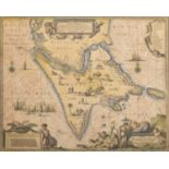
Keine Abbildung Los 926 ASIA -- INDIA -- "L'INDOSTAN: description de la partie des Indes Orientales qui est 926ASIA -- INDIA -- "L'INDOSTAN: description de la partie des Indes Orientales qui est Burgersdijk & Niermans ASIA -- INDIA -- "L'INDOSTAN: description de la partie des Indes Orientales qui est sous la domination du grand Mogol". (1660-1679). Plain engr. m... Auf die Merkliste Live


![[ATLAS] COLE and ROPER. Nightingale, Joseph.](https://portal-images.azureedge.net/auctions-2024/bearne10150/images/4bd431a9-b8cb-49bb-9b6a-b15000fc8b3f.jpg?w=155&h=155)