Sortieren nach:
- Kategorie
- Liste
- Galerie
Ein Abonnement der Preisliste ist notwendig um Ergebnisse, von Auktionen die vor einem längeren Zeitraum als 10 Tagen stattgefunden haben, ansehen zu können. Klicken Sie hier für mehr Informationen
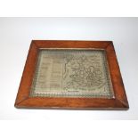

An attractive 19th century wool work picture entitled "A New Map of England and Wales", depicting
An attractive 19th century wool work picture entitled "A New Map of England and Wales", depicting England and Wales segregated into counties, with...
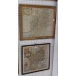
An 18th century coloured map of Gloucestershire by Robert Morden, 34 x 41 cm approx in moulded and
An 18th century coloured map of Gloucestershire by Robert Morden, 34 x 41 cm approx in moulded and fluted gilt frame together with a further colou...
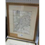
An 18th century map of Gloucestershire after Blomke inscribed Printed and Sold For Tho Taylor, 25
An 18th century map of Gloucestershire after Blomke inscribed Printed and Sold For Tho Taylor, 25 x 90 cm approx together with a 19th century map ...
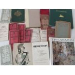
The Philips' Handy Atlas of the Counties of Ireland together with thirteen early 20th century
The Philips' Handy Atlas of the Counties of Ireland together with thirteen early 20th century Irish OS maps