Sortieren nach:
- Kategorie
- Liste
- Galerie
Ein Abonnement der Preisliste ist notwendig um Ergebnisse, von Auktionen die vor einem längeren Zeitraum als 10 Tagen stattgefunden haben, ansehen zu können. Klicken Sie hier für mehr Informationen
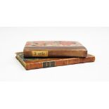

SMITH (C), SMITH'S NEW POCKET COMPANION TO THE ROADS OF ENGLAND AND WALES AND PART OF SCOTLAND,
SMITH (C), SMITH'S NEW POCKET COMPANION TO THE ROADS OF ENGLAND AND WALES AND PART OF SCOTLAND, 1st edition, 3/4 leather with marbled boards, gilt...
Four editions of PATTERSON (D), A NEW AND ACCURATE DESCRIPTION OF ALL THE DIRECT AND PRINCIPAL CROSS
Four editions of PATTERSON (D), A NEW AND ACCURATE DESCRIPTION OF ALL THE DIRECT AND PRINCIPAL CROSS ROADS IN GREAT BRITAIN, comprising: the 3rd E...

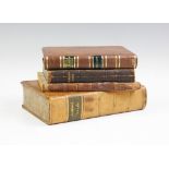
TAYLOR & SKINNER'S SURVEY OF THE ROADS OF SCOTLAND, later bound full leather, gilt title to spine,
TAYLOR & SKINNER'S SURVEY OF THE ROADS OF SCOTLAND, later bound full leather, gilt title to spine, engraved illustrated title page, lacks prefix m...
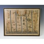
Two 17th century engraved and hand coloured maps, titled 'The Road From London to the City of
Two 17th century engraved and hand coloured maps, titled 'The Road From London to the City of Bristol', made by John Ogilby (1600-1676) and dated ...
A late 19th/early 20th century hand coloured map of Nottingham, originally drawn by John Speede,
A late 19th/early 20th century hand coloured map of Nottingham, originally drawn by John Speede, decorated in a variety of colours, framed and gla...
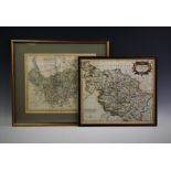
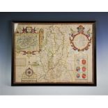
After Robert Morden (1650-1703), A map of 'The West Riding of Yorkshire', Hand coloured in a variety
After Robert Morden (1650-1703),A map of 'The West Riding of Yorkshire', Hand coloured in a variety of pigments, 37cm x 42cm, with a further map o...
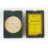
CARTOGRAPHIC INTEREST: Cary's Reduction Of His Large Map of England And Wales With Part Of Scotland,
CARTOGRAPHIC INTEREST: Cary's Reduction Of His Large Map of England And Wales With Part Of Scotland, published by J. Cary, 1834, in original cardb...