Sortieren nach:
- Kategorie
- Liste
- Galerie
Dieses Auktionshaus möchte seine Ergebnisse nicht veröffentlichen. Bitte kontaktieren Sie das Auktionshaus bei Fragen direkt.
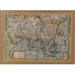

A map of Asia, titled Pariu Orbas Maxima M.D. XCVIII, dated 1608, designed by M.Quadt, printed and
A map of Asia, titled Pariu Orbas Maxima M.D. XCVIII, dated 1608, designed by M.Quadt, printed and hand-coloured, mounted and framed 40cm x 49cm P...
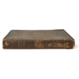
COLBY (C.) (ed.), ORDNANCE SURVEY OF THE COUNTRY OF LONDONDERRY, Vol. 1, Hodges & Smith, Dublin,
COLBY (C.) (ed.), ORDNANCE SURVEY OF THE COUNTRY OF LONDONDERRY, Vol. 1, Hodges & Smith, Dublin, 1837Please refer to department for condition repo...
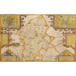
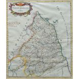
John Speed, British 1552-1629- Stafford Countie and Towne with the ancient Citie Lichfield described;hand-coloured engraving, rear panel indicates...
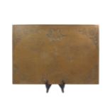
An engraved brass depiction of the Nova Totivs Terrarvm Orbis Geographica Ac Hydrographica Tabvla
An engraved brass depiction of the Nova Totivs Terrarvm Orbis Geographica Ac Hydrographica Tabvla map, in the baroque style, 20th century, origina...
Emanuel Bowen, British 1694-1767- Map of St Helena; hand-coloured engraving, 35.5 x 43 cm; Robert
Emanuel Bowen, British 1694-1767- Map of St Helena; hand-coloured engraving, 35.5 x 43 cm; Robert Morden, British 1650-1703- Map of Northumberland...