Sortieren nach:
- Kategorie
- Liste
- Galerie
Dieses Auktionshaus möchte seine Ergebnisse nicht veröffentlichen. Bitte kontaktieren Sie das Auktionshaus bei Fragen direkt.
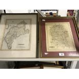

Maps: 19th cent. John Cary map of Wiltshire. 11ins. x 9ins. Plus R. Creighton map of Cumberland.
Maps: 19th cent. John Cary map of Wiltshire. 11ins. x 9ins. Plus R. Creighton map of Cumberland. 12ins. x 9½ins.
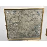
Maps: Original section of a 19th cent. Letts & Co. Map of Wiltshire showing Devizes and the outlying
Maps: Original section of a 19th cent. Letts & Co. Map of Wiltshire showing Devizes and the outlying area. Framed and glazed. 28ins. x 24ins. ......
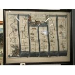
Maps: 17th cent. John Ogilby (1600-1676) 'The road from London to the Lands End, c1675. Hand
Maps: 17th cent. John Ogilby (1600-1676) 'The road from London to the Lands End, c1675. Hand coloured, engraved, strip map London to Winchester se...
Automobilia: Road maps 1930s, "The Motor Magazine Map of England, Wales & Southern Scotland".
Automobilia: Road maps 1930s, "The Motor Magazine Map of England, Wales & Southern Scotland". Eight plus maps 1-6 in original leather case. ...[m...
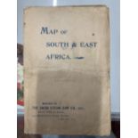
Maps/Maritime: Union Steam Ship Company map of South Africa c1898. 20ins. x 20ins. ...[more]