Sortieren nach:
- Kategorie,
- Künstler / Marke
- Liste
- Galerie
Ein Abonnement der Preisliste ist notwendig um Ergebnisse, von Auktionen die vor einem längeren Zeitraum als 10 Tagen stattgefunden haben, ansehen zu können. Klicken Sie hier für mehr Informationen

After Saxton. An early map of Lincoln in colours, 31cm x 36cm.
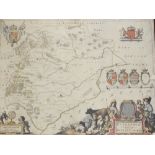
After Blome. An early map of Lincoln in colours, 34cm x 28cm.
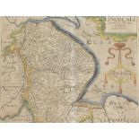
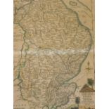
After Morden. An early map of Lincolnshire, in colours, 37cm x 45cm.
A facsimile map, showing parts of Lincolnshire and Rutland, 40cm x 51cm.
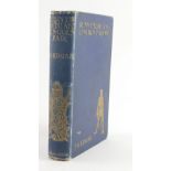
Edgar (J.G.), RUNNYMEDE AND LINCOLN FAIR... publisher's cloth, 8vo, (n.d.) c.1900.
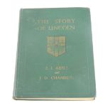
Abell (E.L.) and J.D. Chambers, THE STORY OF LINCOLN, publisher's cloth, small 4to, (n.d.) c.1947.
Abell (E.L.) and J.D. Chambers, THE STORY OF LINCOLN, publisher's cloth, small 4to, (n.d.) c.1947.
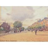
After W B Thomas. A framed postcard, Lumley Road, Skegness, 9cm x 14cm, after Thomas print and a fur
After W B Thomas. A framed postcard, Lumley Road, Skegness, 9cm x 14cm, after Thomas print and a further book plate print of Boston harbour. (3)
Fens.- AN ESSAY ON DRAINING...THE GREAT LEVEL OF THE FENS CALLED THE BEDFORD LEVEL, folding engraved
Fens.- AN ESSAY ON DRAINING...THE GREAT LEVEL OF THE FENS CALLED THE BEDFORD LEVEL, folding engraved map with loss at folds, contemporary half cal...
Fens.- THE REPORT OF THOMAS YEOMAN...CONCERNING THE DRAINAGE OF THE NORTH LEVEL OF THE FENS... 1769
Fens.- THE REPORT OF THOMAS YEOMAN...CONCERNING THE DRAINAGE OF THE NORTH LEVEL OF THE FENS... 1769 § .- THE REPORT OF JOHN SMEATON...CONCERNING ...
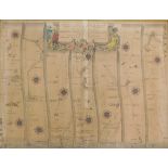
Fens.- ACTS OF PARLIAMENT RELATING TO THE DRAINAGE BY THE RIVER WITHAM... hand-coloured folding engr
Fens.- ACTS OF PARLIAMENT RELATING TO THE DRAINAGE BY THE RIVER WITHAM... hand-coloured folding engraved map, contemporary calf, rebacked, 8vo, Bo...
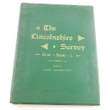
Greenstreet (James, ed.) THE LINCOLNSHIRE SURVEY, publisher's cloth, folio, 1884.
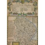
Maps, The Road from Nottingham to Grimsby, and another Bridgford, Shelford and Lincoln, 18cm x 13cm.
Maps, The Road from Nottingham to Grimsby, and another Bridgford, Shelford and Lincoln, 18cm x 13cm. (2)
After Ellis. Map of Lincolnshire in colours, print, 25cm x 20cm.
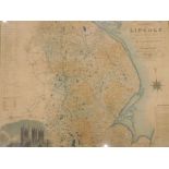
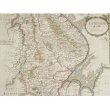
After Greenwood. Map of the county of Lincoln, from an actual survey in colours, print, 64cm x 83cm.
After Greenwood. Map of the county of Lincoln, from an actual survey in colours, print, 64cm x 83cm.
After Ogleby. Road from London to Boston in Lincolnshire map in colours, 34cm x 44cm, and a late pla
After Ogleby. Road from London to Boston in Lincolnshire map in colours, 34cm x 44cm, and a late plan of Boston from the 1836 original bookplate. ...
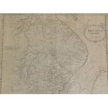
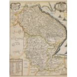
After Robert Morden. Map of Lincolnshire, 1690, 39cm x 45cm, framed and glazed.

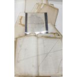
A collection of Lincolnshire maps, to include a framed Ordnance Survey map showing part of Lincolnsh
A collection of Lincolnshire maps, to include a framed Ordnance Survey map showing part of Lincolnshire with Boston centrally, and other unframed ...
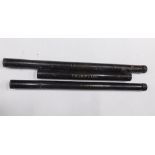
Three Lincolnshire related Ordnance Survey maps, each with mahogany rails and Tollware or painted ti
Three Lincolnshire related Ordnance Survey maps, each with mahogany rails and Tollware or painted tin cannister, for Leake, Frampton and Frieiston...
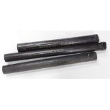
Three Lincolnshire related Ordnance Survey maps, each with a turned mahogany rail and a Tollware or
Three Lincolnshire related Ordnance Survey maps, each with a turned mahogany rail and a Tollware or painted tin cannister, for Stickney, Leverton ...
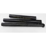
Three Lincolnshire related Ordnance Survey maps, each with a mahogany rail and a Tollware or painted
Three Lincolnshire related Ordnance Survey maps, each with a mahogany rail and a Tollware or painted tin cannister, for Skirbeck Quarter, Benningt...
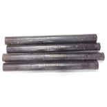
Three Lincolnshire related Ordnance Survey maps, each with a mahogany rail and a Tollware or painted
Three Lincolnshire related Ordnance Survey maps, each with a mahogany rail and a Tollware or painted tin cannister, for Butterwick, Wrangle and Wy...

A large quantity of Lincolnshire related folding Ordnance Survey maps, to include 2nd edition from 1
A large quantity of Lincolnshire related folding Ordnance Survey maps, to include 2nd edition from 1905 showing various areas to include Boston.
A quantity of 1905 edition and other Lincolnshire Ordnance Survey maps, mainly areas around Boston e
A quantity of 1905 edition and other Lincolnshire Ordnance Survey maps, mainly areas around Boston etc, unframed (AF).