Sortieren nach:
- Kategorie
- Liste
- Galerie
Ein Abonnement der Preisliste ist notwendig um Ergebnisse, von Auktionen die vor einem längeren Zeitraum als 10 Tagen stattgefunden haben, ansehen zu können. Klicken Sie hier für mehr Informationen
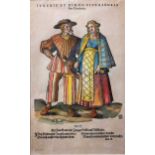

Jost Amman (1539-91) a group of four figural woodcuts from Trachtenbuch, circa 1577, the characters in elaborate costume, all with later hand colo...
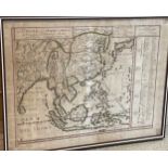
Pierre Duval, La Chine avec L'Empire du Mogol, les Presqu-Isles et les Isles de l'Asie, hand coloured engraved map circa 1684, 45 x 59cm (sheet), ...
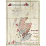
KNIPE (J A) Geological Map of Scotland, Lochs, Mountains, Islands, Rivers and Canals. The Railways
KNIPE (J A) Geological Map of Scotland, Lochs, Mountains, Islands, Rivers and Canals. The Railways and Principal Roads, and Sites of the Minerals,...
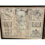
John Speed, Huntington Both Shire and Shire Towne with the Ancient Citie Ely Described, engraved map
John Speed, Huntington Both Shire and Shire Towne with the Ancient Citie Ely Described, engraved map of Huntingdonshire, for George Humble, circa ...
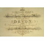
Devon. MUDGE (Lt. Col. William) The Second Part of the General Survey of England and Wales Containing the Whole of Devon and a Portion of the Adjo...
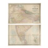
INDIA. STANFORD (Edward) Stanford's Map of India, based on the surveys executed by order of the
INDIA. STANFORD (Edward) Stanford's Map of India, based on the surveys executed by order of the Honourable The East India Company, 1857, in two se...
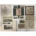
Engraved or etched county maps, to include Cheshire by P. Van Der Keere, North Wales by Badeslade
Engraved or etched county maps, to include Cheshire by P. Van Der Keere, North Wales by Badeslade and Toms, Dugdales’ Herefordshire etc. and a few...
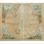
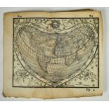
Johannes JanssoniusPolus Antarcticus, hand-coloured double-page engraved map of the South Polar
Johannes JanssoniusPolus Antarcticus, hand-coloured double-page engraved map of the South Polar region circa 1640, in a hemispherical projection w...
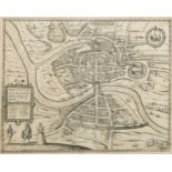
Bristol. BRAUN and HOGENBERG.Brightstowe, circa 1588, uncoloured engraved double page town plan,
Bristol. BRAUN and HOGENBERG.Brightstowe, circa 1588, uncoloured engraved double page town plan, 35 x 44cm ...[more]
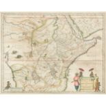
Jan Jansson. Aethiopia Superior vel Interior; vulgo Abissinorum sive Presbiteri Ioannis Imperium,
Jan Jansson. Aethiopia Superior vel Interior; vulgo Abissinorum sive Presbiteri Ioannis Imperium, engraved double page map with some hand colour, ...
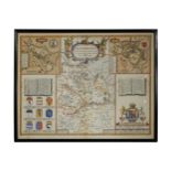
John Speed, Huntington Both Shire and Shire Towne with the Ancient Citie Ely Described, engraved
John Speed, Huntington Both Shire and Shire Towne with the Ancient Citie Ely Described, engraved hand coloured map of Huntingdonshire, for Bassett...
PROCLUS (Diadochus) De sphaera; CLEOMEDES, libri I & II; ARATI; DIONYSII; HONTERI; Basel: per
PROCLUS (Diadochus) De sphaera; CLEOMEDES, libri I & II; ARATI; DIONYSII; HONTERI; Basel: per Henricum Petri, 1561, small 8vo, circa 154 x 107mm, ...
WILLIAMS (H W) Select Views in Greece, London 1829, 4to, large paper, 64 mounted india plates,
WILLIAMS (H W) Select Views in Greece, London 1829, 4to, large paper, 64 mounted india plates, sporadic variable spotting or staining, main title ...
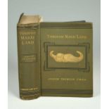
THOMSON (Joseph) Through Masai Land: A Journey of Exploration Among the Snowclad Volcanic Mountains and Strange Tribes of Eastern Equitorial Afric...