Sortieren nach:
- Kategorie
- Liste
- Galerie
Ein Abonnement der Preisliste ist notwendig um Ergebnisse, von Auktionen die vor einem längeren Zeitraum als 10 Tagen stattgefunden haben, ansehen zu können. Klicken Sie hier für mehr Informationen
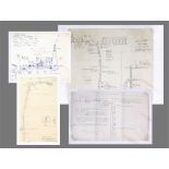

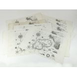
LEVANT MINE.
LEVANT MINE. A detailed pencil drawing/plan by P G Laws of Levant Mine, dated 1971. 42 x 51cm. Also, another pencil drawing of Levant Mine Man Eng...
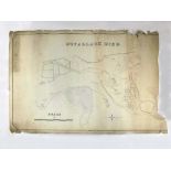
BOTALLACK MINE.
BOTALLACK MINE. A 19th century hand drawn & coloured map of Botallack Mine workings. 57 x 75cm. Please note that all items in this auction are pr...
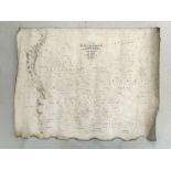
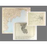
PLAN OF ST. JUST.
PLAN OF ST. JUST. A 19th century plan of the tenements of Roscommon, Carnyorth, Botallack & Carrallack in the Parish of St. Just. Laid down onto l...
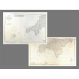
ORDNANCE SURVEY MAP.
ORDNANCE SURVEY MAP. An Ordnance Survey Map of Trethosa Downs showing extensive mining activities. This map is the 1932 revision, printed at the O...
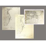
PENZANCE MAP ETC.
PENZANCE MAP ETC. An Ordnance Survey Map of Penzance Harbour & its surroundings, showing many buildings & numerous courts that have disappeared or...
ORDNANCE SURVEY MAPS.
ORDNANCE SURVEY MAPS. An Ordnance Survey map of the Truro area, Revision dated 1933. 57 x 42cm. Also, two other maps, one of Penzance dated 1982, ...
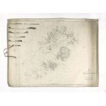
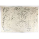
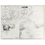
ISLES OF SCILLY CHART.
ISLES OF SCILLY CHART. An 1866 sea chart of the Isles of Scilly. 69 x 100cm. Note: All maps & charts in this auction have age & are in used condit...
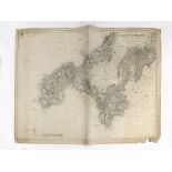
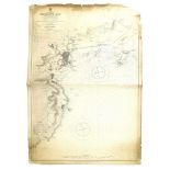
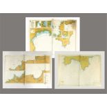
CORNWALL SEA CHART.
CORNWALL SEA CHART. An 1891 sea chart of St. Agnes Head to Gerrans Bay. 68 x 100cm. Note: All maps & charts in this auction have age & are in used...
CORNWALL SEA CHART.
CORNWALL SEA CHART. A sea chart of the Helford River. 54 x 70cm. Possibly a facsimile? Note: All maps & charts in this auction have age & are in u...
CORNWALL SEA CHART.
CORNWALL SEA CHART. A 1931 sea chart of Penzance Bay. 70 x 100cm. Note: All maps & charts in this auction have age & are in used condition so have...
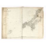
CORNWALL SEA CHART.
CORNWALL SEA CHART. A sea chart of Trevose Head to Dodman Point. 70 x 100cm. Note: All maps & charts in this auction have age & are in used condit...
SHIPWRECK CHARTS.
SHIPWRECK CHARTS. A copy of hand-drawn 1797 sea chart, showing several shipwrecks in the Mounts Bay area, a chart of the Manacles Reef in Falmouth...
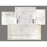
SHIPBUILDERS PLANS.
SHIPBUILDERS PLANS. A shipbuilder's drawing of the 'Nepaul' & copies of the original shipbuilders plans for a Devon sailing lighter & a Cherokee c...
CORNWALL SEA CHARTS.
CORNWALL SEA CHARTS. Two sea charts: Trevose Head to Dodman Point with the Isle of Scilly & Trevose Head to Dodman Point. Note: All maps & charts ...
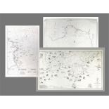
DEPTH CHARTS.
DEPTH CHARTS. Three depth charts for the West Cornwall coast: Land's End to Falmouth; North Coast & Harbours & South Coast & Harbours. Note: All m...
MAP PRINTS.
MAP PRINTS. Ten printed copies of a fantasy map created & drawn by Roland Morris 'A Mapp of the Cornish Island of W. Penwith'. Unframed. Provenanc...