Sortieren nach:
- Kategorie
4 items
- Liste
- Galerie
Ein Abonnement der Preisliste ist notwendig um Ergebnisse, von Auktionen die vor einem längeren Zeitraum als 10 Tagen stattgefunden haben, ansehen zu können. Klicken Sie hier für mehr Informationen
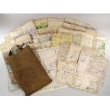

Los 188
FLIGHT MAPS ETC.
FLIGHT MAPS ETC.A map bag named Cromby, containing 17 various air ministry maps for Berlin, Casablanca, Straits of Dover. Also two Canadian Depart...
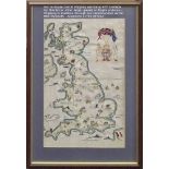
Los 220
EMBROIDERED MAP.
EMBROIDERED MAP.An early 20th century embroidered map of the British Isles, showing the coast of France with naval shipping in the channel. 63 x 4...
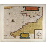
Los 223
ANTIQUE MAP.
ANTIQUE MAP. A hand coloured map of Cornwall & the Isles of Scilly by Theunisz Jacobsz. Image size 43 x 53cm.
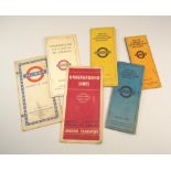
Los 388
UNDERGROUND MAPS.
UNDERGROUND MAPS. Six London Underground pocket maps. 1926, 1927, 1939, 1951 & two undated.