Sortieren nach:
- Kategorie
- Liste
- Galerie
Ein Abonnement der Preisliste ist notwendig um Ergebnisse, von Auktionen die vor einem längeren Zeitraum als 10 Tagen stattgefunden haben, ansehen zu können. Klicken Sie hier für mehr Informationen

Cartography - a 19th century Ordnance Survey map, Hawes (Kirkby Stephen), Sheet 50 (formerly 97 SW),
Cartography - a 19th century Ordnance Survey map, Hawes (Kirkby Stephen), Sheet 50 (formerly 97 SW), printed from electrotype taken in 1886, railw...
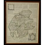
Emanuel Bowen and Thomas Kitchin, an engraved and coloured map, A New Map of the Counties of
Emanuel Bowen and Thomas Kitchin, an engraved and coloured map, A New Map of the Counties of Cumberland and Westmoreland Divided into their Respec...
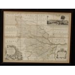
Emmanuel Bowen, an engraved map, An Accurate Map of the West Riding of Yorkshire divided into
Emmanuel Bowen, an engraved map, An Accurate Map of the West Riding of Yorkshire divided into Wapontakes, published by Robert Sayers & John Bennet...
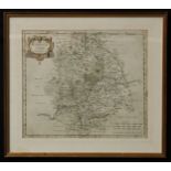
Robert Morden, an engraved and coloured two-page map, Warwickshire, sold by Abel Swale, Awnsham &
Robert Morden, an engraved and coloured two-page map, Warwickshire, sold by Abel Swale, Awnsham & John Churchill, 37cm x 43cm ...[more]

A George III needlework map sampler, England, the counties marked out and annotated, with Dublin,
A George III needlework map sampler, England, the counties marked out and annotated, with Dublin, Ireland, the Irish Sea, Scotland, The Holy Isles...