Sortieren nach:
- Kategorie
2 items
- Liste
- Galerie
Ein Abonnement der Preisliste ist notwendig um Ergebnisse, von Auktionen die vor einem längeren Zeitraum als 10 Tagen stattgefunden haben, ansehen zu können. Klicken Sie hier für mehr Informationen
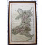

Cary (John) A New Map of the Principality of Wales, Divided into Counties, 1809, 98.5 x 59.5cm (plate size), framed and glazed
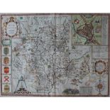
Los 323
A map of Worcestershire, described by Christopher Saxton, augmented and published by John Speede,
323A map of Worcestershire, described by Christopher Saxton, augmented and published by John Speede,
A map of Worcestershire, described by Christopher Saxton, augmented and published by John Speede, John Sudbury and George Humble, later hand colou...