Collectables Auctions

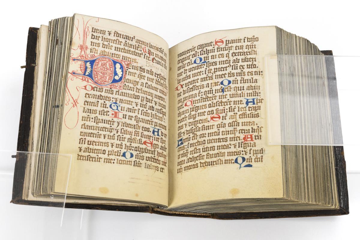
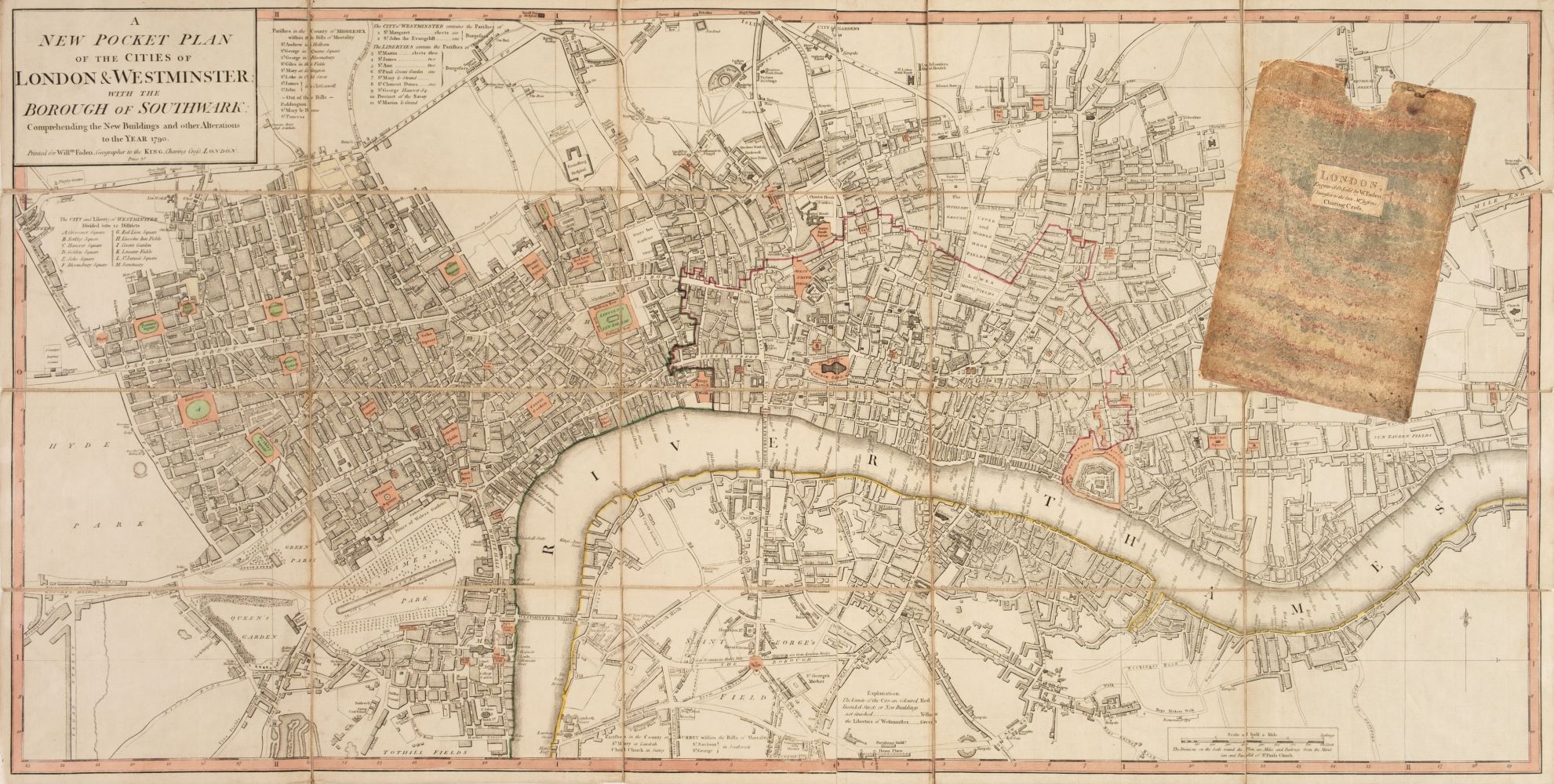
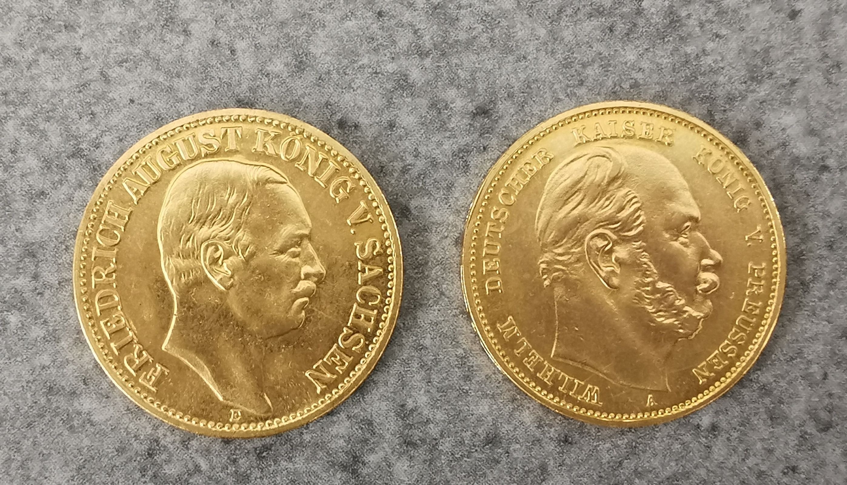
Explore an enormous array of collectables auctions on the UK's leading online auction marketplace. Browse models, toys, dolls, games, arms, armour, militaria, books & periodicals, sporting equipment & memorabilia, musical instruments, stamps, coins, classic cars & motorcycles, camera & camera equipment, wines & spirits, maps, religious items & folk art, banknotes, entertainment memorabilia, and more. With so many reputable auction houses selling on the saleroom, you can find the collectables auctions you're looking for and more. Use tools like watch lists, auction alerts, filters, and more to speed up your search and compete in live and timed auctions. Place winning bids on the items that match your criteria and get your next collectable on the saleroom.

À VENIR Enchère

Gorringes Weekly featuring Textiles - Monday 10th June 2024
gavel Gorringes
room Lewes, East Sussex
View auction
Sale of Vintage Toys and Models
room Runcorn, Cheshire
View auction
The Monday Sale - Saleroom 3 & 4
Weekly Auction of modern Furniture, Collectables, Household Effects, etc (Saleroom 6)
TIMED Autograph auction Football, Space, TV/Film, Military, Historic photos, covers and books.
Antiques, Interiors & Collectables
953 item(s)

Affinez votre recherche

Photographies

Estimation

Filter by Price Range

Localisation géographique

Catégorie

  • Maps (953)
Supprimer le filtre

Creator / Brand

Item Type

Type

Pays

Salle des Ventes

Filtered by:

  • Catégorie
  • Liste
  • Grille
  • 953 item(s)
    /page

Massief zilveren troffee 'Drag Hunt Steeplechase Alag, 1902 November 8' geschonken aan 'A Masodik Lo Lovasanak', in de vorm van een schaal met bas...

Handcol. engr., 47 x 57 cm, depicting an armillary sphere, a celestial globe and a terrestrial globe, Nuremburg, J.B. Homann, ca. 1720, framed und...

Du déjeuner Pullman au diner. Paris-Bruxelles-Amsterdam. Paris, Hachard & Cie, 1927. 106 x 75 cm. Corners and minor dam. to folds, professionally ...

Title: Pre-War London Postal Districts and Sub-Districts Coloured Detailed Map-184. Description: Pre-War London Postal Districts and S...

Spanish 'piece of eight' 8 reale coin, recovered from the site of the wreck of HMS Association on Gilstone Ledges, Isles of Scilly

SPEED (JOHN) The Kingdome of China Newly Augmented by I.S. 1626, hand-coloured engraved map, decorated borders with eight costumed figures in ve...

Historical map set from 1839-1866 in box Historical map set in original box from 1839, maps hinged with gray cloth binding. Beautiful condition, ...

India. Wyld (James), Map of India, Constructed with Great Care and Research from All the Latest Authorities, and Intended more particularly to Fa...

Lot 337

Speed, John

Speed, John The Invasions of England and Ireland with al [sic] their Civill Wars since the Conquest Performed by John Speed and are to be solde ...

A WWII Second World War British ' escape ' silk map of Eastern Europe & Greece sheets 43 H and G. Scale 1;100,000. Folds to pocket handkerchief si...

A 17th century hand-coloured and engraved map of Northumberland by Robert Morden, 43cm x 36cm, together with a further Robert Morden map of the Bi...

AFRICA BLAEU (WILLEM) Africae nova descriptio, hand-coloured engraved double-page map, 10 costumed figures on the vertical margins and 9 oval vi...

Globes. Philip's British Empire Globe. London: George Phillip & Son, circa 1930, 8 inch table globe with twelve colour lithographic gores, oval ...

World. Imperial Federation - Map of the World showing the extent of the British Empire in 1886. Statistical Information published by Captain J. C...

* British Isles. Speed (John), The Kingdome of Great Britaine and Ireland, John Sudbury & George Humble, circa 1627, hand-coloured engraved m...

SOCIETY FOR THE DIFFUSION OF USEFUL KNOWLEDGE The Complete Atlas of Modern, Classical and Celestial Maps, together with Plans of the Principal Cit...

An early 17th-century Dutch hand-coloured and engraved map of Northumberland, Cumbria and Durham, published Amsterdam 1607, 14cm x 19cm, together ...

A GEORGE III MAP SAMPLER, 1786, worked in coloured silks on a loosely woven ground with a map of England and Wales by Sarah Rushton of Macc(lesfie...

JOHN SPEED. Engraved map of the Isle of Wight, sold by Thomas Basket in Fleet Street and Richard Chiswell in St Paul's Churchyard, hand coloured, ...

World. Speed (John), A New and Accurat Map of the World. Drawne according to ye truest Descriptions, latest Discoveries & best Observations y't h...

NORFOLK and SUFFOLK SPEED (JOHN) Norfolk, a Countie Florishing & Populous Described and Devided with the Armes of such Noble Familes as have Borne...

Edward Stanford, City of Victoria Vancouver Island water-colour tinted engraved map, dissected and laid of cotton, cloth covered boards with prin...

1970s London Underground map poster

AFRICA DE WIT (FREDERICK) Totius Africae Accuratissima Tabula, hand-coloured double-page engraved map, decorative title cartouche, animal vignet...

EAST AFRICA DE WIT (FREDERICK) Occidentalior Tractus Indiarum Orientalium a Promontorio Bonae Spei ad C. Comorin, hand-coloured engraved double-...

London. Gill (MacDonald), Wonderground Map of London Town, published by The Westminster Press, circa 1928, colour photolithographic map, old fol...

Heylyn (Peter). Cosmographie, in four Books. Containing the Chorography and History of the Whole World: and all the Principal Kingdoms, Province...

AR London. Newcourt (Richard & William Faithorne), An Exact Delineation of the Cities of London and Westminster and the Suburbs Thereof, toge...

Lot 334

Speed, John

Speed, John Cambridgeshire described with the devision of the hundreds, The Townes situation, with the Armes of the Colleges Of that famous Univ...

SPEED (JOHN) Yorkshire; The North and East Ridings of Yorkshire, inset plans of Hull and Richmond ; The West Ridinge of Yorkeshyre with Most Fam...

AFRICA MUNSTER (SEBASTIAN) Africa Lybia Morenlandt mit allen königreichen so zu unsern zeiten darin gefunden werden, hand-coloured woodcut map, ...

AFRICA HONDIUS (HENRICUS) Africae nova Tabula, double-page hand-coloured engraved map, numerous ships, sea-monsters, animals (elephants, lions, ...

THAILAND and EAST ASIA TACHARD (GUY) Reis Na Siam edaan door den Ridder de Chaumont, in't Nederduitsch gebracht door G. V. Broekhuizen, addition...

United States. Melish (John). Map of the United States with the contiguous British & Spanish Possessions Compiled from the latest & best Authori...

* British Isles. Speed (John), The Invasions of England and Ireland with al their Civill Wars since the Conquest, George Humble, circa 1627, ...

2 SA Soldaten mit Hund Lineol und Elastolin, 7,5-cm-Serie, SA, Lineol Fahnenträger ohne Fahne; Lineol Maschierer; Elastolin Sanitäts-Hund; min. A...

A collection of seven 20th century Conic Projection maps together with another. The lot to include: the map of Iran (Persia) scale 1:4,000,000 pla...

Warwickshire, three antique framed maps of Warwickshire, including; Bowen & Owen Warwickshire, Warwickshire by Christopher Saxton from Camden’s Br...

JOHN SPEED. Engraved map of Herefordshire; an engraved map by John Speed titled 'Worcestershire Described' and a further map by John Speed titled ...

Collection of unframed early 20th century and later folding OS maps and part maps, to include John Cary (British 1754-1835): 'Cary's Map of the Co...

WEST AFRICA DE WIT (FREDERICK) Tractus Littorales Guineae a Promontorio Verde usque ad Sinum Catenbelae, hand-coloured engraved double-page map,...

[CHATELAIN (HENRY ABRAHAM)] Atlas historique, ou nouvelle introduction a l'histoire..., vol. 6 (with Africa section only), title printed in red ...

A LARGE SPANISH 'CUENCA' GALLERY CARPET Approximately 844 x 154cm Provenance: From a Private Collection, Berkshire, gathere...

A charming George III silk work map of England and Wales, by Elizabeth Honeley 1784, stitched on linen, approx 40.5 x 49 cms, framed and glazed.

A 1840 paper on linen map of The British Isles, printed by J & C Walker, London, showing the cities, boroughs & market towns, the principal villag...

Bacon (G. W., publisher). Bacon's Large Scale Atlas of London and Suburbs (Revised Edition) with an Alphabetical Index, circa 1910, title page a...

British Isles. Overton (Henry). A New and Exact Mapp of Great Britain and Ireland According to the Latest and Best Observations, 1716, large eng...

British County Maps. A collection of approximately 200 maps, mostly 18th & 19th-century, county, country and regional maps, city plans and road ...

World. Navy League Map of the British Empire, published by The London Geographical Institute, circa 1925, a very large colour-printed wall map, ...

* British County Maps. A collection of approximately 65 maps, 17th - 19th century, engraved county and regional maps and city plans, includin...

* England & Wales. Speed (John), The Kingdome of England, Thomas Bassett & Richard Chiswell [1676], hand-coloured 'carte-a-figures' map engra...

SPEED (JOHN) AND WILLEM BLAEU Pictorial title-pages to Speed's 'Theatre of the Empire of Great Britain', 1650, and Blaeu's 'Le Théâtre du Monde......

Railwayana - a collection of assorted Railway maps and posters comprising; Alan Young illustrated railway map of the South West, Great Orme Tramwa...

A collection of approximately x80 RAF Royal Air Force and wartime OS maps comprising x20 RAF maps from the 1939-45 period including maps of Englan...

WW2 British Escape and Evasion Silk Map Sheet 43E / 43F. Double sided in colour covering Germany and central Europe on one side and Croatia and th...

A group of bathymetrical surveys of the Freshwater Lochs of Scotland, published by the Royal Geographical Society. (1 box)

Loading...Loading...

Recently Viewed Lots