Refine your search
Filtered by:
- Sale Section
- List
- Grid
A subscription to the Price Guide is required to view results for auctions ten days or older. Click here for more information


A late 18c needlework numerical and alphabetical sampler , with verse, A Summer Evening by Elizabeth
A late 18c needlework numerical and alphabetical sampler , with verse, A Summer Evening by Elizabeth Busnell of Stourton Mill, Aged 14 years, 1791...
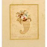
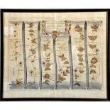
A late 18c/early 19c silkwork on paper picture of a cornucopia of flowers, accompanied by script '
A late 18c/early 19c silkwork on paper picture of a cornucopia of flowers, accompanied by script 'Needlework done with the mouth by Martha Honeywe...

A 19c silkwork picture of a lady seated outside a cottage spinning, oval framed and glazed, 7.5" x
A 19c silkwork picture of a lady seated outside a cottage spinning, oval framed and glazed, 7.5" x 5.5".
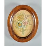
A Victorian oval silkwork picture of a bouquet of flowers, oval framed and glazed, 6.5" x 5".
A Victorian oval silkwork picture of a bouquet of flowers, oval framed and glazed, 6.5" x 5".
A Victorian silkwork tapestry of a young girl kneeling and praying, signed M Mirrlees, framed and
A Victorian silkwork tapestry of a young girl kneeling and praying, signed M Mirrlees, framed and glazed, 16.5" x 13".
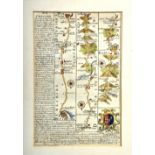
Three 18c road maps, framed and glazed, comprising Senex Road Maps 1719-1775, a double sided from
Three 18c road maps, framed and glazed, comprising Senex Road Maps 1719-1775, a double sided from the 1762 atlas, the road from Chester to Cardiff...
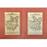
A collection of three antique maps including a John Sellai map of Caernarvonshire 4.5" x 5.75", a
A collection of three antique maps including a John Sellai map of Caernarvonshire 4.5" x 5.75", a Badeslade & Toms map of north Wales circa 1742 6...
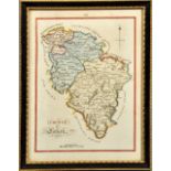
A late 18c map of the county of Lanark, framed and glazed, 7" x 5.25".
An 18c Rigobert Bonne map of Carte du Canal du Mosambique, the Isle of Madagascar with the Cotes d'
An 18c Rigobert Bonne map of Carte du Canal du Mosambique, the Isle of Madagascar with the Cotes d'Afrique, framed and glazed, 8" x 12".
A John Ogilby road map of Chester to Cardiff and from Chester to Wrexham, circa 1675-1698 and
A John Ogilby road map of Chester to Cardiff and from Chester to Wrexham, circa 1675-1698 and being a first edition, with no printed map number, f...
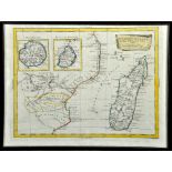
An Antonio Zatta antique map of the isle of Madagascar, Borbon, Francia with the coast of Africa,
An Antonio Zatta antique map of the isle of Madagascar, Borbon, Francia with the coast of Africa, Venezia 1784, framed and glazed, 12" x 16".
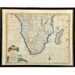
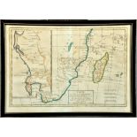
An Emanuel Bowen new and accurate map of the southern parts of Africa, circa 1750, framed and
An Emanuel Bowen new and accurate map of the southern parts of Africa, circa 1750, framed and glazed, 13" x 16.5".
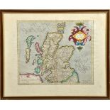
A late 16c Geradus Mercator coloured map of Scotia Regnum, with printed rear, being pages 56 and 57,
A late 16c Geradus Mercator coloured map of Scotia Regnum, with printed rear, being pages 56 and 57, framed and glazed, 13.5" x 15.5".
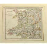
A 19c Chapman Hall edition of a map of Wales and Anglesey, titled England II and published under the
A 19c Chapman Hall edition of a map of Wales and Anglesey, titled England II and published under the superintendance of the Society for the Diffus...
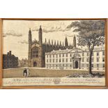
P S Lamborn - a view of Kings College and part of Clare Hall in the University of Cambridge, a
P S Lamborn - a view of Kings College and part of Clare Hall in the University of Cambridge, a printed linen in black and white, framed and glazed...