
Refine your search
Sale Section
Remove filterEstimate
Category
- Maps (645)
- Books & Periodicals (111)
- Prints (25)
- Arms, Armour & Militaria (6)
- Models, Toys, Dolls & Games (3)
- Bank notes (1)
- Chinese Works of Art (1)
- Collectables (1)
- Drawings & Pastels (1)
- Furniture (1)
- Greek, Roman, Egyptian & Other Antiquities (1)
- Japanese Works of Art (1)
- Scientific Instruments (1)
- Taxidermy & Natural History (1)
- Textiles (1)
Filtered by:
- Sale Section
- List
- Grid
A subscription to the Price Guide is required to view results for auctions ten days or older. Click here for more information

Sebastian Munster 1552 La Cosmographie Universelle Recueillie de Chasque bon Autheur & Approue, tant
Sebastian Munster 1552 La Cosmographie Universelle Recueillie de Chasque bon Autheur & Approue, tant des Historiens... This title page contains an...
Galle/Stradanus 1592 Americae Retectio This fascinating allegorical engraving commemorates the
Galle/Stradanus 1592 Americae Retectio This fascinating allegorical engraving commemorates the discovery of the New World. Flora (Florence) and J...
Mercator/Hondius 1619 Germaniae Tabule Geographicae Lovely frontispiece in the Dutch Renaissance
Mercator/Hondius 1619 Germaniae Tabule Geographicae Lovely frontispiece in the Dutch Renaissance style with the title surrounded with strapwork de...
Mercator/Hondius 1619 Italiae, Sclavoniae, et Graeciae Tabule Geographice This handsome sheet introduced the section of Mercator's famous Atlas th...
Blaeu Family 1640 Theatrum Orbis Terrarum, sive Atlas Novus Tertia Pars cum Appendice I & II Partium
Blaeu Family 1640 Theatrum Orbis Terrarum, sive Atlas Novus Tertia Pars cum Appendice I & II Partium Antehac Editarum This is a superb architectur...
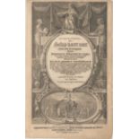
Van Linschoten 1644 Itinerarium, ofte Schip-Vaert naer Oost ofte Portugaels Indien... This is the
Van Linschoten 1644 Itinerarium, ofte Schip-Vaert naer Oost ofte Portugaels Indien... This is the title page to the last Dutch edition of Linschot...

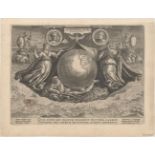
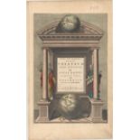
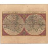
Henry Abraham Chatelain 1721 Atlas Historique. Tome Premier The frontispiece, by B. Picart, shows
Henry Abraham Chatelain 1721 Atlas Historique. Tome Premier The frontispiece, by B. Picart, shows classical muses representing: Geography, using m...
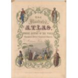
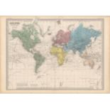
John Tallis 1851 The Illustrated Atlas, and Modern History of the World Geographical, Political,
John Tallis 1851 The Illustrated Atlas, and Modern History of the World Geographical, Political, Commercial & Statistical… A lovely steel engraved...
![Bordone 1528 [Untitled - World] This is one of the earliest world maps drawn on an oval](https://portal-images.azureedge.net/auctions-2016/srol10009/images/6c695d68-27dd-4446-8449-b67ff48015c1.jpg?w=155&h=155)
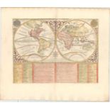
Bordone 1528 [Untitled - World] This is one of the earliest world maps drawn on an oval projection, preceded only by that of Francesco Rosselli's ...
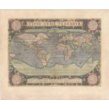
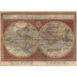
Abraham Ortelius 1587 Typus Orbis Terrarum Ortelius' beautiful oval world map is a simplified
Abraham Ortelius 1587 Typus Orbis Terrarum Ortelius' beautiful oval world map is a simplified version of Mercator's influential map of 1569. From...
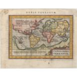
Rumold Mercator 1587 Orbis Terrae Compendiosa Descriptio quam ex Magna Universali Gerardi Mercatoris
Rumold Mercator 1587 Orbis Terrae Compendiosa Descriptio quam ex Magna Universali Gerardi Mercatoris Domino Richardo Gartho... An elaborate strapw...
Ortelius/Coignet 1601 Typus Orbis Terrarum This is the first miniature world map presented on
Ortelius/Coignet 1601 Typus Orbis Terrarum This is the first miniature world map presented on Mercator's projection. It depicts the large souther...
Hondius/Bertius 1616 Typus Orbis Terrarum Charming miniature world map on an oval projection,
Hondius/Bertius 1616 Typus Orbis Terrarum Charming miniature world map on an oval projection, based on Ortelius. The large, mythical continent of...
Abraham Goos 1617 Orbis Terrae Compendiosa Descriptio ex ea, quam ex Magna Universali Mercatoris
Abraham Goos 1617 Orbis Terrae Compendiosa Descriptio ex ea, quam ex Magna Universali Mercatoris Rumoldus Mercator... Goos engraved this small dou...
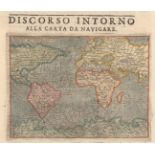
Tomaso Porcacchi 1620 Discorso Intorno alla Carta da Navigare This nautical world map, engraved by
Tomaso Porcacchi 1620 Discorso Intorno alla Carta da Navigare This nautical world map, engraved by Girolamo Porro, was one of two world maps inclu...
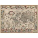
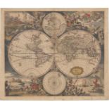
Willem Blaeu 1635 Nova Totius Terrarum Orbis Geographica ac Hydrographica Tabula A magnificent map
Willem Blaeu 1635 Nova Totius Terrarum Orbis Geographica ac Hydrographica Tabula A magnificent map featuring a carte-a-figures border with allegor...
Robert Walton 1659 A New and Accurat Map of the World Drawne According to ye Truest Descriptions
Robert Walton 1659 A New and Accurat Map of the World Drawne According to ye Truest Descriptions Latest Discoveries & Best Observations yt Have Be...
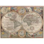
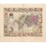
Johannes Blaeu 1660 Nova et Accuratissima Totius Terrarum Orbis Tabula This splendid world map is
Johannes Blaeu 1660 Nova et Accuratissima Totius Terrarum Orbis Tabula This splendid world map is one of the most elegantly engraved maps from the...
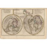
Richard Blome 1678 Geography This interesting illustration of the science of geography centers on
Richard Blome 1678 Geography This interesting illustration of the science of geography centers on a simple double hemisphere world map depicting C...
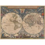
Moses Pitt 1680 Nova Totius Terrarum Orbis Geographica ac Hydrographica Tabula This beautiful map is
Moses Pitt 1680 Nova Totius Terrarum Orbis Geographica ac Hydrographica Tabula This beautiful map is one of the most intriguing examples of the in...
Justus Danckerts 1680 Nova Totius Terrarum Orbis Tabula This is Danckerts' version of De Wit's
Justus Danckerts 1680 Nova Totius Terrarum Orbis Tabula This is Danckerts' version of De Wit's splendid maritime world map. The cartographic feat...
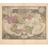
Blaeu/Valck 1695 Novus Planiglobii Terrestris per Utrumque Polum Conspectus This uncommon, beautifully engraved map showing the world on a polar p...
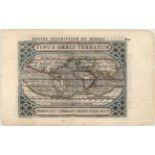
Lasor a Varea 1713 Orbis Terrae Compendiosa Descriptio A finely engraved double hemisphere map based
Lasor a Varea 1713 Orbis Terrae Compendiosa Descriptio A finely engraved double hemisphere map based on Rumold Mercator's great map of 1587. It i...
Lasor a Varea 1713 Universi Orbis Descriptio ad Usum Navigantum This small mariner's map is based on
Lasor a Varea 1713 Universi Orbis Descriptio ad Usum Navigantum This small mariner's map is based on one of the most important world maps of the 1...
Lasor a Varea 1713 Universi Orbis Descriptio Girolama Porro originally engraved this map for Giovanni Magini's quarto edition of Ptolemy's Geograp...
Henry Abraham Chatelain 1720 Mappe-Monde pour Connoitre les Progres & les Conquestes les Plus
Henry Abraham Chatelain 1720 Mappe-Monde pour Connoitre les Progres & les Conquestes les Plus Remarquables des Provinces-Unies... The voyages and ...
Henry Abraham Chatelain 1720 Plan de l'Histoire Universelle, ou l'on voit les Quatre Monarchies du
Henry Abraham Chatelain 1720 Plan de l'Histoire Universelle, ou l'on voit les Quatre Monarchies du Monde, et Tous les Anciens Etats Aussie Bien qu...
Henry Abraham Chatelain 1720 Mappemonde ou Description Generale du Globe Terrestre This captivating double hemisphere world map is surrounded by a...
Reiner and Joshua Ottens 1740 Nova et Accuratissima Totius Terrarum Orbis Tabula / Nieuwe en Allernaeukeurigste Weereldt-Kaert This is a reworked ...
Matthias Seutter 1742 Diversi Globi Terr-Aquei Statione Variante et Visu Intercedente, per Coluros
Matthias Seutter 1742 Diversi Globi Terr-Aquei Statione Variante et Visu Intercedente, per Coluros Tropicorum... This is one of the most graphic 1...
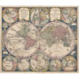
![Nicolas Sanson 1743 [Lot of 3] Mappe-Monde ou Carte Generale du Globe Terrestre Representee en](https://portal-images.azureedge.net/auctions-2016/srol10009/images/1d97f6e0-cb69-458d-af24-1ea4d64b5b47.jpg?w=155&h=155)
Nicolas Sanson 1743 [Lot of 3] Mappe-Monde ou Carte Generale du Globe Terrestre Representee en
Nicolas Sanson 1743 [Lot of 3] Mappe-Monde ou Carte Generale du Globe Terrestre Representee en Deux Plan-Hemispheres... [and] Le Globe Celeste, ou...
Isaac Tirion 1744 Wereld-Kaart na de Alderlaatste Ontdekking in't Licht Gebragt Handsome double
Isaac Tirion 1744 Wereld-Kaart na de Alderlaatste Ontdekking in't Licht Gebragt Handsome double hemisphere map with polar projections tucked betwe...
![Jan Van Jagen 1748 [Untitled - World] Lovely double hemisphere from a Dutch Bible published by the](https://portal-images.azureedge.net/auctions-2016/srol10009/images/a1f38114-948d-4813-8273-30731262c00d.jpg?w=155&h=155)
Jan Van Jagen 1748 [Untitled - World] Lovely double hemisphere from a Dutch Bible published by the
Jan Van Jagen 1748 [Untitled - World] Lovely double hemisphere from a Dutch Bible published by the Keur family. The map is surrounded by allegori...
Benjamin Cole 1757 A Physical Planisphere Wherein Are Represented All the Known Lands and Seas
Benjamin Cole 1757 A Physical Planisphere Wherein Are Represented All the Known Lands and Seas wth. the Great Chains of Mountains... Very unusual ...
Brouckner/Remondini 1761 Carte Generale du Globe Terrestre... This uncommon map is Remondini's
Brouckner/Remondini 1761 Carte Generale du Globe Terrestre... This uncommon map is Remondini's reduction of Isaak Brouckner's map of the world. I...
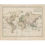
Janvier/Lattre 1775 Mappe-Monde ou Description du Globe Terrestre, Assujettie aux Observations
Janvier/Lattre 1775 Mappe-Monde ou Description du Globe Terrestre, Assujettie aux Observations Astronomiques A lovely double hemisphere map with a...
Cook/Benard 1784 Carte Generale Offrant les Decouvertes Faites par le Capitaine Jacques Cook dans ce
Cook/Benard 1784 Carte Generale Offrant les Decouvertes Faites par le Capitaine Jacques Cook dans ce Voyage ey dans les Deux Voyages Precedens; Ai...
Pierre Francois Tardieu 1785 Mappe-Monde Suivant la Projection des Cartes Reduites; ou l'on a
Pierre Francois Tardieu 1785 Mappe-Monde Suivant la Projection des Cartes Reduites; ou l'on a Trace les Routes de Mr. de Bougainville, et les Deux...
Jocob Keizer & Jan De Lat 1786 De Wareld in een Ronde Gedaante van de Noord Pool te Zien [on sheet
Jocob Keizer & Jan De Lat 1786 De Wareld in een Ronde Gedaante van de Noord Pool te Zien [on sheet with] De Wareld verbeeld in de gedaante van een...
![See description. 1796-1800 [Lot of 2] World from the Best Authorities [and] Chart of the World on](https://portal-images.azureedge.net/auctions-2016/srol10009/images/e8df84d9-0813-4da4-80e0-84673cd7b344.jpg?w=155&h=155)
See description. 1796-1800 [Lot of 2] World from the Best Authorities [and] Chart of the World on
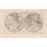
See description. 1796-1800 [Lot of 2] World from the Best Authorities [and] Chart of the World on Mercators Projection A. World from the Best Auth...
Andrew Bell 1798 Geography. Map of the World, Comprehending the Latest Discoverys This elegantly
Andrew Bell 1798 Geography. Map of the World, Comprehending the Latest Discoverys This elegantly engraved double-hemisphere world map shows the t...
![Adrien Hubert Brue 1816 [On 4 Sheets] Mappe-Monde sur la Projection de Mercator Carte Encyprotype...](https://portal-images.azureedge.net/auctions-2016/srol10009/images/cc09f282-d3f9-417e-b072-4a84cfe6997a.jpg?w=155&h=155)
Adrien Hubert Brue 1816 [On 4 Sheets] Mappe-Monde sur la Projection de Mercator Carte Encyprotype...
Adrien Hubert Brue 1816 [On 4 Sheets] Mappe-Monde sur la Projection de Mercator Carte Encyprotype... This uncommon large-scale map of the world wa...
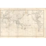
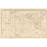
Auguste-Henri Dufour 1860 Mappe-Monde Planispherique Physique et Hydrographique The world on Mercator's projection with fine detail throughout. I...
![National Geographic Magazine 1928 [Lot of 2] Western Hemisphere - Map of Discovery [and] Eastern](https://portal-images.azureedge.net/auctions-2016/srol10009/images/93608438-e40c-4d80-af99-bb2a7ef5b183.jpg?w=155&h=155)
National Geographic Magazine 1928 [Lot of 2] Western Hemisphere - Map of Discovery [and] Eastern
National Geographic Magazine 1928 [Lot of 2] Western Hemisphere - Map of Discovery [and] Eastern Hemisphere - Map of Discovery This attractive pai...
![See description. 1942-45 [Lot of 2] Dated Events War Map [and] Dated Events Map of World Victory V-e](https://portal-images.azureedge.net/auctions-2016/srol10009/images/08c78073-22d4-4b83-82a9-5440657edae4.jpg?w=155&h=155)
See description. 1942-45 [Lot of 2] Dated Events War Map [and] Dated Events Map of World Victory V-e
See description. 1942-45 [Lot of 2] Dated Events War Map [and] Dated Events Map of World Victory V-e Day V-j Day Edition This lot consists of two ...
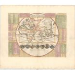
![See description. 1564 [Daniel's Dream Map] This unusual little map is also known as the Wittenberg](https://portal-images.azureedge.net/auctions-2016/srol10009/images/22b3a23e-5703-4de6-cf96-5b216ed228d0.jpg?w=155&h=155)
See description. 1564 [Daniel's Dream Map] This unusual little map is also known as the Wittenberg
See description. 1564 [Daniel's Dream Map] This unusual little map is also known as the Wittenberg world map. It represents Daniel's interpretati...
![Philippe Briet 1649 [Lot of 2] Antiquissima Orbis Delineatio [and] Les Divisions de la](https://portal-images.azureedge.net/auctions-2016/srol10009/images/3e014407-293a-4547-a2f8-efd7e83d5882.jpg?w=155&h=155)
Philippe Briet 1649 [Lot of 2] Antiquissima Orbis Delineatio [and] Les Divisions de la Mediterranee Selon les Modernes A. Antiquissima Orbis Delin...
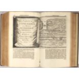
See description. 1682 Tabula Itineraria ex Illustri Peutingerorum Bibliotheca ... Marci Velseri [
See description. 1682 Tabula Itineraria ex Illustri Peutingerorum Bibliotheca ... Marci Velseri [in book] Opera Historica et Philologica, Sacra et...
![Romain de Hooghe 1687 [Prophetien - Vervullingen] This is a very unusual Bible map with a hemisphere](https://portal-images.azureedge.net/auctions-2016/srol10009/images/c79cba44-914b-4bc6-ce51-cc311c11f12d.jpg?w=155&h=155)
Romain de Hooghe 1687 [Prophetien - Vervullingen] This is a very unusual Bible map with a hemisphere
Romain de Hooghe 1687 [Prophetien - Vervullingen] This is a very unusual Bible map with a hemisphere depicting the Old World suspended above a sce...
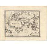
Philippe Briet 1649 La Division de Nostre Ocean This map of the eastern hemisphere identifies each
Philippe Briet 1649 La Division de Nostre Ocean This map of the eastern hemisphere identifies each of the oceans and shows the divisions between t...
Emanuel Bowen 1730 A Map of Marco Polo's Voyages & Travels in the 13th Century Through a Great
Emanuel Bowen 1730 A Map of Marco Polo's Voyages & Travels in the 13th Century Through a Great Part of Asia, All Tartary, the East India Islands &...
Sir John Barrow 1796 A General Chart, on Mercator's Projection, to Shew the Track of the Lion and
Sir John Barrow 1796 A General Chart, on Mercator's Projection, to Shew the Track of the Lion and Hindostan from England to the Gulph of Pekin in ...
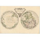
Maurille Antoine Moithey 1769 Le Globe Terrestre Vu en Convexe par les Deux Poles, l'Equateur
Maurille Antoine Moithey 1769 Le Globe Terrestre Vu en Convexe par les Deux Poles, l'Equateur Servant d'Horison This rare map is depicted on Cassi...
![Buffon 1798-99 Carte des Deux Regions Polaires [bound in] Histoire Naturelle, Generale et](https://portal-images.azureedge.net/auctions-2016/srol10009/images/520b0daa-ab52-402f-e0dc-40f6399a767b.jpg?w=155&h=155)
Buffon 1798-99 Carte des Deux Regions Polaires [bound in] Histoire Naturelle, Generale et Particuliere ... Tome Quatrieme This interesting map of ...
Mercator/Hondius 1619 Septentrionalium Terrarum Descriptio This influential map was the first
Mercator/Hondius 1619 Septentrionalium Terrarum Descriptio This influential map was the first separately printed map devoted to the Arctic. The h...
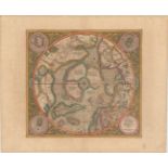
Samuel John Neele 1808 A Map of the Countries Thirty Degrees Round the North Pole This map shows the
Samuel John Neele 1808 A Map of the Countries Thirty Degrees Round the North Pole This map shows the extent of polar geographical knowledge at the...
Cook/Benard 1775 Carte de l'Hemisphere Austral Montrant les Routes des Navigateurs les Plus Celebres
Cook/Benard 1775 Carte de l'Hemisphere Austral Montrant les Routes des Navigateurs les Plus Celebres par le Capitaine Jacques Cook This scarce cha...
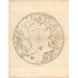
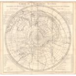
Edward Stanford 1905 The Antarctic Regions This attractive chart of the South Pole depicts the known
Edward Stanford 1905 The Antarctic Regions This attractive chart of the South Pole depicts the known portions of Antarctica. The central white ar...
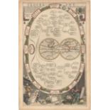
Doppelmayr/Homann 1742 Motus in Coelo Spirales quos Planetae Inferiores Venus et Mercurius Secundum Tychonicorum Hypothesin... This whimsical cele...
![Hartmann Schedel 1493 Folio V [Creation] An important leaf from the Creation of the World series.](https://portal-images.azureedge.net/auctions-2016/srol10009/images/3ba61a49-7b7b-4a21-ed9c-ba9b36ec2e37.jpg?w=155&h=155)
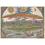
Hartmann Schedel 1493 Folio V [Creation] An important leaf from the Creation of the World series.
Hartmann Schedel 1493 Folio V [Creation] An important leaf from the Creation of the World series. The recto features the illustration representin...