Filtered by:
- Category
- List
- Grid
A subscription to the Price Guide is required to view results for auctions ten days or older. Click here for more information
![Collection of 10 maps, including Saxton, C.Barkshyre. [c.1637] and Huntingdon [c.1637], foot of](https://portal-images.azureedge.net/auctions-2016/srly10096/images/5a0090ce-5e7b-4a87-9461-ffd6afd398f0.jpg?w=155&h=155)

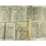
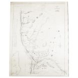
Collection of 10 maps, including Saxton, C.Barkshyre. [c.1637] and Huntingdon [c.1637], foot of
Collection of 10 maps, including Saxton, C.Barkshyre. [c.1637] and Huntingdon [c.1637], foot of map trimmed; Blome, Richard A Mapp of Hartfordshir...
Cumberland, Westmorland and Lancashire, maps, including Saxton, C.Cumbria sive Cumberlandia. Engraved map, hand-coloured in outline, 280 x 320mm.,...
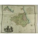
Durham, 4 maps, comprising: Greenwood, C. & J.Map of the County Palatine of Durham. Jan. 26 1831.
Durham, 4 maps, comprising: Greenwood, C. & J.Map of the County Palatine of Durham. Jan. 26 1831. Hand-coloured engraved map, 586 x 695mm., Cary, ...
Northumberland - 7 maps, comprising:Mercator, Gerhard and Henrik Hondius. Northumbria, Cumberlandia et Dunelmensis Episcopatus. [Amsterdam, c.1620...
2 Geographia Antiqua map volumes including Lenglet Du Fresnoy, Pierre Nicolas, l'abbéGeographia
2 Geographia Antiqua map volumes including Lenglet Du Fresnoy, Pierre Nicolas, l'abbéGeographia Antiqua et Nova, or a system of antient and modern...
Ayrshire, Argyll & KintyreRobert Aitken Map of the Parish of Kilbirnie. Surveyed 1827. Edinburgh: W.
Ayrshire, Argyll & KintyreRobert Aitken Map of the Parish of Kilbirnie. Surveyed 1827. Edinburgh: W. Ballantine, 1828. Engraved map, 55.5 x 43.5 c...
Campbell, LieutenantA New and Correct Map of Scotland or North Britain. London: Laurie & Whittle,
Campbell, LieutenantA New and Correct Map of Scotland or North Britain. London: Laurie & Whittle, 1794. Folded map on 2 sheets, each c.107 x 66 cm...
Jacobite interest, dedicated to the Duke of Cumberland - Cooper, RichardA Map of His Majesty's Roads
Jacobite interest, dedicated to the Duke of Cumberland - Cooper, RichardA Map of His Majesty's Roads from Edinburgh to Inverness, Fort Augustus & ...
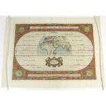
Ortelius, Abraham - map of the worldAevi Veteris, Typus Geographicus. Antwerp, 1590, 29 x 54 cm,
Ortelius, Abraham - map of the worldAevi Veteris, Typus Geographicus. Antwerp, 1590, 29 x 54 cm, later hand-colouring ...[more]
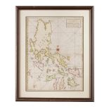
Philippines - Anson, GeorgeA Chart of the Channel in the Phillippine Islands through which the
Philippines - Anson, GeorgeA Chart of the Channel in the Phillippine Islands through which the Manila Galeon passes together with the adjacent Isl...
Railway Map - George BradshawMap & Sections of the Railways of Great Britain. Manchester: G.
Railway Map - George BradshawMap & Sections of the Railways of Great Britain. Manchester: G. Bradshaw, 1839. First edition, large engraved map, di...
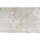
Scotland - Taylor, George & Skinner, Andrew, 7 maps, and one other7 sheets from Taylor & Skinner's
Scotland - Taylor, George & Skinner, Andrew, 7 maps, and one other7 sheets from Taylor & Skinner's Survey and Maps of the Roads of North Britain o...
Speed, John - MiddlesexMidle-Sex described with the most famous cities of London and Westminster. [
Speed, John - MiddlesexMidle-Sex described with the most famous cities of London and Westminster. [London]: George Humble, [1627?], 32 x 43 cm, a ...
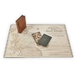
Russia - D'Auteroche, M. L'Abbé ChappeA Journey into Siberia... London: T. Jeffreys, 1770. 4to,
Russia - D'Auteroche, M. L'Abbé ChappeA Journey into Siberia... London: T. Jeffreys, 1770. 4to, folding map with some light hand-colouring, 9 plat...
![Russia - D'Auteroche, M. L'Abbé Chappe - [Le Prince, Jean Baptiste]Carte Générale - la France et l'](https://portal-images.azureedge.net/auctions-2016/srly10096/images/d708abf1-4b66-49bc-f861-d036ef576593.jpg?w=155&h=155)
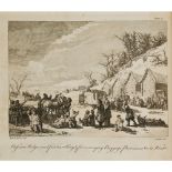
Russia - D'Auteroche, M. L'Abbé Chappe - [Le Prince, Jean Baptiste]Carte Générale - la France et l'
Russia - D'Auteroche, M. L'Abbé Chappe - [Le Prince, Jean Baptiste]Carte Générale - la France et l'Empire, la Pologne et la Russie. [N.p., n.d. bu...
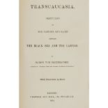
Russia - Haxthausen, Baron vonTranscaucasia... London: Chapman and Hall, 1854. 8vo, 8 colour
Russia - Haxthausen, Baron vonTranscaucasia... London: Chapman and Hall, 1854. 8vo, 8 colour lithographed plates, folding map, original cloth, end...
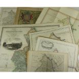
Miscellaneous Travel, includingAn Atlas to Guthrie's Geographical Grammar. 1824. 8vo, double-page
Miscellaneous Travel, includingAn Atlas to Guthrie's Geographical Grammar. 1824. 8vo, double-page engraved maps, hand-coloured in outline, one pla...
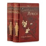
Stanley, Henry M.In Darkest Africa... London: Sampson Low, Marston, Searle and Rivington Limited,
Stanley, Henry M.In Darkest Africa... London: Sampson Low, Marston, Searle and Rivington Limited, 1890. 2 volumes, 8vo, plates and maps, original ...
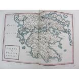
![[Barthelemy, J.J.]Maps, Plans, Views and Coins, Iillustrative of the Travels of Anacharsis the](https://portal-images.azureedge.net/auctions-2016/srly10096/images/15f32952-9129-45a7-d299-441eccc210e2.jpg?w=155&h=155)
[Barthelemy, J.J.]Maps, Plans, Views and Coins, Iillustrative of the Travels of Anacharsis the
[Barthelemy, J.J.]Maps, Plans, Views and Coins, Iillustrative of the Travels of Anacharsis the Younger. London, 1793. 4to., (plate volume only), 3...