Filtered by:
- Category
- List
- Grid
A subscription to the Price Guide is required to view results for auctions ten days or older. Click here for more information

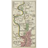
Game. A New Royal Geographical Pastime for England and Wales wherein The Distance of each Town is
Game. A New Royal Geographical Pastime for England and Wales wherein The Distance of each Town is Laid Down from London in Measured Miles; being a...
Black, Adam and Charles. Black's Picturesque Tourist and Road-Book of England and Wales, large
Black, Adam and Charles. Black's Picturesque Tourist and Road-Book of England and Wales, large folding general map, backed on linen, 10 engraved m...
Mogg, Edward. Paterson's Roads, large folding engraved map, repaired, 7 folding engraved plates,
Mogg, Edward. Paterson's Roads, large folding engraved map, repaired, 7 folding engraved plates, contemporary half calf, rubbed, joints cracked, 8...
Ashmead, G.C. Ashmead's Map of the City and Borough of Bristol..., large folding engraved map in
Ashmead, G.C. Ashmead's Map of the City and Borough of Bristol..., large folding engraved map in 24 sections, backed on linen, in cloth boards, 87...
Glastonbury. A Valuable Freehold Estate... comprising the Elegant and Distinguished Mansion known as
Glastonbury. A Valuable Freehold Estate... comprising the Elegant and Distinguished Mansion known as The Abbey House... in a portion of the Ground...
Godwin, H. A New and Correct Plan of the City of Bath, folding engraved map in 12 sections, backed
Godwin, H. A New and Correct Plan of the City of Bath, folding engraved map in 12 sections, backed on linen, in original slipcase, 520mm x 444mm, ...
Cooke, Edward. A Voyage to the South Sea, and Round the World, Perform'd in the Years 1708, 1709,
Cooke, Edward. A Voyage to the South Sea, and Round the World, Perform'd in the Years 1708, 1709, 1710, and 1711, first edition, 13 [of 20] engrav...
Ireland. The Traveller's New Guide through Ireland, engraved frontispiece, folding engraved map,
Ireland. The Traveller's New Guide through Ireland, engraved frontispiece, folding engraved map, 10 single-page engraved road maps, folding map of...
Bartholomew, John. The Imperial Map of England and Wales, 15 double-page engraved maps hand-coloured
Bartholomew, John. The Imperial Map of England and Wales, 15 double-page engraved maps hand-coloured in outline and 3 partial maps, one split alon...
Bowen, Emmanuel. An Accurate Map of the County of Sussex. Divided into its Rapes, Deanries and
Bowen, Emmanuel. An Accurate Map of the County of Sussex. Divided into its Rapes, Deanries and Hundreds, hand-coloured engraved map, 685mm x 505mm...
Cary, John. Cary's New and Correct English Atlas: being A New Set of County Maps, engraved title and
Cary, John. Cary's New and Correct English Atlas: being A New Set of County Maps, engraved title and dedication leaf, 47 hand-coloured engraved co...
Cary, John. Cary's New Map of England and Wales, with part of Scotland, engraved title, dedication
Cary, John. Cary's New Map of England and Wales, with part of Scotland, engraved title, dedication leaf and hand-coloured general map, 76 hand-col...
Cary, John. Cary's Traveller's Companion, or, A Delineation of the Turnpike Roads of England and
Cary, John. Cary's Traveller's Companion, or, A Delineation of the Turnpike Roads of England and Wales, engraved title-page, advertisement and con...
Cary, John. Cary's Actual Survey of the Great Post Roads between London and Falmouth, including a
Cary, John. Cary's Actual Survey of the Great Post Roads between London and Falmouth, including a branch to Weymouth..., first edition, engraved t...
D'Anville, Jean Baptiste. [A Complete Body of Ancient Geography], 10 [of 12] engraved maps only,
D'Anville, Jean Baptiste. [A Complete Body of Ancient Geography], 10 [of 12] engraved maps only, hand-coloured in outline, loose in contemporary h...
Heirs, Hermann. Regnorum Magnae Britanniae et Hiberniae Mappa Geographica, hand-coloured engraved
Heirs, Hermann. Regnorum Magnae Britanniae et Hiberniae Mappa Geographica, hand-coloured engraved map, faded, 562mm x 520mm, Nuremberg, 1749, fram...
Kip, William. Essexia Comitatus qvem olim Trinobantes, hand-coloured engraved map, heavily browned, 370mm x 290mm, [c.1610]; Morden, Robert. Suffo...
Kip, William. Dorcestriae Comitatis, vulgo Dorsett, hand-coloured engraved map, 386mm x 275mm, [c.
Kip, William. Dorcestriae Comitatis, vulgo Dorsett, hand-coloured engraved map, 386mm x 275mm, [c.1637], framed and glazed
Kitchin, Thomas. An Accurate Map of Glamorganshire, engraved map, hand-coloured in outline, 538mm
Kitchin, Thomas. An Accurate Map of Glamorganshire, engraved map, hand-coloured in outline, 538mm x 360mm, Carrington Bowles, [n.d.]; Modern, Robe...
Mercator, Gerard. Cornubia, Devonia, Somersetus, Dorcestria, Wiltonia, Glocestria..., hand-
Mercator, Gerard. Cornubia, Devonia, Somersetus, Dorcestria, Wiltonia, Glocestria..., hand-coloured engraved map, 470mm x 370mm, [c.1630], framed ...
Miller, Robert. Miller's New Miniature Atlas, containing a complete set of County Maps, in which are
Miller, Robert. Miller's New Miniature Atlas, containing a complete set of County Maps, in which are carefully delineated All the Principal Direct...
Smith, C. A New Map of the County of Somerset, folding hand-coloured engraved map in 12 sections,
Smith, C. A New Map of the County of Somerset, folding hand-coloured engraved map in 12 sections, backed on linen, in original slipcase, 530mm x 4...
Stanford, Edward. Map of London with its Postal Sub-Divisions, folding hand-coloured engraved map in
Stanford, Edward. Map of London with its Postal Sub-Divisions, folding hand-coloured engraved map in 32 sections, backed on linen, in original sli...
Taylor, George and Andrew Skinner. Maps of the Roads of Ireland, Surveyed 1777, engraved title and
Taylor, George and Andrew Skinner. Maps of the Roads of Ireland, Surveyed 1777, engraved title and dedication, 288 engraved strip-maps on 144 leav...
Teesdale, Henry. A New General Atlas of the World... containing separate maps of its various
Teesdale, Henry. A New General Atlas of the World... containing separate maps of its various countries and states... also the British and Foreign ...
Wilkinson, Robert. Atlas Classica, being a Collection of Maps of the Countries Mentioned by the
Wilkinson, Robert. Atlas Classica, being a Collection of Maps of the Countries Mentioned by the Ancient Authors, both Sacred and Profane, engraved...
Wilkinson, Robert. General Atlas of the World..., engraved title, 46 hand-coloured engraved maps,
Wilkinson, Robert. General Atlas of the World..., engraved title, 46 hand-coloured engraved maps, 2 double-page, some browning and minor spotting,...
Baldwin, William Charles. African Hunting and Adventure, Second Edition, 1863. Cont.half calf (
Baldwin, William Charles. African Hunting and Adventure, Second Edition, 1863. Cont.half calf (scuffed). Folding map and plates, some tinted litho...
Johnston, A.K. Atlas to Alison's History of Europe, Edinburgh and London, 1848. Oblong 4to., cont.
Johnston, A.K. Atlas to Alison's History of Europe, Edinburgh and London, 1848. Oblong 4to., cont. half leather. Engraved frontispiece, folding ma...
Speed, John. The Countye of Monmouth…1610 (or later). Hand coloured engraved map. 39 x 51 cms. Mona
Speed, John. The Countye of Monmouth…1610 (or later). Hand coloured engraved map. 39 x 51 cms. Mona [Isle of Man], ? Blaeu, Amsterdam, 1645. Han...
Wilson, Robert Thomas. History of the British Expedition to Egypt, Second Edition, 1803. 4to., cont.
Wilson, Robert Thomas. History of the British Expedition to Egypt, Second Edition, 1803. 4to., cont. calf. Engraved portrait and 4 folding maps (2...