
Refine your search
Sale Section
Remove filter- Maps, Prints Etc. (25)
Estimate
Category
Filtered by:
- Lots with images only,
- Sale Section
- List
- Grid
A subscription to the Price Guide is required to view results for auctions ten days or older. Click here for more information
![J SPEEDE: RUTLANDSHIRE, engrvd map [1611], approx 14 3/4" x 19 1/2", f/g](https://portal-images.azureedge.net/auctions-2015/srkey10075/images/ebdba71f-c094-4782-add9-341d475a84ec.jpg?w=155&h=155)

J SPEEDE: RUTLANDSHIRE, engrvd map [1611], approx 14 3/4" x 19 1/2", f/g

Heirs of JOHANN BAPTISTE HOMANN: A GENERAL MAP OF GREAT BRITAIN AND IRELAND WITH PART OF HOLLAND,
Heirs of JOHANN BAPTISTE HOMANN: A GENERAL MAP OF GREAT BRITAIN AND IRELAND WITH PART OF HOLLAND, FLANDERS, FRANCE ETC AGREEABLE TO MODERN HISTORY...

J JANSSON: COMITATUS DORSESTRIA…., engrvd hand col'd map circa 1646, approx 14" x 18 1/2" f/g
J JANSSON: COMITATUS DORSESTRIA…., engrvd hand col'd map circa 1646, approx 14" x 18 1/2" f/g
![J SPEEDE: NORFOLK…, engrvd map [1627], approx 12 1/4" x 19 1/2" f/g](https://portal-images.azureedge.net/auctions-2015/srkey10075/images/e664ee29-8594-46ce-e9cc-641e22ea3adf.jpg?w=155&h=155)
J SPEEDE: NORFOLK…, engrvd map [1627], approx 12 1/4" x 19 1/2" f/g

T KITCHIN: A PLAN OF THE CITY OF ST PETERSBURGH, engrvd hand col'd plan 1784, approx 10" x 11 1/2"
T KITCHIN: A PLAN OF THE CITY OF ST PETERSBURGH, engrvd hand col'd plan 1784, approx 10" x 11 1/2" f/g

J WELLS: PHELPS AND ENSIGN'S TRAVELLERS GUIDE AND MAP OF UNITED STATES CONTAINING THE ROADS,
J WELLS: PHELPS AND ENSIGN'S TRAVELLERS GUIDE AND MAP OF UNITED STATES CONTAINING THE ROADS, DISTANCES, STEAM BOAT AND CANAL ROUTES ETC..., engrvd...

Depot de la Marine, CARTE REDUITE DES ISLES BRITANNIQUES..., engrvd hand col'd map 1757, approx 21
Depot de la Marine, CARTE REDUITE DES ISLES BRITANNIQUES..., engrvd hand col'd map 1757, approx 21 3/4" x 33 1/4"

J DALLINGER: PLAN OF THE CITY OF NORWICH SURVEYED BY W S MILLARD AND JOS MANNING, engrvd large scale
J DALLINGER: PLAN OF THE CITY OF NORWICH SURVEYED BY W S MILLARD AND JOS MANNING, engrvd large scale plan 1830, bkd onto linen, mntd on roller, ap...

J CLEAVERS: A CHART OF THE BAY OF GIBRALTAR INCLUDING A SMALL PLAN OF THAT FORTRESS WITH THE
J CLEAVERS: A CHART OF THE BAY OF GIBRALTAR INCLUDING A SMALL PLAN OF THAT FORTRESS WITH THE POSITION OF THE MILITARY AND NAVAL FORCE OF FRANCE AN...

J OGILBY: THE ROAD FROM LONDON TO WEYMOUTH..., engrvd hand col'd road map circa 1675, approx 13 1/2"
J OGILBY: THE ROAD FROM LONDON TO WEYMOUTH..., engrvd hand col'd road map circa 1675, approx 13 1/2" x 18"

Packet six assorted 19th Century and earlier maps of Ireland (6)
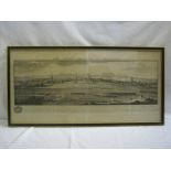
S & N BUCK: THE SOUTH PROSPECT OF LEICESTER, engrd prospect approx 17" x 34", f/g

Packet of four early 20th Century Ordnance Survey maps, fdg bkd onto linen, sheets 62, 268-270 +
Packet of four early 20th Century Ordnance Survey maps, fdg bkd onto linen, sheets 62, 268-270 + BEACON'S MOTORING AND CYCLING ROAD MAP OF ENGLAND...

Packet of fifteen J PYNE hand col'd costume prints pub 1804-05,

THE WORLD, 4 col'd litho prints, The Marquis of Lansdowne, The Earl of Suffolk and Berkshire, Rt Rev
THE WORLD, 4 col'd litho prints, The Marquis of Lansdowne, The Earl of Suffolk and Berkshire, Rt Rev The Bishop of London and The Earl of Cromer, ...

Six Vanity Fair col'd litho prints, Judges and Barristers, all f/g (6)

Box large qty East Anglia large scale Ordnance Survey maps

Vanity Fair col'd litho dbl size print "Heads of The Law", approx 12" x 18", f/g + Vanity Fair Spy
Vanity Fair col'd litho dbl size print "Heads of The Law", approx 12" x 18", f/g + Vanity Fair Spy col'd litho print "The Exchequer", pub January ...

Eight orig pen and ink Railway Plans, parts of Essex, some with added watercolour including Earls
Eight orig pen and ink Railway Plans, parts of Essex, some with added watercolour including Earls Colne, Saffron Waldon etc, late 19th/early 20th ...

Seven orig pen and ink Railway Plans, parts of Suffolk, some with added watercolour including
Seven orig pen and ink Railway Plans, parts of Suffolk, some with added watercolour including Welnetham, Withersfield, Sutton etc, late 19th/early...

Seven assorted pen and ink Railway Plans, parts of Suffolk, some with added watercolour including
Seven assorted pen and ink Railway Plans, parts of Suffolk, some with added watercolour including Marlesford, Parham, Cavendish etc, late 19th/ear...

Two orig pen and ink Railway Plans, with added watercolour, North Walsham - Mundesley, Mundesley -
Two orig pen and ink Railway Plans, with added watercolour, North Walsham - Mundesley, Mundesley - Cromer, late 19th/early 20th Century (2)

Ten orig pen and ink Railway Plans, with added watercolour, including Watton, Swaffham, Knapton,
Ten orig pen and ink Railway Plans, with added watercolour, including Watton, Swaffham, Knapton, Barnham, Emneth etch, late 19th/early 20th Centur...

Eleven pen and ink Railway Plans, parts of Norfolk, mainly with added watercolour, including
Eleven pen and ink Railway Plans, parts of Norfolk, mainly with added watercolour, including Foulsham, East Winch, Ingham, Dunham etc, late 19th/e...

Seven orig pen and ink Railway Plans, parts of Cambs, most with added watercolour, including St Ives
Seven orig pen and ink Railway Plans, parts of Cambs, most with added watercolour, including St Ives - March, Pampisford, Wilburton etc, late 19th...