Filtered by:
- Category
- List
- Grid
A subscription to the Price Guide is required to view results for auctions ten days or older. Click here for more information
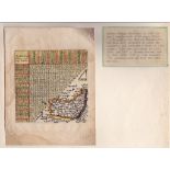

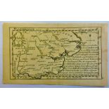
Antique Maps-1635-(1643 Edition) "Directions for English Travellor" by Thomas Jennes, includes a
Antique Maps-1635-(1643 Edition) "Directions for English Travellor" by Thomas Jennes, includes a table of distance,10x10cm, very fine, some water ...
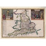
Antique Maps - England, Hermannides,1661 Map and Cartouches 'Britannia Saxonica' from Britannia
Antique Maps - England, Hermannides,1661 Map and Cartouches 'Britannia Saxonica' from Britannia Magna(Amsterdam) engraved by M Burghers. A rare co...
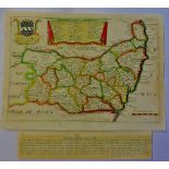
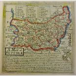
Antique Maps - Suffolk Blome, R1693 Map from ' Cosmography' decorative, dedicated to Charles, Lord
Antique Maps - Suffolk Blome, R1693 Map from ' Cosmography' decorative, dedicated to Charles, Lord Cornwallis, |Baron of Eyr(Arm Inset) Hundred of...
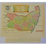
Antique Maps - Suffolk,Taylor-Blome,1715 map from 'England Exactly Described' decorative with Lord
Antique Maps - Suffolk,Taylor-Blome,1715 map from 'England Exactly Described' decorative with Lord Cornwallis Arms and Hundreds in Suffolk inset.2...
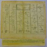
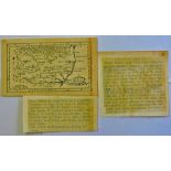
Antique Maps - 1719 Road Maps 'Ipswich to Norwich & Cromer' from Principle Roads of England and
Antique Maps - 1719 Road Maps 'Ipswich to Norwich & Cromer' from Principle Roads of England and Wales' Reduced from Ogilby, 22cm x 18cm, uncoloure...
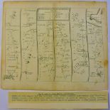
Antique Maps - 1719 Road Map - Kings Lynn to Harwich from 'Principle Roads of England and Wales'
Antique Maps - 1719 Road Map - Kings Lynn to Harwich from 'Principle Roads of England and Wales' reduced from Ogiby, 22cm x 15cm uncoloured, edge ...
Antique Maps-1751 Map of Suffolk-miniature from Britannia depicts, very fine 12cmx12cm
Antique Maps-1742 Edition 'Chordgraphica Britannia' by W.H.Toms - 18th Century mail routes showing
Antique Maps-1742 Edition 'Chordgraphica Britannia' by W.H.Toms - 18th Century mail routes showing recipients address and directions given by the ...
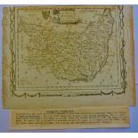
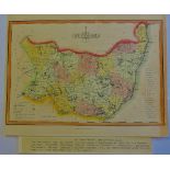
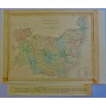
Antique Maps - 1759 Map from 'General magazines of Arts and Science/The Natural History of England, Hundreds inset, Burugh Towns, Market Towns and...
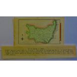
Antique Maps - 1764 map from 'England Illustrated'26mm x 19mm, very fine.
Antique Maps - 1769 map from 'England Displayed'(Previously small British Atlas)20cmx16cm, very
Antique Maps - 1769 map from 'England Displayed'(Previously small British Atlas)20cmx16cm, very fine.
Antique Maps - 1966 Map from Elliss English Atlas(copied from Kitchins map of 1764)25cmx19cm, very
Antique Maps - 1966 Map from Elliss English Atlas(copied from Kitchins map of 1764)25cmx19cm, very fine.
Antique Maps - 1769 map from New British Traveller(1784)embellished surrounds, published by Alexander Hogg, 21cmx16cm, very fine, some page edge t...
Antique Maps - 1787 Map from English Atlas or Concise View of England and Wales, 13cmx12cm, very
Antique Maps - 1787 Map from English Atlas or Concise View of England and Wales, 13cmx12cm, very fine(page 37)
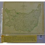
Antique Maps - 1807 Map from 'Universal Magazine' the Laurie and Whittles New and Improved Atlas
Antique Maps - 1807 Map from 'Universal Magazine' the Laurie and Whittles New and Improved Atlas 24cmx18cm very fine, some edge paper toned.
Antique Maps - 1810 Map from Wallis 'New Edition of the English Counties' miniature, 12cmx14cm,
Antique Maps - 1810 Map from Wallis 'New Edition of the English Counties' miniature, 12cmx14cm,very fine, with excessive misspelling for the perio...
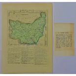
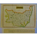
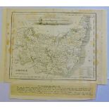
Antique Maps - 1812 map from 'New and Improved County Atlas, 26x18mm, very fine, hundreds listed
Antique Maps - 1812 map from 'New and Improved County Atlas, 26x18mm, very fine, hundreds listed inset.
Antique Maps - 1818 Map from 'Excursions through Suffolk' very fine, folding crease.
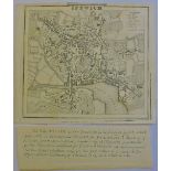
Antique Maps - 1817 Map Ipswich Town, from Excursions in Suffolk' folding crease, very fine.
Antique Maps - 1817 Map Ipswich Town, from Excursions in Suffolk' folding crease, very fine.
Antique Maps - 1828 Map from 'Encyclopaedia Londinensis' with many misspellings e.g.Hawkstead/
Antique Maps - 1828 Map from 'Encyclopaedia Londinensis' with many misspellings e.g.Hawkstead/Harkstead, Nedham/Needham, Eastrohoel/East Bergholt,...
Antique Maps - 1834 Map from the 'New British Atlas' very fine. 24cmx19cm.
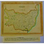
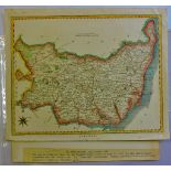
Antique Maps - 1846 Map from 'parliamentary Gazetteer of England and Wales'24cmx19cm, very fine,
Antique Maps - 1846 Map from 'parliamentary Gazetteer of England and Wales'24cmx19cm, very fine, some toning.
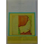
Antique Maps - 1830 Small maps from S.Leighs 'New Atlas of England and Wales,12cmx19cm.
Antique Maps - 1759 Miniature map from 'New and Accurate Maps of Countries of England and Wales',
Antique Maps - 1759 Miniature map from 'New and Accurate Maps of Countries of England and Wales',12cmx8cm,very fine, scarce.
Antigua Maps - 1759 Miniature Map from 'New and Accurate Maps of Countries of England and Wales'12cm
Antigua Maps - 1759 Miniature Map from 'New and Accurate Maps of Countries of England and Wales'12cm x 8 cm, very fine, scarce.
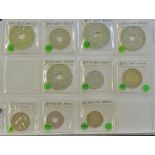
British West Africa Minors - 1910-1945 (10) Grade F to EF. ½d to 1/-.