Filtered by:
- Category
- List
- Grid
A subscription to the Price Guide is required to view results for auctions ten days or older. Click here for more information
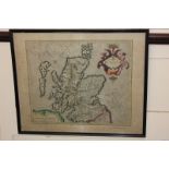

Geradus Mercator, Scotia Regnum, coloured engraved map of Scotland
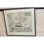
Robert Morden (c 1650-1703), map of the smaller islands in the British ocean featuring the Isle of
Robert Morden (c 1650-1703), map of the smaller islands in the British ocean featuring the Isle of Wight most prominently but also the Isle of Man...
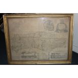
A 17th century map of Sussex titled Sussexia showing the six rapes with characters to show distinguishing places, hand coloured, 40cm by 23cm
An 18th century map of Sussex by Emanuel Bowen, with hand coloured details, 69cm by 51cm
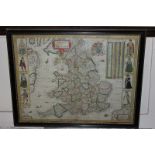
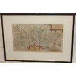
A 17th century map of The Kingdome of England by Abraham Goos Amsteloda, dated 1646, showing the
A 17th century map of The Kingdome of England by Abraham Goos Amsteloda, dated 1646, showing the counties of England and Wales, 51cm by 39cm, in d...
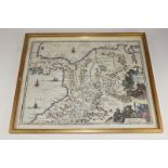
A 17th century map of Glamorganshire and Monmouthshire by Michael Drayton c.1612, decorated with
A 17th century map of Glamorganshire and Monmouthshire by Michael Drayton c.1612, decorated with mythical figures, 33cm by 25cm
17th century, South America map, Terra Firma et Novum Regnum Granatense et Popayan, hand coloured
17th century, South America map, Terra Firma et Novum Regnum Granatense et Popayan, hand coloured engraved map, illustrated with indigenous figure...
A copper reproduction of a celestial map with signs of the zodiac, framed, 38cm by 29cm, (SPM)
A copper reproduction of a celestial map with signs of the zodiac, framed, 38cm by 29cm, (SPM)