Refine your search
Sale Section
Remove filter- Books, Maps and Manuscripts (22)
Estimate
Category
Creator / Brand
Item Type
Filtered by:
- Sale Section
- List
- Grid
A subscription to the Price Guide is required to view results for auctions ten days or older. Click here for more information
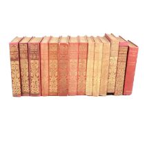

The Works of Rudyard Kipling, Edition De Luxe, early 1900's, various volumes including 1-16, 18-20, 22, 23, 25(x2), 26, 28-31, plus Departmental D...
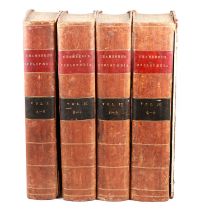
E Chambers, Cyclopaedia or an Universal Dictionary Arts & Sciences, with the supplement by Rees, printed for Rivington et al., late 18th century, ...
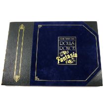
David Weston; Rolls Royce Fantasia,
David Weston; Rolls Royce Fantasia, limied edition of 850, in slip case, inscribed by the owner.Condition report:Please see additional uploaded im...
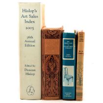
Books and catalogues
Books and catalogues including auction catalogues; Easton Neston, Interiors, etc., local history (Northamptonshire), art reference, etc.Qty: 4 box...
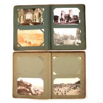
John Bridges, History & Antiquities of Northamptonshire, vol 1, postcard albums and a scrapbook,
John Bridges, History & Antiquities of Northamptonshire, vol 1, postcard albums and a scrapbook.Condition report:All the postcard albums and scrap...

Wolford Calendars, all 2000's.
Wolford Calendars, all 2000's.Qty: 6
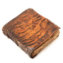
John Mayer(?), Commentary, 17th Century book.Condition report:The book is in poor condition, with no title page, and damage to all pages (curling,...
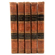
Small quantity of antiquarian books, three part sets including The History of England by C.M Cormick as a continuation of Hume and Smollett, 21vol...
Two maps,
John Speed, Northamptonshire, hand coloured map, 40x52cm, and Camden, Hiberniae Ireland Anglis. Yverdon Britannis Erin.., hand coloured map, 32x39...
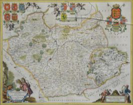
Johannes Blaeu,Leicestrensis Comitatus Leicester Shire,hand-coloured map,38x50cm.Condition report:Fair condition, some light fading and staining, ...
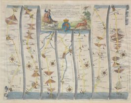
John Ogilby, Road from London to St Neots .. continued to Oakeham, 36x47cm; Emmanuel Bowen, Road
John Ogilby, Road from London to St Neots .. continued to Oakeham, 36x47cm; Emmanuel Bowen, Road from Hereford to Leicester, including a small map...
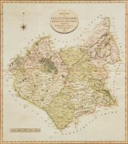
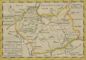
John Cary, New map of Leicestershire divided into hundreds, hand coloured County map, visible,
John Cary, New map of Leicestershire divided into hundreds, hand coloured County map, visible, 53x48cm; Robert Morden, Leicester Shire, hand colou...
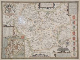
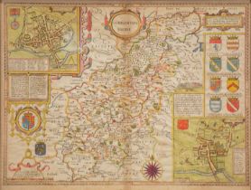
John Speed, Leicester, both Countye and Citie described, with a plan of Leicester, hand coloured
John Speed, Leicester, both Countye and Citie described, with a plan of Leicester, hand coloured County map, 39x50cm.
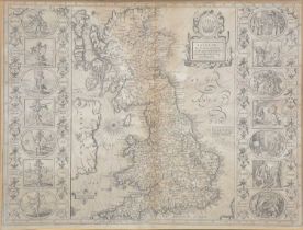
John Speed, Britain as it was divided in the tyme of the Englifhe Saxons efpecially during their
John Speed, Britain as it was divided in the tyme of the Englifhe Saxons efpecially during their heptarchy, an un-coloured map, banded with cartou...
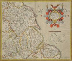
Gerald Mercator, Eboracum, Lincolnia, Derbie, Staffordia, Notinghamia, Lecestria, Rutlandia, et
Gerald Mercator, Eboracum, Lincolnia, Derbie, Staffordia, Notinghamia, Lecestria, Rutlandia, et forcia Norfolcia, hand coloured map of the Eastern...
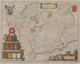
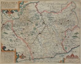
Jan Blaeu, Leicestrensis Comitatus, hand coloured County map, 39x50cm.
William Kip after Christopher Saxton, Lecestriae Comitatus Sive, hand coloured County map, 39x37cm.
William Kip after Christopher Saxton, Lecestriae Comitatus Sive, hand coloured County map, 39x37cm.
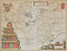
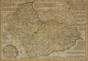
Jan Jansson, Leicestrensis Comitatus Cum Rutlandiae, hand coloured County map, 44x55cm.
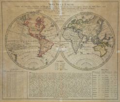
Homann Heirs, Neue Welt Karte, twin hemispherical World map, charting Goree's voyage in 1780,
Homann Heirs, Neue Welt Karte, twin hemispherical World map, charting Goree's voyage in 1780, Clerke's voyage in 1779, and Cook's voyage in 1777-7...
Pieter Van Den Keere, Leicestershire, a small hand coloured County map, visible, .5x12cm; John
Pieter Van Den Keere, Leicestershire, a small hand coloured County map, visible, .5x12cm; John Cowley, an improved map of Leicester-Shire; John Gi...
Emmanuel and Thomas Bowen, Leicester and Rutland divided into their respective hundreds, lightly
Emmanuel and Thomas Bowen, Leicester and Rutland divided into their respective hundreds, lightly coloured County map, visible, 23x32cm; John Ellis...

John Rocque, Leicestershire, un-coloured County map, visible, 16x20cm; and four other County maps,
John Rocque, Leicestershire, un-coloured County map, visible, 16x20cm; and four other County maps, Cole and Roper, John Archer, John Cary and J M ...