Refine your search
Sale Section
Remove filter- Antiquarian (109)
- Art Reference (25)
- British Topography (16)
- Caricatures (37)
- Cartons (13)
- Cotswold Watercolours (10)
- Decorative Prints & Original Art (55)
- Gasson Opera Collection: Part II (116)
- General Literature (27)
- Henry Irving & Ellen Terry (32)
- Maps (81)
- Music & Theatre: From Other Vendors (18)
- Natural History (26)
- Polar Exploration (22)
- Quantity (72)
- Regimental Histories (9)
- Travel (95)
Estimate
Category
- Books & Periodicals (410)
- Prints (122)
- Maps (105)
- Drawings & Pastels (21)
- Musical Instruments & Memorabilia (19)
- Collectables (16)
- Photographs (14)
- Watercolours (14)
- Sculpture (13)
- Models, Toys, Dolls & Games (9)
- Arms, Armour & Militaria (6)
- Ceramics (4)
- Oil, Acrylic paintings & Mixed Media (4)
- Stamps (3)
- Chinese Works of Art (1)
- Entertainment Memorabilia (1)
- Silver & Silver-plated items (1)
Filtered by:
- Sale Section
- List
- Grid
This auctioneer has chosen to not publish their results. Please contact them directly for any enquiries.
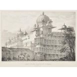

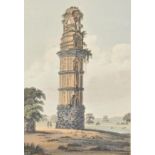
Bellew (Captain Francis John). Views in India, published for the author, 1833, lithographed title
Bellew (Captain Francis John). Views in India, published for the author, 1833, lithographed title vignette, 30 uncoloured lithographed views (comp...
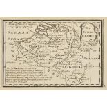
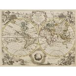
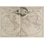
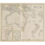
![Bellin (Jacques Nicolas). [Atlas, Cartes des Voyages], c.1780, lacking title and premilms.,](https://portal-images.azureedge.net/auctions-2015/srdom10015/images/dad21634-41e0-47aa-92f5-df3d13bae437.jpg?w=155&h=155)
Bellin (Jacques Nicolas). [Atlas, Cartes des Voyages], c.1780, lacking title and premilms., seventy-four uncoloured engraved maps including many f...
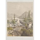
Benoist (Felix). Nice et Savoie Sites Pittoresques, Monuments, Description et Histoire des Departments..., reunis a la France en 1860, Paris: Henr...
Black (Adam & Charles, publishers). Black’s General Atlas of the World, New and Revised Edition,
Black (Adam & Charles, publishers). Black’s General Atlas of the World, New and Revised Edition, pub. Edinburgh, 1884, col. printed frontis. of ‘T...
Blackie (W.G., ed.). The Comprehensive Atlas & Geography of the World, pub. Blackie & Son, 1886,
Blackie (W.G., ed.). The Comprehensive Atlas & Geography of the World, pub. Blackie & Son, 1886, addn. half title, ten col. plts. of costumes and ...
Blaeu (Johannes). Le Grand Atlas ou Cosmographie Blaviane, 12 vols., pub. Amsterdam 1663, facsimile edition, pub. Theatrum Orbis Terrarum Ltd., 19...
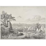
Boilly (Julien-Leopold). Vues Pittoresques de Montpellier, Girieud editeur, Montpellier, circa
Boilly (Julien-Leopold). Vues Pittoresques de Montpellier, Girieud editeur, Montpellier, circa 1840-50, ten uncoloured lithographic views, some sp...
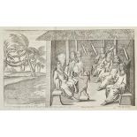
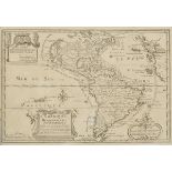
Bossu (Jean Bernard). Nouveaux Voyages dans l’Amerique Septentrionale, 1st ed., Amsterdam [Paris], Changuion, 1777, half title, four...
Bowen (Emmanuel). Atlas Minimus or a New Set of Pocket Maps of the Several Empires, Kingdoms and
Bowen (Emmanuel). Atlas Minimus or a New Set of Pocket Maps of the Several Empires, Kingdoms and States of the known World, Drawn and engraved by ...
Bres (Onorato). Malta Antica, illustrata co’monumenti e coll’istoria , Rome: Nella Stamperia de
Bres (Onorato). Malta Antica, illustrata co’monumenti e coll’istoria , Rome: Nella Stamperia de Romanis, 1816, half title, engraved vignette to ti...
Buck (Edward J.). Simla Past and Present, 2nd ed., Bombay, Times Press, 1925, numerous maps and
Buck (Edward J.). Simla Past and Present, 2nd ed., Bombay, Times Press, 1925, numerous maps and illustrations, previous owner note tipped-in at fr...
Carl (Katharine A.). With the Empress Dowager of China, 2nd UK impression, 1906, 22 half-tone
Carl (Katharine A.). With the Empress Dowager of China, 2nd UK impression, 1906, 22 half-tone plates, Working Men’s College Library stamps through...
Chaillu (Paul B. Du). The Land of the Midnight Sun: Summer and Winter Journeys through Sweden,
Chaillu (Paul B. Du). The Land of the Midnight Sun: Summer and Winter Journeys through Sweden, Norway, Lapland, and Northern Finland, 2 vols., 4th...
Clarke (J.). A Series of Twenty-Four Views Illustrative of The Holy Scriptures. Selected from Sir
Clarke (J.). A Series of Twenty-Four Views Illustrative of The Holy Scriptures. Selected from Sir Robert Ainslie’s Celebrated Collection of Drawin...
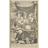
Cluver (Philipp). Introductionis in Universam Geographiam tam Veterem quam Novam Libri VI, edited by
Cluver (Philipp). Introductionis in Universam Geographiam tam Veterem quam Novam Libri VI, edited by Augustus Bruzen La Martiniere, pub. P. de Cou...
Cluverius (Philippus). Germaniae Antiquae, libri tres ... Adjectae sunt Vindelicia et Noricum, 4
Cluverius (Philippus). Germaniae Antiquae, libri tres ... Adjectae sunt Vindelicia et Noricum, 4 parts in one, 1st edition, Leiden, Ludovic Elzevi...
[Columbus, Christopher]. Nuova Raccolta Colombiana, English edition, 10 volumes bound in 14 (
[Columbus, Christopher]. Nuova Raccolta Colombiana, English edition, 10 volumes bound in 14 (including Atlas), Rome, 1990-97, colour and b & w map...
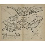
Coronelli (Vincenzo). Memoires, Historiques & Geographiques du Royaume de la Moree, Negrepont, & des
Coronelli (Vincenzo). Memoires, Historiques & Geographiques du Royaume de la Moree, Negrepont, & des Places Maritimes, Jusques a Thessalonique...,...
Covens (Jean & Mortier, Corneille). Nouvel Atlas Tres-exact et fort Commode pour toutes sortes de
Covens (Jean & Mortier, Corneille). Nouvel Atlas Tres-exact et fort Commode pour toutes sortes de Personnes Contenant. Les Pricipales Cartes Géogr...
Creighton (Henry). The Ruins of Gour Described and Represented in Eighteen Views; with a topographical map, 1st ed., 1817, half-title, folding han...
Cumming (C.F. Gordon). Granite Crags, 1st ed., pub. William Blackwood and Sons, 1884, eight b & w
Cumming (C.F. Gordon). Granite Crags, 1st ed., pub. William Blackwood and Sons, 1884, eight b & w plates, folding map at end, some marks to fronti...
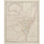
D’Hastrel (Adolfo). Album de la Plata o’Colleccion de las Vistas y Costumbres Remarcables de esta
D’Hastrel (Adolfo). Album de la Plata o’Colleccion de las Vistas y Costumbres Remarcables de esta parte de la America del Sur, 2nd ed., pub. Paris...
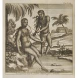
Dampier (William). Nouveau voyage autour du monde..., 5 vols., Amsterdam: Paul Marret, 1717, three
Dampier (William). Nouveau voyage autour du monde..., 5 vols., Amsterdam: Paul Marret, 1717, three engraved frontispieces, titles printed in red a...
Dampier (William). A New Voyage Round the World. Describing Particularly, the Isthmus of America, several Coasts and Islands in the W...
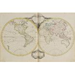
De l’Isle (Guillaume, and Buache, Philippe). Atlas Geographique et Universal, pub. Dezauche, Paris, 1781, dec. title page, eighty-nine (only) doub...
De Vaugondy (Robert). Nouvel Atlas Portatif destiné principalement pour L’instruction de la Jeunesee, pub. Paris, 1778, dec. title, contents list ...
Dieffenbach (Ernest). Travels in New Zealand; with Contributions to the Geography, Geology, Botany, and Natural History of that Country, 2 vols., ...
Doughty (Charles M.). Travels in Arabia Deserta, 2 vols., 1st ed., Cambridge, 1888, plates and
Doughty (Charles M.). Travels in Arabia Deserta, 2 vols., 1st ed., Cambridge, 1888, plates and illustrations, lacking folding map contained in vol...
Dower (John). A New General Atlas of Modern Geography Comprised in fifty-one Maps Compiled from
Dower (John). A New General Atlas of Modern Geography Comprised in fifty-one Maps Compiled from the Latest and best Authorities, pub. W.S.Orr & Co...
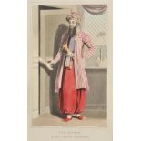
Drouville (Gaspard). Voyage en Perse, Fait en 1812 et 1813, 2 vols., 2nd ed., Paris, 1825, folding
Drouville (Gaspard). Voyage en Perse, Fait en 1812 et 1813, 2 vols., 2nd ed., Paris, 1825, folding hand-coloured engraved map, 60 hand-coloured li...
Dufour (Auguste Henri). Atlas Universel physique, historique et politique de Géographie ancienne
Dufour (Auguste Henri). Atlas Universel physique, historique et politique de Géographie ancienne et moderne, Paris, Armand Le Chevalier, 1863, for...
Dundas (Anne). Beneath African Glaciers; The Humours, Tragedies and Demands of an East African
Dundas (Anne). Beneath African Glaciers; The Humours, Tragedies and Demands of an East African Government Station as Experienced by an Official’s ...
East India Company. The East India Kalendar; or, Asiatic Register for Bengal, Madras, Bombay, Fort
East India Company. The East India Kalendar; or, Asiatic Register for Bengal, Madras, Bombay, Fort Marlborough, China, and St. Helena. For the Yea...
Eyre (Edward John). Journals of Expeditions of Discovery into Central Australia, and Overland from
Eyre (Edward John). Journals of Expeditions of Discovery into Central Australia, and Overland from Adelaide to King George’s Sound, in the Years 1...
Fer (Nicolas de). Introduction a la Geographie, avec une Description Historique sur touttes les
Fer (Nicolas de). Introduction a la Geographie, avec une Description Historique sur touttes les parties de la Terre, 2nd ed., Augmentee des Longti...
Fitzgerald (E.A.). Climbs in the New Zealand Alps. Being an Account of Travel and Discovery, 1st
Fitzgerald (E.A.). Climbs in the New Zealand Alps. Being an Account of Travel and Discovery, 1st ed., 1896, fifty b & w plates, folding map contai...
Florez (Henrique). Clave Geographica para aprender geographia los que no tienen maestro, Madrid:
Florez (Henrique). Clave Geographica para aprender geographia los que no tienen maestro, Madrid: Imprenta de la Viuda de Ibarra, 1802, half title,...
Gilbert (Josiah & Churchill, G.C.). The Dolomite Mountains. Excursions Through Tyrol, Carinthia,
Gilbert (Josiah & Churchill, G.C.). The Dolomite Mountains. Excursions Through Tyrol, Carinthia, Carniola, & Friuli, in 1861, 1862 & 1963, 1st ed....
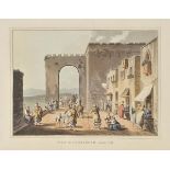
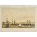
![[Gray, James]. Life in Bombay, and the Neighbouring Out-Stations, 1st ed., Richard Bentley, 1852,](https://portal-images.azureedge.net/auctions-2015/srdom10015/images/691aea25-4cf6-4213-bba2-806763be647a.jpg?w=155&h=155)
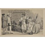
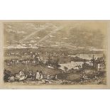
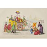
[Gray, James]. Life in Bombay, and the Neighbouring Out-Stations, 1st ed., Richard Bentley, 1852,
[Gray, James]. Life in Bombay, and the Neighbouring Out-Stations, 1st ed., Richard Bentley, 1852, half title, 12 tinted lithographed plates, illus...
Hall (Sidney). A New General Atlas with the Divisions and Boundaries carefully coloured; Constructed
Hall (Sidney). A New General Atlas with the Divisions and Boundaries carefully coloured; Constructed Entirely from New Drawings...., pub. Longman,...
Heber (Reginald). Narrative of a Journey through the Upper Provinces of India, from Calcutta to
Heber (Reginald). Narrative of a Journey through the Upper Provinces of India, from Calcutta to Bombay, 1824-1825. (With Notes upon Ceylon, ) An A...
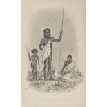
Henderson (John). Excursions and Adventures in New South Wales; with Pictures of Squatting and of
Henderson (John). Excursions and Adventures in New South Wales; with Pictures of Squatting and of Life in the Bush... Together with a Prefatory Ch...
Heyl (James B.). Bermuda through the Camera of James B. Heyl 1868-1897, 1st edition, Hamilton,
Heyl (James B.). Bermuda through the Camera of James B. Heyl 1868-1897, 1st edition, Hamilton, Bermuda, 1951, b & w illustrations from photos thro...
Hillary (Edmund). High Adventure, 1st ed., 1955, colour frontispiece, half-tone illustrations,
Hillary (Edmund). High Adventure, 1st ed., 1955, colour frontispiece, half-tone illustrations, scattered light spotting, original blue cloth (spin...
Hillary (Edmund). High Adventure, 1st ed., 1955, colour frontispiece, b & w illustrations, original blue cloth, one or two light mottled stains, d...
Hunt (John). The Ascent of Everest, 1st ed., 1953, colour and b & w illustrations, light offsetting to endpapers, original blue cloth, price-clipp...
Hunt (John). The Ascent of Everest, 1st ed., pub. Hodder & Stoughton, 1953, signed by the author
Hunt (John). The Ascent of Everest, 1st ed., pub. Hodder & Stoughton, 1953, signed by the author in blue ink to title, colour frontis., several co...
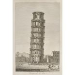
Italy - Rome & Pisa. A volume of views of Rome, early 19th c., comprising ninety-nine engraved
Italy - Rome & Pisa. A volume of views of Rome, early 19th c., comprising ninety-nine engraved plates of Rome after Achille Parboni and Tommaso Cu...
Johnston (Alexander Keith). The Royal Atlas of Modern Geography, A New Edition, pub. W. & A.K.
Johnston (Alexander Keith). The Royal Atlas of Modern Geography, A New Edition, pub. W. & A.K.Johnston, 1888, addn. half title, fifty-four (comple...
Kircher (Athanasius). La Chine Illustree de Plusieurs Monuments tant Sacres que Profanes, et dequantite de Recherches de la Nature & de l’Art, 1st...
Knapp (Samuel L.). The History and Topography of the United States of North America, 2 vols., new
Knapp (Samuel L.). The History and Topography of the United States of North America, 2 vols., new ed., Boston, 1834, frontispiece and additional e...
La Croix (A. Pherotée de). Nouvele metode pour apprendre la geographie universele..., vols. 1-3 (
La Croix (A. Pherotée de). Nouvele metode pour apprendre la geographie universele..., vols. 1-3 (of 5), 3rd ed., Lyon: Leonard Plaignard, 1717, ad...
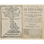
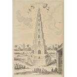
Laffi (Domenico). Viaggio in Levante al Santo Sepolcro ... et altri luoghi di Terra Santa, 1st
Laffi (Domenico). Viaggio in Levante al Santo Sepolcro ... et altri luoghi di Terra Santa, 1st edition, Bologna, Eredi d’Antonio Pisarri, 1683, ha...
Lafond (Gabriel). Voyages autour du mond et naufrages célèbres, 8 volumes bound in 4, Paris, 1843-44, engraved portrait, 77 engraved plates and...
Little (Archibald John). Mount Omi and Beyond. A Record of Travel on the Thibetan Border, 1st ed.,
Little (Archibald John). Mount Omi and Beyond. A Record of Travel on the Thibetan Border, 1st ed., 1901, portrait frontispiece, folding map, half-...
Lizars (W.H. pubs.). Lizars’ Edinburgh Geographical General Atlas: Containing Maps of Every Empire, State and Kingdom....., pub. Edinburgh, c.1840...
Madden (Richard Robert). Travels in Turkey, Egypt, Nubia, and Palestine, in 1824, 1825, 1826, and
Madden (Richard Robert). Travels in Turkey, Egypt, Nubia, and Palestine, in 1824, 1825, 1826, and 1827, 2 vols., 1st ed., 1829, half title to vol....
Marchand (Etienne). Voyage Autour du Monde, pendant les Annees 1790, 1791 et 1792... Precede d’une
Marchand (Etienne). Voyage Autour du Monde, pendant les Annees 1790, 1791 et 1792... Precede d’une Introduction Historique; auquel on a Joint des ...

Marmol Carvajal (Luis del). L’Afrique de Marmol, de la Traduction de Bicolas Perrot sieur d’Ablancourt..., avec l’Histoire des Cherifs, traduite d...
Mathews (Charles Edward). The Annals of Mont Blanc. A Monograph, 1st ed., 1898, folding colour
Mathews (Charles Edward). The Annals of Mont Blanc. A Monograph, 1st ed., 1898, folding colour map, b & w plates (one loose), occasional minor spo...