
Filtered by:
- Category
- List
- Grid
A subscription to the Price Guide is required to view results for auctions ten days or older. Click here for more information

SUFFOLK BOOKS: White's Gazeteer 1855 (no map) and 98 others of Suffolk interest (99 TOTAL).
PATERSON'S ROADS 16TH EDITION, 1822 large general map of roads of England and Wales and 8 other
PATERSON'S ROADS 16TH EDITION, 1822 large general map of roads of England and Wales and 8 other folding maps with another copy, 18th Edition, 10 f...
STOCKDALE 1800 A GEOGRAPHICAL HISTORICAL AND POLITICAL DESCRIPTION OF THE EMPIRE OF GERMANY, HOLLAND
STOCKDALE 1800 A GEOGRAPHICAL HISTORICAL AND POLITICAL DESCRIPTION OF THE EMPIRE OF GERMANY, HOLLAND (ETC) in two leather cases, includes an index...
TAYLOR AND SKINNERS SURVEY AND MAPS of North Britain or Scotland, 1776. (Maps similar to Ogilvie's
TAYLOR AND SKINNERS SURVEY AND MAPS of North Britain or Scotland, 1776. (Maps similar to Ogilvie's style).
CARTE GENERALE DE LA FRANCE BY M. CAPITAINE, ingenieur geographique du roi 1790. Large folding map
CARTE GENERALE DE LA FRANCE BY M. CAPITAINE, ingenieur geographique du roi 1790. Large folding map hand coloured.
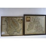
CARY'S REDUCTION OF HIS LARGE MAP OF ENGLAND, WALES AND PART OF SCOTLAND, with a Royal Atlas (by Rev
CARY'S REDUCTION OF HIS LARGE MAP OF ENGLAND, WALES AND PART OF SCOTLAND, with a Royal Atlas (by Rev John Evans) 1810 and a new map of Ireland by ...
OGILBY'S ROAD MAPS OF ENGLAND AND WALES, 1675 reprinted 1971. Fine copy and 14 others (15 total).
OGILBY'S ROAD MAPS OF ENGLAND AND WALES, 1675 reprinted 1971. Fine copy and 14 others (15 total).

EMAN BOWEN, AN 18TH CENTURY COLOURED MAP, an accurate map of the county of Norfolk, 21 ins x 28 ins,
EMAN BOWEN, AN 18TH CENTURY COLOURED MAP, an accurate map of the county of Norfolk, 21 ins x 28 ins, framed.
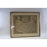
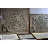
JOHN SPEED, AN 18TH CENTURY COLOURED MAP OF SUFFOLK, with inset of Ipswich town and heraldic Suffolk
JOHN SPEED, AN 18TH CENTURY COLOURED MAP OF SUFFOLK, with inset of Ipswich town and heraldic Suffolk family arms to border, 15 ins x 20 ins, frame...
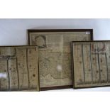
EMAN BOWEN, AN 18TH CENTURY COLOURED MAP OF SUFFOLK, 16 ins x 19 1/2 ins and two coloured STRIP MAPS
EMAN BOWEN, AN 18TH CENTURY COLOURED MAP OF SUFFOLK, 16 ins x 19 1/2 ins and two coloured STRIP MAPS by John Ogilby of The Road from London to Kin...
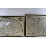
AN 18TH CENTURY COLOURED MAP OF NORFOLK by Robert Morden, 24 ins x 15 ins and a monochrome MAP OF
AN 18TH CENTURY COLOURED MAP OF NORFOLK by Robert Morden, 24 ins x 15 ins and a monochrome MAP OF SUFFOLK with a banner of heraldic shields to the...
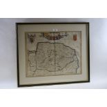
AN 18TH CENTURY HAND COLOURED MAP OF NORFOLK with a banner of heraldic shields, 14 ins x 19 ins,
AN 18TH CENTURY HAND COLOURED MAP OF NORFOLK with a banner of heraldic shields, 14 ins x 19 ins, framed.

H. OVERTON, AN 18TH CENTURY COLOURED MAP OF NORFOLK with inset town plan of Norwich, 15 1/2 ins x 20
H. OVERTON, AN 18TH CENTURY COLOURED MAP OF NORFOLK with inset town plan of Norwich, 15 1/2 ins x 20 ins and a smaller DITTO OF SUFFOLK by Robert ...
ROBERT MORDEN, AN 18TH CENTURY COLOURED MAP OF LINCOLNSHIRE, 14 ins x 16 1/2 ins and a coloured
ROBERT MORDEN, AN 18TH CENTURY COLOURED MAP OF LINCOLNSHIRE, 14 ins x 16 1/2 ins and a coloured MAP OF BRITANNIA, Romana, 14 ins x 16 1/2 ins, fra...
RICHARD BLOME, AN 18TH CENTURY COLOURED MAP OF SCOTLAND, damage to border, 15 ins x 16 ins, a
RICHARD BLOME, AN 18TH CENTURY COLOURED MAP OF SCOTLAND, damage to border, 15 ins x 16 ins, a coloured MAP OF GRAECIA, by Carolus Allard, 17 1/2 i...