Filtered by:
- Category
5 items
- List
- Grid
A subscription to the Price Guide is required to view results for auctions ten days or older. Click here for more information
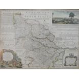

Lot 20
After Emanuel Bowen (British 1694-1767), 'An Accurate Map of the West Riding of Yorkshire Divided
After Emanuel Bowen (British 1694-1767), 'An Accurate Map of the West Riding of Yorkshire Divided into its Wapontakes' with a view of the City of ...

Lot 154
A framed and glazed 19th century engraved topographical map of Start Bay, Devon. H.69 W.97cm.
A framed and glazed 19th century engraved topographical map of Start Bay, Devon. H.69 W.97cm.

Lot 202
After Emanuel Bowen (British 1694-1767), 'An Accurate Map of the East Riding of York Shire divided
After Emanuel Bowen (British 1694-1767), 'An Accurate Map of the East Riding of York Shire divided into its Wapontakes &c...', hand tinted engravi...

A 19th century hand coloured engraved strip map of York to Lancashire. H.26 W.28cm

Lot 335
Two framed and glazed vintage maps, one of The Central Bus Routes of London and a map of the
Two framed and glazed vintage maps, one of The Central Bus Routes of London and a map of the wildlife of the Forest of Wyre by Norman Hickin. H.4...